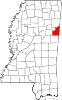
Lowndes County is a county on the eastern border of the U.S. state of Mississippi. As of the 2020 United States Census, the population was 58,879. Its county seat is Columbus. The county is named for U.S. Congressman and slave owner William Jones Lowndes.

Forreston is a village in Ogle County, Illinois, United States. The population was 1,446 at the 2010 census, down from 1,469 in 2000.

Booneville is a city in the U.S. state of Mississippi and is the county seat of Prentiss County. It is located in the hilly North Mississippi region, and ecologically is part of the Southeastern Plains region.

Jacques Marquette, S.J., sometimes known as Père Marquette or James Marquette, was a French Jesuit missionary who founded Michigan's first European settlement, Sault Sainte Marie, and later founded Saint Ignace. In 1673, Marquette, with Louis Jolliet, an explorer born near Quebec City, was the first European to explore and map the northern portion of the Mississippi River Valley.
Idlewild, also spelled Idlewyld, Idyllwild, Idyllwyld, Idylwild, or Idylwyld might refer to:
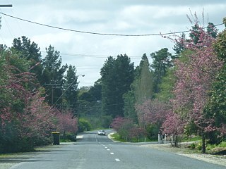
Forreston is a locality near Adelaide, South Australia. It is located in the Adelaide Hills Council local government area 3 km northeast of Gumeracha.
The following is a set–index article, providing a list of lists, for the cities, towns and villages within the jurisdictional United States. It is divided, alphabetically, according to the state, territory, or district name in which they are located.

Forreston Township is located in Ogle County, Illinois. As of the 2010 census, its population was 2,080 and it contained 885 housing units. Forreston Township was formed from a portion of Brookville Township on March 4, 1857. The village of Forreston and the unincorporated community of Baileyville are located within it.

The Columbus-West Point, MS Combined Statistical Area was formerly defined as consisting of Clay and Lowndes counties in northeastern Mississippi, which were separately treated as the West Point Micropolitan Statistical Area and Columbus Micropolitan Statistical Area, respectively. As of the 2000 census, the CSA had a population of 83,565. A July 1, 2009 estimate placed the population at 80,380.

Haldane is an unincorporated community in Ogle County, Illinois, United States, located south of Forreston and west of Mount Morris.
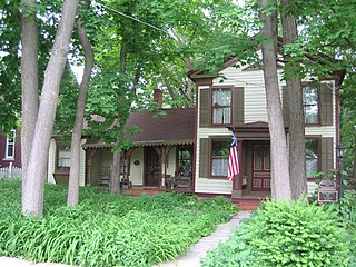
The Lampert-Wildflower House is a home in the U.S. city of Belvidere, Boone County, Illinois. The main, upright, portion of the house was constructed in 1838 and the wing section was added to the home during the 1860s. It passed through the hands of several owners until it was purchased by Phillip C. Lampert who is responsible for the wildflower covered lawn. The property contains five types of rare plants and is semi-wooded, shaded by 32 trees. The home is a distinct example of Upright and Wing construction, though it retains some elements of the Greek Revival style it was originally designed in. The wing section of the house features a front porch decorated with Gothic Revival and Queen Anne style elements. The house was listed on the U.S. National Register of Historic Places for its architectural significance in 2005.

Forreston is an unincorporated community in Ellis County, Texas, United States. It lies on U.S. Route 77 eight miles south of the county seat of Waxahachie. Its population was estimated to be 238 in 2008, but it is not listed in the 2010 census.

Kent is an unincorporated community in Stephenson County, Illinois. Kent is home to Forreston State Bank, Kent Feed Mill, St. Paul's Lutheran Church (ELCA), Kent United Methodist Church, Kent Fire Department and the Kent U.S. Post Office.

Wisconsin, a state in the Midwestern United States, has a vast and diverse geography famous for its landforms created by glaciers during the Wisconsin glaciation 17,000 years ago. The state can be generally divided into five geographic regions—Lake Superior Lowland, Northern Highland, Central Plain, Eastern Ridges & Lowlands, and Western Upland. The southwestern part of the state, which was not covered by glaciers during the most recent ice age, is known as the Driftless Area. The Wisconsin glaciation formed the Wisconsin Dells, Devil's Lake, and the Baraboo Range. A number of areas are protected in the state, including Devil's Lake State Park, the Apostle Islands National Lakeshore, and the Chequamegon–Nicolet National Forest.
Michigan City, formerly known as Davis Mills, is an unincorporated community in Benton County, Mississippi, United States. Although unincorporated, Michigan City has a post office, with the ZIP code of 38647.
Early Grove is an unincorporated community located in Marshall County, Mississippi, United States, near the Mississippi/Tennessee border. Early Grove is approximately 11 miles (18 km) west of Michigan City, approximately 10 miles (16 km) east of Mount Pleasant and approximately 20 miles (32 km) southeast of Collierville, north of U.S. Route 72.