Monroe County is a county on the northeast border of the U.S. state of Mississippi next to Alabama. As of the 2020 census, the population was 34,180. Its county seat is Aberdeen.
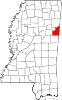
Lowndes County is a county on the eastern border of the U.S. state of Mississippi. As of the 2020 United States Census, the population was 58,879. Its county seat is Columbus. The county is named for U.S. Congressman and slave owner William Jones Lowndes.

Hayneville is a town in Lowndes County, Alabama, United States and its county seat. At the 2010 census the population was 932, down from its record high of 1,177 in 2000. It is also part of the Montgomery Metropolitan Statistical Area. It initially incorporated in 1831, but lapsed, finally reincorporating in 1967. Before 1970, the town appeared only twice on the U.S. Census: in 1850 and 1890. The 1850 estimate of 800 residents ranked it as the largest town in the county at the time.

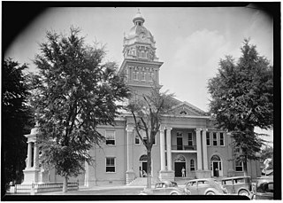
Columbus is a city in and the county seat of Lowndes County, on the eastern border of Mississippi, United States, located primarily east, but also north and northeast of the Tombigbee River, which is also part of the Tennessee-Tombigbee Waterway. It is approximately 146 miles (235 km) northeast of Jackson, 92 miles (148 km) north of Meridian, 63 miles (101 km) south of Tupelo, 60 miles (97 km) northwest of Tuscaloosa, Alabama, and 120 miles (193 km) west of Birmingham, Alabama.

Minter City is an unincorporated community in Leflore County and Tallahatchie County, Mississippi. It is part of the Greenwood, Mississippi micropolitan area, and is within the Mississippi Delta.

Mississippi Highway 69 is a state highway in eastern Mississippi. The route starts at the Alabama state line, and travels northwestward to Columbus. MS 69 then goes through downtown Columbus, and ends at U.S. Route 45 and US 82 in the west side of the town. Before the road was designated as MS 69 in 1941, it was a gravel road from Columbus to the state line. The road was paved in asphalt in 1953. In 1992, US 82 was realigned, and MS 69 was extended through Columbus to its current northern terminus.
McLaurin is a small unincorporated community in Forrest County, Mississippi, United States.
Billups is an unincorporated community in Lowndes County, Mississippi.
Plymouth was an early settlement in Mississippi in present-day Lowndes County. Plymouth was located on the west bank of the Tombigbee River at the mouth of Tibbee Creek.

Mayhew is an unincorporated community in Lowndes County, Mississippi.
Steens, also known as Jamisons Mill, is an unincorporated community in Lowndes County, Mississippi. Steens is located northeast of Columbus. The ZIP Code for Steens is 39766.
Bent Oak is an unincorporated community in Lowndes County, Mississippi. According to the United States Geological Survey, variant names are Cobbs Switch, Bentoak, and Cobbs.
Forreston is an unincorporated community in Lowndes County, Mississippi.
Kolola Springs is an unincorporated community in Lowndes County, Mississippi.
Penns, also known as Penn or Penns Station, is an unincorporated community in Lowndes County, Mississippi. Penns is located south of Artesia on U.S. Route 45.
Trinity is an unincorporated community in Lowndes County, Mississippi. Trinity is located south of Columbus. According to the United States Geological Survey, a variant name is Bryans Store.

Stege, founded in 1876, was an unincorporated community in western Contra Costa County, California, United States. The town has now been annexed and absorbed by the cities of Richmond and El Cerrito, California. It was located on the Southern Pacific Railroad 1.5 miles (2.4 km) south-southeast of downtown Richmond, at an elevation of 23 feet. The site is now located in the area known as the Richmond Annex, at coordinates: 37°55′00″N122°19′38″W.

Binnsville is a ghost town in Kemper County, Mississippi, United States.
Alamucha is an unincorporated community in Lauderdale County, Mississippi, United States.

Wingate is an unincorporated community located in Perry County, Mississippi.