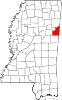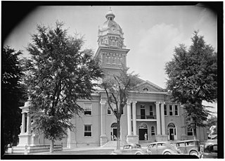
Lowndes County is a county on the eastern border of the U.S. state of Mississippi. As of the 2020 United States Census, the population was 58,879. Its county seat is Columbus. The county is named for U.S. Congressman William Jones Lowndes.

Murray County is a county in the Northwest region of the U.S. state of Georgia. As of the 2020 census, the population was 39,973. The county seat is Chatsworth. Murray County is part of the Dalton, GA Metropolitan Statistical Area, which is also included in the Chattanooga-Cleveland-Dalton, TN-GA-AL Combined Statistical Area.
Hamilton is a census-designated place and unincorporated community in Monroe County, Mississippi, United States. As of the 2020 census, it had a population of 404.
Foster is a small unincorporated community in Mound Township, Warren County, in the U.S. state of Indiana.
New Hamilton is a census-designated place and unincorporated community in Monroe County, Mississippi, United States, next to the older community of Hamilton. As of the 2020 census, it had a population of 533. The Hamilton post office, serving both communities, is located in New Hamilton.
Greenwood Springs is an unincorporated community in Monroe County, Mississippi. Greenwood Springs is located east of Amory on U.S. Route 278.
Wren,, is an unincorporated community in Monroe County, Mississippi.
Billups is an unincorporated community in Lowndes County, Mississippi.

Mayhew is an unincorporated community in Lowndes County, Mississippi.
Steens, also known as Jamisons Mill, is an unincorporated community in Lowndes County, Mississippi. Steens is located northeast of Columbus. The ZIP Code for Steens is 39766.
Bent Oak is an unincorporated community in Lowndes County, Mississippi. According to the United States Geological Survey, variant names are Cobbs Switch, Bentoak, and Cobbs.
McCrary is an unincorporated community in Lowndes County, Mississippi. McCrary is located southeast of Columbus and northeast of New Hope on the Mississippi/Alabama state line.
Penns, also known as Penn or Penns Station, is an unincorporated community in Lowndes County, Mississippi. Penns is located south of Artesia on U.S. Route 45.
Plum Grove is an unincorporated community in Lowndes County, Mississippi. Plum Grove is located south of Columbus.
Trinity is an unincorporated community in Lowndes County, Mississippi. Trinity is located south of Columbus. According to the United States Geological Survey, a variant name is Bryans Store.
Woodlawn is an unincorporated community in Lowndes County, Mississippi. Woodlawn is located northeast of Columbus on Mississippi Highway 12. According to the United States Geological Survey, a variant name is Woods Lawn.

The Starkville–Columbus, MS Combined Statistical Area was formerly known as Columbus–West Point was defined as consisting of Clay and Lowndes counties in northeastern Mississippi, which were separately treated as the West Point Micropolitan Statistical Area and Columbus Micropolitan Statistical Area, respectively. As of the 2000 census, the CSA had a population of 83,565.

Moselle is a census-designated place and unincorporated community in southern Jones County, Mississippi. The community is part of the Laurel micropolitan area.

Eastabuchie is a census-designated place and unincorporated community in southwestern Jones County, Mississippi. It is located along U.S. Route 11, just north of the Forrest County line. the community has a post office with the ZIP code 39436. Eastabuchie is part of the Laurel Micropolitan Statistical Area.
Early Grove is an unincorporated community located in Marshall County, Mississippi, United States, near the Mississippi/Tennessee border. Early Grove is approximately 11 miles (18 km) west of Michigan City, approximately 10 miles (16 km) east of Mount Pleasant and approximately 20 miles (32 km) southeast of Collierville, north of U.S. Route 72.