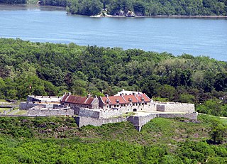
Fort Ticonderoga, formerly Fort Carillon, is a large 18th-century star fort built by the French at a narrows near the south end of Lake Champlain, in northern New York, in the United States. It was constructed by Canadian-born French military engineer Michel Chartier de Lotbinière, Marquis de Lotbinière between October 1755 and 1757, during the action in the "North American theater" of the Seven Years' War, often referred to in the US as the French and Indian War. The fort was of strategic importance during the 18th-century colonial conflicts between Great Britain and France, and again played an important role during the Revolutionary War.

Hamilton is a town in Martin County, North Carolina, United States. The population was 408 at the 2010 census.

Plymouth is the largest town in Washington County, North Carolina, United States. The population was 3,878 at the 2010 census. It is the county seat of Washington County. Plymouth is located on the Roanoke River about seven miles (11 km) upriver from its mouth into the Albemarle Sound in North Carolina's Inner Banks region.

Fort Matanzas National Monument was designated a United States National Monument on October 15, 1924. The monument consists of a 1740 Spanish fort called Fort Matanzas, and about 100 acres (0.4 km²) of salt marsh and barrier islands along the Matanzas River on the northern Atlantic coast of Florida. It is operated by the National Park Service in conjunction with the Castillo de San Marcos National Monument in the city of St. Augustine.

Fort Fisher was a Confederate fort during the American Civil War. It protected the vital trading routes of the port at Wilmington, North Carolina, from 1861 until its capture by the Union in 1865. The fort was located on one of Cape Fear River's two outlets to the Atlantic Ocean on what was then known as Federal Point or Confederate Point and today is known as Pleasure Island. The strength of Fort Fisher led to its being called the Southern Gibraltar and the "Malakoff Tower of the South". The battle of Fort Fisher was the most decisive battle of the Civil War fought in North Carolina.

The Cherokee Path was the primary route of English and Scots traders from Charleston to Columbia, South Carolina in Colonial America. It was the way they reached Cherokee towns and territories along the upper Keowee River and its tributaries. In its lower section it was known as the Savannah River. They referred to these towns along the Keowee and Tugaloo rivers as the Lower Towns, in contrast to the Middle Towns in Western North Carolina and the Overhill Towns in present-day southeastern Tennessee west of the Appalachian Mountains.

Fort Whoop-Up was the nickname given to a whisky trading post, originally Fort Hamilton, near what is now Lethbridge, Alberta. During the late 19th century, the post served as a centre for trading activities, including the illegal whisky trade. The sale of whisky was outlawed but, due to the lack of law enforcement in the region prior to 1874, many whisky traders had settled in the area and taken to charging unusually high prices for their goods.

The National Register of Historic Places in the United States is a register including buildings, sites, structures, districts, and objects. The Register automatically includes all National Historic Landmarks as well as all historic areas administered by the U.S. National Park Service. Since its introduction in 1966, more than 90,000 separate listings have been added to the register.

Fort Raleigh National Historic Site preserves the location of Roanoke Colony, the first English settlement in the present-day United States. The site was preserved for its national significance in relation to the founding of the first English settlement in North America in 1587. The colony, which was promoted and backed by entrepreneurs led by Englishman Sir Walter Raleigh, failed sometime between 1587 and 1590 when supply ships failed to arrive on time. When next visited, the settlement was abandoned with no survivors found. The fate of the "Lost Colony" was a celebrated mystery, although most modern academic sources agree that the settlers likely assimilated into local indigenous tribes.

Paynes Creek Historic State Park is a Florida State Park located on Lake Branch Road one-half mile southeast of Bowling Green, Florida. On November 21, 1978, it was added to the United States National Register of Historic Places, under the title of Payne's Creek Massacre-Fort Chokonikla Site.
Ninety Six National Historic Site, also known as Old Ninety Six and Star Fort, is a United States National Historic Site located about 60 miles south of Greenville, South Carolina. The historic site was listed on the National Register in 1969, declared to be a National Historic Landmark in 1973, and established as a National Historic Site in 1976 to preserve the original site of Ninety Six, South Carolina, a small town established in the early 18th century. It encompasses 1,022 acres of property.

Fort Griffin, now a Texas state historic site as Fort Griffin State Historic Site, was a US Cavalry fort established 31 July 1867 by four companies of the Sixth Cavalry, U.S. Army under the command of Lt. Col. S.D. Sturgis, in the northern part of West Texas, specifically northwestern Shackelford County, to give settlers protection from early Comanche and Kiowa raids. Originally called Camp Wilson after Henry Hamilton Wilson, a recently deceased lieutenant, it was later named for Charles Griffin, a former Civil War Union general who had commanded, as de facto military governor, the Department of Texas during the early years of Reconstruction.

Fort Neoheroka, or Nooherooka, is the name of a stronghold constructed in what is now Greene County, North Carolina by the Tuscarora tribe during the Tuscarora War of 1711–1715. In March 1713, the fort was besieged and ultimately attacked by a colonial force consisting of an army from the neighboring Province of South Carolina, under the command of Colonel James Moore and made up mainly of Indians including Yamasee, Apalachee, Catawba, and Cherokee. The 1713 siege lasted for more than three weeks, from around March 1 to March 22, 1713. Hundreds of men, women and children were burned to death in a fire that destroyed the fort. Approximately 170 more were killed outside the fort while approximately 400 were taken to South Carolina where they were sold into slavery. The defeat of the Tuscaroras, once the most powerful Indian tribe in the Province of North Carolina, opened up North Carolina's interior to further settlement. The supremacy of the Tuscaroras in the colony was broken forever, and most moved north to live among the Iroquois. On July 17, 2009, the Fort Neoheroka Site was added to the National Register of Historic Places.

Long Island, also known as Long Island of the Holston, is an island in the Holston River at Kingsport in East Tennessee. Important in regional history since pre-colonial times, the island is listed on the National Register of Historic Places and is designated as a U.S. National Historic Landmark District.

Fort Anderson is a mid-19th-century earthen fort in the lower Cape Fear Region of North Carolina, located over the ruins of the colonial town of Brunswick in Brunswick County. It was used as a Confederate Fort during the American Civil War. The fort was pivotal in protecting the Cape Fear River inlets and Wilmington upstream. Earthen batteries comprise the fort and were used as platforms and shields for the Confederate cannons. Beneath some of the earthworks were "bombproofs," shelters used by troops during enemy bombardment. The Confederacy decided to build forts around the Cape Fear River to protect the port of Wilmington from the Union blockade. During the Civil War, blockade runners brought supplies such as iron, guns, and ammunition to the Confederacy. The purpose of the fort was to hinder movement of Union ships, and to serve as a dropping off point for blockade runners fortunate enough to make it up the mouth of the Cape Fear River. Fort Anderson was built on the ruins of Brunswick Town and was originally named Fort St. Philip, after the ruins of the Revolutionary period church nearby. The name was changed to honor Col. George B. Anderson.
The Portsmouth Earthworks are a large prehistoric mound complex constructed by the Ohio Hopewell culture mound builder indigenous peoples of eastern North America. The site was one of the largest earthwork ceremonial centers constructed by the Hopewell and is located at the confluence of the Scioto and Ohio Rivers, in present-day Ohio.

Fort Johnson is a state-owned historic site of military and political significance located on the northeast point of James Island in Charleston County, South Carolina.
Located in North Carolina on the Atlantic Coast, the Fort Caswell Historic District encompasses 2 sites, 43 buildings, and 23 structures; it was added to the National Register of Historic Places in 2013. The fort itself was occupied by various branches of the U.S. armed forces for most of the period between 1836 and 1945 and is now a part of the North Carolina Baptist Assembly, a Christian retreat, owned and operated by the Baptist State Convention of NC. It is accessible by the public to a limited extent per the conditions set forth by the Assembly’s Director.
The Rhodes Site, designated 31BR90, is a prehistoric archaeological site near Hamilton, North Carolina. It is a deeply buried midden located on the eastern bank of the Roanoke River, and has been dated to the Middle and Late Woodland Periods. The site was listed on the National Register of Historic Places in 1986.


