
Laramie is a city in and the county seat of Albany County, Wyoming, United States, known for its high elevation at 7,200 feet (2,200 m), railroad history, and as the higher-education center for the state of Wyoming. The population was estimated 31,407 in 2020, making it the 4th most populous city in Wyoming. Located on the Laramie River in southeastern Wyoming, the city is west of Cheyenne and 25 miles (40 km) north of the Colorado state line, at the junction of Interstate 80 and U.S. Route 287.

The Wyoming State Capitol is located in the city of Cheyenne. Cheyenne is the seat of government for the U.S. state of Wyoming. Built between 1886 and 1890, the capitol is located in Cheyenne and contains the chambers of the Wyoming State Legislature as well as the office of the Governor of Wyoming. It was designated a U.S. National Historic Landmark in 1987. The Capitol underwent an extensive three-year renovation and reopened to the public on July 10, 2019.

Fort Laramie was a significant 19th-century trading post, diplomatic site, and military installation located at the confluence of the Laramie and the North Platte Rivers. They joined in the upper Platte River Valley in the eastern part of the present-day U.S. state of Wyoming. The fort was founded as a private trading-post in the 1830s to service the overland fur trade; in 1849, it was purchased by the United States Army. The site was located east of the long climb leading to the best and lowest crossing-point over the Rocky Mountains at South Pass and became a popular stopping-point for migrants on the Oregon Trail. Along with Bent's Fort on the Arkansas River, the trading post and its supporting industries and businesses were the most significant economic hub of commerce in the region.

Fort D. A. Russell, also known as Fort Francis E. Warren, Francis E. Warren Air Force Base and Fort David A. Russell, was a post and base of operations for the United States Army, and later the Air Force, located in Cheyenne, Wyoming. The fort had been established in 1867 to protect workers for the Union Pacific Railroad. It was named in honor of David Allen Russell, a Civil War general killed at the Battle of Opequon. In 1930, the fort's name was changed to Fort Francis E. Warren. In 1949, it became Francis E. Warren Air Force Base.

Fort Fetterman was constructed in 1867 by the United States Army on the Great Plains frontier in Dakota Territory, approximately 11 miles northwest of present-day Douglas, Wyoming. Located high on the bluffs south of the North Platte River, it served as a major base for the start of several United States military expeditions against warring Native American tribes. The fort is listed on the National Register of Historic Places.
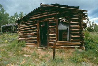
Hamilton City, or Miner's Delight as it was commonly known, was a town in Fremont County, Wyoming, United States, on the southeastern tip of the Wind River Range, that prospered during the mining boom in the American West in the second half of the 19th century. It was a "sister city" of Atlantic City and South Pass City. Today a few buildings still stand as a reminder of an era in Wyoming's past history.
The Cheyenne Depot Museum is a railroad museum in Cheyenne, Wyoming, United States. It is located inside the 1880s Union Pacific Railroad depot. A National Historic Landmark, the station was the railroad's largest west of Council Bluffs, Iowa, and a major western example of Richardsonian Romanesque architecture.

The TA Ranch was the site of the principal events of the Johnson County Range War in 1892. The TA was established in 1882 as one of the first ranches in Johnson County, Wyoming. The TA is the only intact site associated with the range war, with trenches used by both sides still visible and scars on the nearby buildings. The ranch also documents the expansion and development of cattle ranching in Wyoming.

The Rawhide Buttes Stage Station, the Running Water Stage Station and the Cheyenne–Black Hills Stage Route comprise a historic district that commemorates the stage coach route between Cheyenne, Wyoming, and Deadwood, South Dakota. The route operated beginning in 1876, during the height of the Black Hills Gold Rush, and was replaced in 1887 by a railroad.

The Oxford Horse Barn, built in 1887, is located near Laramie, Wyoming in Albany County, Wyoming. It is one of the oldest and largest existing barns in Albany County. The barn in an excellent example of vernacular architecture as influenced by the English cattle and horse ranchers which immigrated to the American West. It is listed on the National Register of Historic Places.

The N.K. Boswell Ranch is one of the oldest ranches on the edge of the Laramie Plains along the Big Laramie River in Albany County, Wyoming, USA. The ranch was established in the early 1870s, possibly by a man named C.T. Waldron. The ranch is significant for its association with Nathaniel K. Boswell, who was Albany County Sheriff at a time when the county extended from Colorado to Montana.

Fort Steele, also known as Fort Fred Steele, was established to protect the newly built Union Pacific Railroad from attacks by Native Americans during construction of the transcontinental railroad in the United States. The fort was built in 1868 where the railroad crossed the North Platte River in Carbon County, Wyoming. Work on the fort was carried out by military and civilian labor. Fort Steele was one of three forts built on the line. Fort Sanders near Laramie and Fort D.A. Russell at Cheyenne were the other railroad forts. Fort Steele was named for the recently deceased General Frederick Steele.
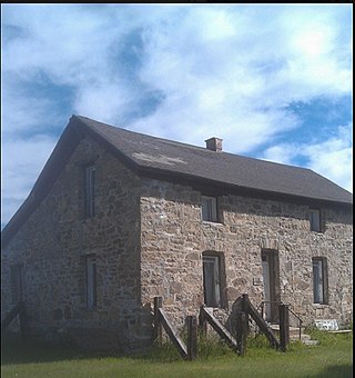
The Bath Ranch, also known as the Bath Brothers Ranch and the Stone Ranch, was established near Laramie, Wyoming by Henry Bath about 1869-70. It was one of the first ranches in Albany County. The initial homestead was replaced by the present stone house and barn in 1875, using stone quarried locally by Henry and his sons. Since the area was populated by hostile Native Americans, the buildings were designed as fortified refuges. The Bath family became prominent in Wyoming society in subsequent years.
The Flying Horseshoe Ranch was established in the Centennial Valley of southeastern Wyoming by Danish immigrant Mads Wolbol in the late 1870s. The complex of mostly log structures, about 15 of which are considered contributing structures.
The Jelm-Frank Smith Ranch Historic District, also known as Old Jelm and Cummins City, comprises an area of bottomland on the Laramie River near Woods Landing, Wyoming where the mining boomtown of Cummins City, Wyoming was established in 1880. Gold had been discovered in the nearby mountains and the town was established by W.S. "Buck" Bramel and John Cummins. In 1881 Cummins City was described as having about 100 houses and a hotel. By this time the camp was already declining, and by 1886 mining in the district was largely inactive. However, in the 1890s copper was discovered in the Sierra Madre and Medicine Bow ranges. Cummins City was revived as Jelm in 1900. This boom also declined and in 1930 Jelm's population was 50.
The Ryan Ranch is a 2,000-acre (810 ha) ranch on the east bank of the North Platte River in Carbon County, Wyoming, about 8 miles (13 km) south of Saratoga. One of the oldest ranches in the Platte Valley of central Wyoming, it was founded by Barton T. Ryan in 1874 and expanded by his son Cecil A. Ryan. The ranch headquarters comprises 17 structures arranged around a barnyard. The oldest structure is the 1875 homestead. Other buildings include sheds, shops, guest cabins, barns, trailers and a privy.
The CM Ranch and Simpson Lake Cabins are separate components of a single historic district associated with Charles Cornell Moore, a Fremont County, Wyoming dude ranch operator. The CM ranch, named after Moore, operated as a dude ranch from 1920 to 1942 and resumed operating in 1945. The Simpson Lake Cabins were purchased by Moore in 1931 and were operated as a hunting camp, continuing until 1997 when the CM ranch was sold to new owners and the Simpson Lake property was taken over by the U.S. Forest Service.. The sites are separated by 13 miles (21 km).
The Crow Creek-Cole Ranch Headquarters Historic District, in Laramie County, Wyoming near Cheyenne, dates from 1879. It was listed on the National Register of Historic Places in 2009 as Crow Creek-Cole Ranch Headquarters Historic District
Remount Ranch, in Laramie County, Wyoming near Cheyenne, Wyoming, is a pioneer cattle and horse ranch which dates from 1875. It was listed on the National Register of Historic Places in 1990. The listing included four contributing buildings and four contributing structures.

John Wesley Prowers was an American trader, cattle rancher, legislator, and businessman in the territory and state of Colorado. Married to Amache Prowers, a Cheyenne woman, his father-in-law was a Cheyenne chief who negotiated for peace and was killed during the Sand Creek massacre.

