
Sullivan's Island is a town and island in Charleston County, South Carolina, United States, at the entrance to Charleston Harbor, with a population of 1,791 at the 2010 census. The town is part of the Charleston metropolitan area, and is considered a very affluent suburb of Charleston.
The Stono Rebellion was a slave revolt that began on 9 September 1739, in the colony of South Carolina. It was the largest slave rebellion in the Southern Colonies, with 25 colonists and 35 to 50 Africans killed. The uprising was led by native Africans who were likely from the Central African Kingdom of Kongo, as the rebels were Catholic and some spoke Portuguese.
James Island is a town in Charleston County, South Carolina, United States. It is located in the central and southern parts of James Island. James Island is included within the Charleston-North Charleston-Summerville metropolitan area and the Charleston-North Charleston Urbanized Area.

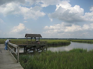
Johns Island is an island in Charleston County, South Carolina, United States, and is the largest island in the state of South Carolina. Johns Island is bordered by the Wadmalaw, Seabrook, Kiawah, Edisto, Folly, and James islands; the Stono and Kiawah rivers separate Johns Island from its border islands. It is the fourth-largest island on the US east coast, surpassed only by Long Island, Mount Desert Island and Martha's Vineyard. Johns Island is 84 square miles (220 km2) in area, with a population of 21,500 people.

West Ashley, or more formally, west of the Ashley, is one of the six distinct areas of the city proper of Charleston, South Carolina. As of March 2020, its estimated population was 82,341. Its name is derived from the fact that the land is west of the Ashley River.

Ashley River Historic District is a historic district located in the South Carolina Lowcountry near Charleston, South Carolina, United States. The Historic District includes land from five municipalities, almost equally split between Charleston and Dorchester counties. The district includes dry land, swamps, and marshes of the Rantowles Creek and Stono Swamp watershed.

The John F. Limehouse Memorial Bridge, located about 15 miles (24 km) west of downtown Charleston, South Carolina, was completed in 2003. It replaced an obsolete low-level swing bridge over the Stono River. The current bridge, which crosses a channel between Johns Island and St. Andrews Parish, an area generally called West Ashley, was completed under a partnership between the South Carolina Department of Transportation (SCDOT) and the United States Coast Guard.
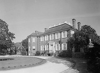
The Fenwick Hall, which is also known as Fenwick Castle, is a plantation house built about 1730 on Johns Island, South Carolina, across the Stono River from James Island and Charleston. It is located between River Road and Penneys Creek. It was named to the National Register of Historic Places on February 23, 1972.
Fort Pemberton was one of the larger confederate forts was constructed in the defense of Charleston, South Carolina during the American Civil War. When Charleston was overwhelmed by Union forces in 1861, it became evident that control of the western regions of James Island and the Stono River was to be an important element in the defense of the city. Confederate military authorities of the time believed that Union occupation of James Island would leave Charleston subject to attack from the southeast. From this position the city would assuredly fall to the Union. Although there were many gun batteries in place along the south and east side of James Island, Fort Pemberton was the only fortress in defense of this region.

Fort Johnson is a state-owned historic site of military and political significance located on the northeast point of James Island in Charleston County, South Carolina.

Battery Gadsden is a historic artillery battery located at Sullivan's Island, Charleston County, South Carolina. It was built in 1903–1904, and is one of a series of batteries stretching from Fort Moultrie to the eastern end of Sullivan's Island. It was named after Christopher Gadsden. Until decommissioned in 1917, the concrete battery housed four, six inch guns. It measures approximately 377 feet long and 84 feet wide, with the front or ocean side of the battery at approximately 7 feet high. Battery Gadsden and its neighbor Battery Thomson provided fortification at the mouth of Charleston Harbor. The battery now houses the Edgar Allan Poe Branch of the Charleston County Public Library.

Battery Thomson is a historic artillery battery located at Sullivan's Island, Charleston County, South Carolina. It was built in 1906–1909, and is one of a series of batteries stretching from Fort Moultrie to the eastern end of Sullivan's Island. Until decommissioned in 1947, the concrete battery housed two, ten inch guns. It measures approximately 326 feet long and 84 feet wide, with the front or ocean side of the battery at approximately 10 feet high. Battery Thomson and its neighbor Battery Gadsden provided fortification at the mouth of Charleston Harbor.
Unnamed Battery No. 1 is a historic artillery battery located at Clark's Point, James Island, Charleston County, South Carolina. It was built in 1862, and was the southern end of the eastern James Island line. At the end of the war this battery mounted two field guns. The earthen redoubt measures approximately 240 feet long and 200 feet wide. It has a 12 foot high parapet wall and a powder magazine about 17 feet in height.

Battery Cheves is a historic artillery battery located at James Island, Charleston, South Carolina. It was built in 1863, and designed to protect the area between Fort Johnson and Battery Haskell. At the end of the war this battery mounted two pieces of heavy artillery. The earthen redoubt measures approximately 280 feet long and 240 feet deep. It has a 12-foot, 6 inch, high parapet wall and a powder magazine about 15 feet in height.
Battery LeRoy is a historic artillery battery located at James Island, Charleston, South Carolina. It was built in 1863, and designed to protect lower James Island. At the end of the war this battery mounted four guns. The earthen redoubt measures approximately 340 feet on its right face, 140 feet on the center face and 160 feet on the left face. It has a 15-foot-high parapet wall and a slightly higher powder magazine.
Battery Tynes is a historic artillery battery located at James Island, Charleston, South Carolina. It was built in 1863, and designed to protect the upper Stono River and the bridge from James Island to Johns Island, South Carolina. The earthen redoubt measures approximately 320 feet long and 180 feet deep. It has a 10–20 foot high parapet wall and a 15 feet high powder magazine.
Battery No. 1 is a historic artillery battery located at James Island, Charleston, South Carolina. It was built in 1863, as part of the James Island Siege Line. At the close of the war it was armed with five pieces of artillery. The earthen redoubt's right face is about 240 feet, the center face approximately 160 feet, and the left face 280 feet in length. It has a 15-foot-high parapet wall and a 20-foot-high powder magazine.
Battery No. 5 is a historic artillery battery located at James Island, Charleston, South Carolina. It was built in 1863, as part of the James Island Siege Line. At the close of the war it was armed with four guns. The earthen redoubt's left faces measuring about 200 feet and the center face about 100 feet. It has a 10 foot high parapet wall.
Fort Trenholm, also known as Battery Trenholm, is a historic artillery battery located at Johns Island, Charleston, South Carolina. It was built in 1864, to reinforce Fort Pringle and protect the Stono River and Johns Island. It has emplacements for 17 guns. The three-sided earthen redoubt measures approximately 870 feet on its eastern face, 780 feet long on its southern face, and 885 feet long on its western face. It has a 15-foot-high parapet wall.
Unnamed Battery is a historic artillery battery located at West Ashley, Charleston, South Carolina. It was built in 1862, to protect the exterior western lines running from the Stono River on the south to the Ashley River at Bee's Ferry. It has emplacements for two guns. It measures approximately 160 feet by 160 feet with a 10-foot parapet and a 15-foot powder magazine.


