Fort Sanders, Knoxville

Last updated

Fort Sanders Historic District
Fort-sanders-neighborhood-pillar-tn1.jpg
USA Tennessee location map.svg
Red pog.svg
Usa edcp location map.svg
Red pog.svg
LocationRoughly bounded by White and Grand Aves. and 11th and 19th Sts.
Knoxville, Tennessee
Coordinates 35°57′37″N83°55′54″W / 35.96028°N 83.93167°W / 35.96028; -83.93167
Areaapproximately 105 acres (42 ha) [1]
Built18801930
Architectmultiple
Architectural styleQueen Anne, Bungalow/Craftsman, Georgian Revival, Italianate
NRHP reference No. 80003839
Added to NRHPSeptember 16, 1980

Fort Sanders is a neighborhood in Knoxville, Tennessee, USA, located west of the downtown area and immediately north of the main campus of the University of Tennessee. Developed in the late 19th century as a residential area for Knoxville's growing upper and middle classes, the neighborhood now provides housing primarily for the university's student population. The neighborhood still contains a notable number of its original Victorian-era houses and other buildings, several hundred of which were added to the National Register of Historic Places in 1980 as the Fort Sanders Historic District.

Contents

Fort Sanders is named for a Civil War-era Union bastion that once stood near the center of the neighborhood, which was the site of a key engagement in 1863. Before the Union occupation of Knoxville began, Fort Sanders was often referred to as “Fort Loudon” by the occupying Confederate troops. [1] In the 1880s, several of Knoxville's wealthier residents built sizeable houses in what is now the southern half of Fort Sanders, then known as "White's Addition," while the northern half, known as "Ramsey's Addition," was developed to provide housing for plant managers and workers employed in factories along Second Creek. Fort Sanders was incorporated as the separate city of West Knoxville in 1888, and was annexed by Knoxville in 1897. In its early years, Fort Sanders residents included some of Knoxville's leading industrialists and politicians, as well as professors from the University of Tennessee.

Fort Sanders was the childhood home of author James Agee, and provided the setting for his Pulitzer Prize-winning novel, A Death in the Family . A ten-fold expansion of U.T.'s student body after World War II brought about the need for student housing, and many of the old homes in Fort Sanders have since been converted into apartments. [1]

Location

Fort Sanders and the University of Tennessee campus straddle a hill that is bounded by Second Creek on the east, Third Creek on the west, the Tennessee River on the south, and a declivity now traversed by the Southern Railway tracks and Interstate 40 on the north. The university occupies the southern half of the hill, overlooking the river, while Fort Sanders occupies the northern half. Cumberland Avenue (part of U.S. Route 70), commonly called "The Strip," is the approximate boundary between the two. Fort Sanders Regional Medical Center occupies the western half of the Fort Sanders neighborhood.

The World's Fair Park, the site of the 1982 World's Fair, lies opposite Second Creek to the east. The Mechanicsville neighborhood lies on the other side of I-40 to the north. West of the L&N tracks, Cumberland Avenue becomes Kingston Pike, which continues into West Knoxville.

History

Battle of Fort Sanders

Fort Sanders, photographed in 1864 Fort-sanders-1864-tn2.jpg
Fort Sanders, photographed in 1864

In November 1863, Confederate forces under General James Longstreet marched north from Chattanooga to Knoxville in hopes of dislodging Union forces under Ambrose Burnside, who had occupied Knoxville a few months prior. After a brief skirmish at Campbell's Station (Farragut), Longstreet's forces approached Knoxville from the west along Kingston Pike. Delaying maneuvers executed by General William P. Sanders gave Union forces in the city time to complete fortifications, although Sanders was mortally wounded on November 18, and died at the Lamar House the following day. With Union fortifications in place, Longstreet decided to surround the city and starve Union forces out. [2]

During the Siege of Knoxville, Confederate pickets stretched roughly along what is now Twenty-First Street between Cumberland and Forest avenues. Union fortifications included Fort Byington atop "The Hill," Battery Noble at what is now the intersection of Melrose and Seventeenth, and Battery Zoellner near the intersection of Highland and Eleventh. Fort Sanders, originally "Fort Loudon" but renamed in honor of the deceased General Sanders by occupying Union forces, was an earthen fort that spanned Seventeenth between Laurel and Clinch, and continued along Laurel and Clinch eastward to Sixteenth Street. [3]

On the morning of November 29, 1863, after a two-week siege, Longstreet ordered three brigades under General Lafayette McLaws to attack Fort Sanders, in hopes of breaching Union lines. [2] The attackers marched from what is now the intersection of Nineteenth and Forest, southeastward across the intersection of Eighteenth and Highland, toward the fort's northeast corner at the intersection of Seventeenth and Laurel. [3] They were unable to overcome a deep trench at the base of the fort, however, and retreated with heavy casualties. The battle, which lasted just twenty minutes, effectively ended Longstreet's chances of taking the city, and he retreated shortly afterward. [2]

Early development

White's Addition, as it appeared on an 1886 map of Knoxville Whites-addition-1886-tn1.jpg
White's Addition, as it appeared on an 1886 map of Knoxville

Knoxville's industrial growth after the Civil War led to a rapid increase in the city's population. During the 1880s, pollution from an ore smelting operation drove residents in the upscale Summit Hill area to seek new homes elsewhere. [1] Several chose the hillslope west of Second Creek known as White's Addition (after Hugh Lawson White, who once owned a house in the area), which stretched from the Tennessee River to what is now Laurel Avenue. Among the earliest to build mansions in White's Addition were candy manufacturer Martin Luther Ross and Tennessee attorney general George Pickle. [1]

During the same period, a number of factories sprang up along Second Creek, and the area known as Ramsey's Addition, which stretched northward from what is now Laurel Avenue to the railroad tracks, developed primarily as housing for factory managers and workers. Unlike the more exclusive White's Addition, residents in Ramsey's Addition ranged from wage workers to upper-level managers, and the neighborhood had a mix of houses ranging from impressive Victorian mansions to small, inconspicuous shotgun-style houses. [1]

House on Laurel Avenue, built by candy manufacturer Martin Luther Ross in 1894 Laurel-terrace-knoxville-tn1.jpg
House on Laurel Avenue, built by candy manufacturer Martin Luther Ross in 1894

An 1886 map of Knoxville shows development in the Fort Sanders area stretching as far west as what is now Seventeenth Street. The University of Tennessee consisted of several buildings clustered around "The Hill." Factories located along Second Creek included the Knoxville Tannery, the Caswell Furniture Company, the Knoxville Ice Company, the Barker Bucket Factory, the Knoxville Button Factory, and the massive foundry of the Knoxville Iron Company (part of which still stands). The Samuels Keg Factory and the Knoxville Woolen Mills were located along the railroad tracks at the north end of Ramsey's Addition. [4]

With a need for city services, and bureaucratic issues preventing annexation by Knoxville, the Fort Sanders area incorporated as the separate city of West Knoxville on March 8, 1888. The city's boundaries were Second Creek on the east, Asylum (now Western) Avenue and the railroad tracks on the north, Third Creek on the west, and the river on the south. West Knoxville had an initial population of 1,520, and J.W. Yoe served as the first mayor. [5] West Knoxville was annexed by Knoxville in 1897. Today, "West Knoxville" generally refers to the section of Knoxville along Kingston Pike, west of Third Creek and Alcoa Highway.

Later development

The Roddy House on Clinch Avenue, built circa 1912 1803-clinch-knoxville-tn1.jpg
The Roddy House on Clinch Avenue, built circa 1912

During the late nineteenth and early twentieth centuries, Fort Sanders was home to some of Knoxville's key industrial figures. Department store owner Max Arnstein, who built the seven-story Arnstein Building at the south end of Market Square, owned houses at 1403 and 1625 Laurel. Wholesaling tycoon Matthew McClung, a partner in Cowan, McClung and Company, built the house at 1625 Clinch. Marble quarry magnate John J. Craig lived at 1415 Highland, and Coca-Cola bottler J. Patrick Roddy lived at 1803 Clinch. Knoxville Journal founder and editor William Rule lived at 1604 Clinch. [1] Ranson Whittle, the founder of the Whittle Trunk and Bag Company, lived at 1802 Highland. [6]

Fort Sanders was also home to a number early University of Tennessee professors and administrators. Weston Fulton, inventor of the sylphon (used in the manufacture of thermostats), lived at 1202 Clinch in the early 1900s. William Waller Carson, founder of the school's civil engineering department, lived at 1310 Clinch, and later built what is now the Ronald McDonald House at 1705 Clinch. Thomas Jordan, the school's dean in the early 1900s, lived at 1312 White, and mathematics professor Cooper D. Schmitt lived at 1302 White. [1] Schmitt's son, Pulitzer Prize-winning historian Bernadotte Everly Schmitt, lived in the house as a child. [6] Artist Catherine Wiley lived at 1317 White in the 1910s while working as an instructor at UT. [7]

With the advent of the automobile in the 1920s, Knoxville's wealthier residents began to move to suburbs on the periphery of the city, and urban neighborhoods such as Fort Sanders began to decline. After World War II, the University of Tennessee's student body grew from just over 2,000 to almost 30,000 by 1975, and most of the homes in Fort Sanders were converted into student housing. The university's expansion (and more recently the expansion of Fort Sanders Regional Medical Center) led to the destruction of many of the neighborhood's early houses, and preservationists, namely the Fort Sanders Community Improvement Association, increased efforts to protect its historical resources. [1]

A Death in the Family

James Agee Park on Laurel James-agee-park-knoxville-tn1.jpg
James Agee Park on Laurel

Author James Agee (19091955) spent his early childhood in the Fort Sanders neighborhood. The Agees initially lived at 1505 Highland Avenue (the house is no longer standing), but moved to Laurel Avenue after the death of Agee's father in 1915. Agee's maternal grandparents, Joel and Emma Tyler, lived on Clinch Avenue. Joel Tyler was a cofounder of the mill machinery company Ty-Sa-Man, where Agee's father worked. [8]

The Fort Sanders neighborhood provides the primary setting for Agee's Pulitzer Prize-winning novel, A Death in the Family. The novel opens with Agee and his father taking a walk through downtown Knoxville, making stops on Gay Street and Market Square, and passing the Deaf and Dumb Asylum and the L&N Station as they made their way back to Fort Sanders. Agee mentioned a vacant lot along Forest Avenue where he and his father liked to look out on the lights of North Knoxville in the distance, and listen to the engines of the L&N, which "coughed and browsed" in the valley below. [9] The book ends with Agee and his uncle conversing while standing over the "waste of briers and of embanked clay" of the ruins of the Civil War-era Fort Sanders. [10]

In 1999, Fifteenth Street was renamed "James Agee Street." [11] In 2005, James Agee Park was established in a vacant lot (formerly the home of Mayor Samuel B. Luttrell) at the intersection of James Agee Street and Laurel Avenue. [12]

Fort Sanders today

Fort Sanders, or "The Fort" as it is known by residents, remains a popular place for students. Most residents are in their twenties and many go home during the summer, leaving the neighborhood virtually empty compared to its very active, and sometimes belligerent, feel during the school year. Due to the area's younger population and proximity to a large university, the neighborhood is a hotbed for house parties and bars alike. The neighborhood is somewhat infamous in Knoxville for its party atmosphere, and residents have been known to throw multi-street block parties that can attract thousands. The biggest being on October 15, 2022, which was the night the Vols broke a 15-year losing streak to Alabama beating the Crimson Tide 52–49. The block of 13th and Laurel Ave was filled to the brim with people as they lit couches on fire listening to Dixieland Delight. Cumberland Avenue, or "The Strip", is a popular hangout for students, as it contains numerous bars, restaurants, and stores.

During the Fall football season, Fort Sanders, along with the campus itself, serves as a headquarters for Tennessee Volunteers fans' tailgating and pre-game activities.

The Knoxville Police Department and The University of Tennessee's Police Department jointly patrol Fort Sanders. The university operates a fully armed and operational police that helps protect students both on campus and in Fort Sanders.

Fort Sanders Historic District

Christ Chapel, formerly the Epworth Methodist Church 1538-highland-knoxville-tn1.jpg
Christ Chapel, formerly the Epworth Methodist Church

The Fort Sanders Historic District, listed on the National Register in 1980, originally consisted of approximately 400 buildings, and covered a 105-acre (42 ha) area bounded by White, Grand, Eleventh, and Nineteenth. Most of the district's contributing houses were built between 1880 and 1930, and the majority were designed in Victorian (especially Queen Anne) or Bungalow/Craftsman styles. The district also includes three churches and several commercial buildings. [1]

Notable structures

Firedog Pizza/Deli Market on Thirteenth Street 310-thirteenth-street-knoxville-tn1.jpg
Firedog Pizza/Deli Market on Thirteenth Street

Related Research Articles

<span class="mw-page-title-main">Knoxville, Tennessee</span> City in Tennessee, United States

Knoxville is a city in and the county seat of Knox County, Tennessee, United States. As of the 2020 United States census, Knoxville's population was 190,740, making it the largest city in the East Tennessee Grand Division and the state's third-most-populous city after Nashville and Memphis. It is the principal city of the Knoxville metropolitan area, which had a population of 879,773 in 2020.

<span class="mw-page-title-main">Lenoir City, Tennessee</span> City in Tennessee, United States

Lenoir City is a suburban city located in Loudon County, Tennessee. The population was 10,117 at the 2020 census. It is included in the Knoxville metropolitan area in East Tennessee, along the Tennessee River southwest of Knoxville.

<span class="mw-page-title-main">Battle of Fort Sanders</span> 1863 American Civil War battle

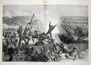
The Battle of Fort Sanders was the crucial engagement of the Knoxville Campaign of the American Civil War, fought in Knoxville, Tennessee, on November 29, 1863. Assaults by Confederate Lt. Gen. James Longstreet failed to break through the defensive lines of Union Maj. Gen. Ambrose Burnside, resulting in lopsided casualties, and the Siege of Knoxville entered its final days.

<span class="mw-page-title-main">Siege of Knoxville</span> 1863 American Civil War battle

The siege of Knoxville saw Lieutenant General James Longstreet's Confederate forces besiege the Union garrison of Knoxville, Tennessee, led by Major General Ambrose Burnside. When Major General William T. Sherman approached Knoxville with an overwhelming Union force, Longstreet ended the siege on December 4 and withdrew northeast. The siege was part of the Knoxville campaign of the American Civil War.

<span class="mw-page-title-main">Mechanicsville, Knoxville</span> United States historic place

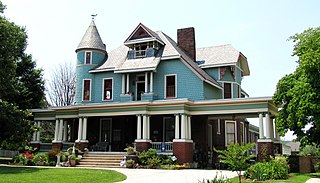
Mechanicsville is a neighborhood in Knoxville, Tennessee, United States, located northwest of the city's downtown area. One of the city's oldest neighborhoods, Mechanicsville was established in the late 1860s for skilled laborers working in the many factories that sprang up along Knoxville's periphery. The neighborhood still contains a significant number of late-19th-century Victorian homes, and a notable concentration of early-20th-century shotgun houses. In 1980, several dozen properties in Mechanicsville were added to the National Register of Historic Places as the Mechanicsville Historic District. The neighborhood was also designated as a local historic district in 1991, subject to historic zoning and design standards.

<span class="mw-page-title-main">Knoxville campaign</span> 1863 campaign in the American Civil War

The Knoxville campaign was a series of American Civil War battles and maneuvers in East Tennessee during the fall of 1863 designed to secure control of the city of Knoxville and with it the railroad that linked the Confederacy east and west, and position the First Corps under Longstreet for return to the Army of Northern Virginia. Union Army forces under Maj. Gen. Ambrose Burnside occupied Knoxville, Tennessee, and Confederate States Army forces under Lt. Gen. James Longstreet were detached from Gen. Braxton Bragg's Army of Tennessee at Chattanooga to prevent Burnside's reinforcement of the besieged Federal forces there. Ultimately, Longstreet's Siege of Knoxville ended when Union Maj. Gen. William Tecumseh Sherman led elements of the Army of the Tennessee and other troops to Burnside's relief after Union troops had broken the Confederate siege of Chattanooga. Although Longstreet was one of Gen. Robert E. Lee's best corps commanders in the East in the Army of Northern Virginia, he was unsuccessful in his attempt to penetrate the Knoxville defenses and take the city.

<span class="mw-page-title-main">Old City, Knoxville</span> United States historic place

The Old City is a neighborhood in Knoxville, Tennessee, United States, located at the northeast corner of the city's downtown area. Originally part of a raucous and vice-ridden section of town known as "The Bowery," the Old City has since been revitalized through extensive redevelopment efforts carried out during the 1980s through the present. Currently, the Old City is an offbeat urban neighborhood, home to several unique restaurants, bars, clubs, and shops.

<span class="mw-page-title-main">Craighead–Jackson House</span> Historic house in Tennessee, United States

The Craighead–Jackson House is a historic two-story, brick house in Knoxville, in the U.S. state of Tennessee. The home was constructed by John Craighead in 1818 across the street from the William Blount Mansion. The house is on the National Register of Historic Places.

<span class="mw-page-title-main">Kingston Pike</span> Highway in Tennessee, U.S.

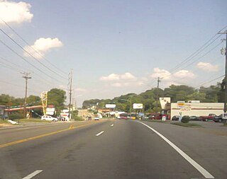
Kingston Pike is a highway in Knox County, Tennessee, United States, that connects Downtown Knoxville with West Knoxville, Farragut, and other communities in the western part of the county. The road follows a merged stretch of U.S. Route 11 (US 11) and US 70. From its initial construction in the 1790s until the development of the Interstate Highway System in the 1960s, Kingston Pike was the main traffic artery in western Knox County, and an important section of several cross-country highways. The road is now a major commercial corridor, containing hundreds of stores, restaurants, and other retail establishments.

<span class="mw-page-title-main">First Corps, Army of Northern Virginia</span> Military unit

The First Corps, Army of Northern Virginia (or Longstreet's Corps) was a military unit fighting for the Confederate States of America in the American Civil War. It was formed in early 1861 and served until the spring of 1865, mostly in the Eastern Theater. The corps was commanded by James Longstreet for most of its existence.

<span class="mw-page-title-main">Old North Knoxville</span> Neighborhood in Knoxville, Tennessee, United States

Old North Knoxville is a neighborhood in Knoxville, Tennessee, United States, located just north of the city's downtown area. Initially established as the town of North Knoxville in 1889, the area was a prominent suburb for Knoxville's upper middle and professional classes until the 1950s. After a period of decline, preservationists began restoring many of the neighborhood's houses in the 1980s. In 1992, over 400 houses and secondary structures in the neighborhood were added to the National Register of Historic Places as the Old North Knoxville Historic District.

<span class="mw-page-title-main">South Knoxville</span>

South Knoxville is the section of Knoxville, Tennessee, United States, that lies south of the Tennessee River. It is concentrated along Chapman Highway, Alcoa Highway, Maryville Pike, Sevierville Pike, and adjacent roads, and includes the neighborhoods of Lindbergh Forest, Island Home Park, Old Sevier, South Haven, Vestal, Lake Forest, South Woodlawn and Colonial Village. South Knoxville is connected to Downtown Knoxville via four vehicle bridges: the James C. Ford Memorial Bridge, the Gay Street Bridge, the Henley Bridge, by some incorrectly called the Henley Street Bridge, and the J. E. "Buck" Karnes Bridge. Parts of South Knoxville were annexed by Knoxville in 1917.

West Knoxville is a section of Knoxville, Tennessee, US. It is west of the city's downtown area. It stretches from Sequoyah Hills on the east to the city's border with Farragut on the west. West Knoxville is concentrated around Kingston Pike (US-70/US-11), and along with Sequoyah Hills includes the neighborhoods of Lyons View, Forest Hills, Bearden, West Hills, Westmoreland Heights, Cedar Bluff, and Ebenezer.

East Knoxville is the section of Knoxville, Tennessee, USA, that lies east of the city's downtown area. It is concentrated along Magnolia Avenue (US-70/US-11), Martin Luther King, Jr., Boulevard, Dandridge Avenue, and adjacent streets, and includes the neighborhoods of Holston Hills, Parkridge, Chilhowee Park, Morningside, Five Points, and Burlington. East Knoxville is home to Zoo Knoxville, the Knoxville Botanical Garden and Arboretum, and Chilhowee Park.

<span class="mw-page-title-main">Downtown Knoxville</span> Central business district and neighborhood in Knoxville, Tennessee, United States

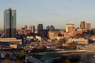
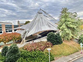
Downtown Knoxville is the downtown area of Knoxville, Tennessee, United States. It contains the city's central business district and primary city and county municipal offices. It is also home to several retail establishments, residential buildings, the city's convention center, and World's Fair Park. The downtown area contains the oldest parts of Knoxville, and is home to the city's oldest buildings.

<span class="mw-page-title-main">Fourth and Gill, Knoxville</span> Historic house in Tennessee, United States

Fourth and Gill is a neighborhood in Knoxville, Tennessee, United States, located north of the city's downtown area. Initially developed in the late nineteenth century as a residential area for Knoxville's growing middle and professional classes, the neighborhood still contains most of its original Victorian-era houses, churches, and streetscapes. In 1985, 282 houses and other buildings in the neighborhood were added to the National Register of Historic Places as the Fourth and Gill Historic District.

<span class="mw-page-title-main">Lonsdale, Knoxville, Tennessee</span> Neighborhood in Knoxville, Tennessee

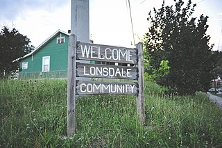
Lonsdale is a neighborhood in Knoxville, Tennessee, United States, located northwest of the city's downtown area. Established in the late-19th century as a land development project, Lonsdale incorporated as a separate city in 1907, and was annexed by Knoxville in 1917. After a period of decline in the latter half of the 20th century, Lonsdale has recently undergone several major revitalization efforts.

<span class="mw-page-title-main">Parkridge, Knoxville</span> United States historic place

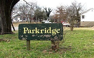
Parkridge is a neighborhood in Knoxville, Tennessee, United States, located off Magnolia Avenue east of the city's downtown area. Developed as a streetcar suburb for Knoxville's professional class in the 1890s, the neighborhood was incorporated as the separate city of Park City in 1907, and annexed by Knoxville in 1917. In the early 1900s, the neighborhood provided housing for workers at the nearby Standard Knitting Mill factory.

<span class="mw-page-title-main">Gay Street (Knoxville)</span> United States historic place

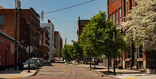
Gay Street is a street in Knoxville, Tennessee, United States, that traverses the heart of the city's downtown area. Since its development in the 1790s, Gay Street has served as the city's principal financial and commercial thoroughfare, and has played a primary role in the city's historical and cultural development. The street contains Knoxville's largest office buildings and oldest commercial structures. Several buildings on Gay Street have been listed on the National Register of Historic Places.

<span class="mw-page-title-main">History of Knoxville, Tennessee</span>

The History of Knoxville, Tennessee, began with the establishment of James White's Fort on the Trans-Appalachian frontier in 1786. The fort was chosen as the capital of the Southwest Territory in 1790, and the city, named for Secretary of War Henry Knox, was platted the following year. Knoxville became the first capital of the State of Tennessee in 1796, and grew steadily during the early 19th century as a way station for westward-bound migrants and as a commercial center for nearby mountain communities. The arrival of the railroad in the 1850s led to a boom in the city's population and commercial activity.

References

  1. 1 2 3 4 5 6 7 8 9 10 11 12 13 14 15 16 17 Don Akchin and Lisa Akchin, National Register of Historic Places Nomination Form for Fort Sanders Historic District, March 4, 1980.
  2. 1 2 3 Robert McKenzie, Lincolnites and Rebels: A Divided Town in the American Civil War (New York: Oxford University Press, 2006), 166-171.
  3. 1 2 Digby Gordon Seymour, Divided Loyalties: Fort Sanders and the Civil War in East Tennessee (Knoxville, Tenn.: University of Tennessee Press, 1963), p. 189.
  4. Henry Wellge, Knoxville, Tenn.: County Seat of Knox County, 1886 (Milwaukee: Norris, Wellge and Company, 1886). Map.
  5. John Wooldridge, George Mellen, William Rule (ed.), Standard History of Knoxville, Tennessee (General Books, 2009), pp. 92-94.
  6. 1 2 3 4 5 Fort Sanders Neighborhood Archived November 30, 2013, at the Wayback Machine , Knox Heritage Fragile Fifteen, 2013. Retrieved: May 15, 2013.
  7. University of Tennessee Register, Vol. 17, No. 2 (April 1914), p. 15.
  8. Laurence Bergreen, James Agee: A Life (New York: Dutton, 1984), pp. 5-9.
  9. James Agee, A Death in the Family (New York: McDowell, Obolensky, 1957), pp. 16-18.
  10. A Death in the Family, p. 337.
  11. James Agee Park History Archived June 13, 2010, at the Wayback Machine . Retrieved: September 1, 2010.
  12. UT to Host James Agee Celebration Archived July 18, 2011, at the Wayback Machine . April 1, 2005. Retrieved: September 1, 2010.
  13. A Brief History of the Christ Chapel Building. Retrieved: September 1, 2010.
  14. About Knoxville's Ronald McDonald House Archived July 29, 2010, at the Wayback Machine . Retrieved: September 1, 2010.
  15. Megan Boehnke, "UT Begins Buying Victorian Houses to Make Way for New Science Building," Knoxville News Sentinel, August 27, 2013. Retrieved: August 27, 2013.