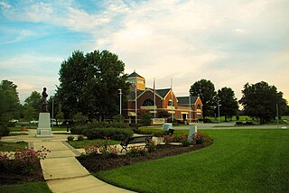
Farragut is a suburban town located in Knox and Loudon counties in the State of Tennessee, United States. The town's population was 23,506 at the 2020 census. It is included in the Knoxville Metropolitan Area. The town is named in honor of Union Admiral David Farragut, who was born just east of Farragut at Campbell's Station in 1801, and fought in the American Civil War.
Antioch is a neighborhood of Nashville located approximately 12 miles southeast of Downtown Nashville. It is served by the Metropolitan Government of Nashville and Davidson County.

Weigel's is a convenience store chain based in Powell, Tennessee with 68 locations in the East Tennessee region. They also own and operate Broadacre Dairy Inc, which processes milk, tea, juices, and eggnog for their convenience stores, as well as its own bakery, Red Barn Foods.

Sequoyah Hills is a neighborhood in Knoxville, Tennessee, United States, named for the Cherokee scholar Sequoyah, inventor of the Cherokee alphabet. It is located off Kingston Pike, between the city's downtown and West Knoxville. Initially developed in the 1920s, Sequoyah Hills was one of Knoxville's first suburbs and today is home to some of the city's most affluent residents. The neighborhood contains numerous notable examples of mid-20th century residential architecture, with houses designed by architects such as Charles I. Barber, Benjamin McMurry, and Francis Keally.

Wawa is an unincorporated community located in Delaware County, in the U.S. state of Pennsylvania in Greater Philadelphia, partially in Middletown Township and partially in Chester Heights Borough.
Concord is an unincorporated community in Knox County, Tennessee, United States and is listed on the National Register of Historic Places as a historic district, the Concord Village Historic District. The United States Geographic Names Information System classifies Concord as a populated place. It is located in western Knox County, east of Farragut and west of Knoxville. Mail destined for Concord is now addressed to Concord, Knoxville, or Farragut.
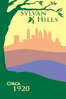
Sylvan Hills is a historic intown neighborhood in southwest Atlanta, Georgia, United States.

Morningside/Lenox Park is an intown neighborhood in Atlanta, Georgia founded in 1923. It is located north of Virginia-Highland, east of Ansley Park and west of Druid Hills. Approximately 3,500 households comprise the neighborhood that includes the original subdivisions of Morningside, Lenox Park, University Park, Noble Park, Johnson Estates and Hylan Park.
This is a list of the National Register of Historic Places listings in Knox County, Tennessee.

West Town Mall is a shopping mall located in Knoxville, Tennessee, United States. Opened in August 1972, this one-level mall is located in the western portion of Knoxville in the West Hills community. West Town Mall is located along Interstates 40/75 and Kingston Pike. The mall has 1,339,000 square feet (124,397 m2) of gross leasable area, making it the largest of any enclosed shopping mall in Tennessee. The anchor stores are Dillard's, Dick's House of Sport, 2 Belk stores, JCPenney, and Cinebarre.

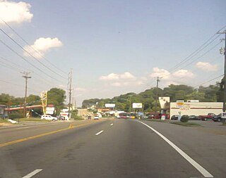
Kingston Pike is a highway in Knox County, Tennessee, United States, that connects Downtown Knoxville with West Knoxville, Farragut, and other communities in the western part of the county. The road follows a merged stretch of U.S. Route 11 (US 11) and US 70. From its initial construction in the 1790s until the development of the Interstate Highway System in the 1960s, Kingston Pike was the main traffic artery in western Knox County, and an important section of several cross-country highways. The road is now a major commercial corridor, containing hundreds of stores, restaurants, and other retail establishments.
Edenridge is an unincorporated community in New Castle County, Delaware, United States in the Brandywine Hundred, north of Wilmington.

Woodbrook is a suburban community in New Castle County, Delaware, United States.
South Knoxville is the section of Knoxville, Tennessee, United States, that lies south of the Tennessee River. It is concentrated along Chapman Highway, Alcoa Highway, Maryville Pike, Sevierville Pike, and adjacent roads, and includes the neighborhoods of Lindbergh Forest, Island Home Park, Old Sevier, South Haven, Vestal, Lake Forest, South Woodlawn and Colonial Village. South Knoxville is connected to Downtown Knoxville via four vehicle bridges: the James C. Ford Memorial Bridge, the Gay Street Bridge, the Henley Bridge, by some incorrectly called the Henley Street Bridge, and the J. E. "Buck" Karnes Bridge. Parts of South Knoxville were annexed by Knoxville in 1917.
West Knoxville is a section of Knoxville, Tennessee, US. It west of the city's downtown area. It stretches from Sequoyah Hills on the east to the city's border with Farragut on the west. West Knoxville is concentrated around Kingston Pike (US-70/US-11), and along with Sequoyah Hills includes the neighborhoods of Lyons View, Forest Hills, Bearden, West Hills, Westmoreland Heights, Cedar Bluff, and Ebenezer.
North Knoxville is the section of Knoxville, Tennessee, USA, that lies north of the city's downtown area. It is concentrated around Broadway (US-441), Clinton Highway (US-25W), Tazewell Pike (TN-331), Washington Pike, and adjacent roads, and includes the neighborhoods of Fountain City, Inskip-Norwood, Oakwood-Lincoln Park, Old North Knoxville, Fourth and Gill, North Hills, and Whittle Springs. North Knoxville is bisected by Sharp's Ridge, a 7-mile (11 km) elongate ridge that rises prominently above the surrounding terrain.

Bearden, also known as Bearden Village, is a neighborhood in Knoxville, Tennessee, United States, located along Kingston Pike in West Knoxville. Developed primarily as an agrarian community in the 19th century, this neighborhood now lies at the heart of one of Knoxville's major commercial corridors. Named for former Knoxville mayor and Tennessee state legislator, Marcus De Lafayette Bearden (1830–1885), the community was annexed by Knoxville in 1962.
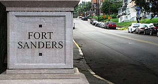
Fort Sanders is a neighborhood in Knoxville, Tennessee, USA, located west of the downtown area and immediately north of the main campus of the University of Tennessee. Developed in the late 19th century as a residential area for Knoxville's growing upper and middle classes, the neighborhood now provides housing primarily for the university's student population. The neighborhood still contains a notable number of its original Victorian-era houses and other buildings, several hundred of which were added to the National Register of Historic Places in 1980 as the Fort Sanders Historic District.
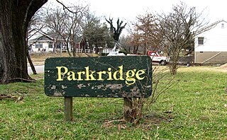
Parkridge is a neighborhood in Knoxville, Tennessee, United States, located off Magnolia Avenue east of the city's downtown area. Developed as a streetcar suburb for Knoxville's professional class in the 1890s, the neighborhood was incorporated as the separate city of Park City in 1907, and annexed by Knoxville in 1917. In the early 1900s, the neighborhood provided housing for workers at the nearby Standard Knitting Mills factory.
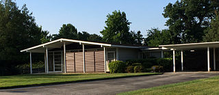
Cumberland Estates is a residential neighborhood in the City of Knoxville, Tennessee, United States, which gained national attention for architectural innovation and research housing in the mid-20th century. It began 2.1 miles outside the city limits, in Knox County, as one of many planned suburban neighborhoods in the post-World War II economic expansion. The development soon attracted an innovative young architect and national sponsors who would create new ways to rapidly and affordably fill the demand for residential housing needs for America’s growing population of families. Their prominent work in the neighborhood influenced the evolution of residential building design. While the attention received from the research homes waned in the last century, the neighborhood has maintained its residential character with few changes while avoiding commercial encroachment and blight.
