Related Research Articles
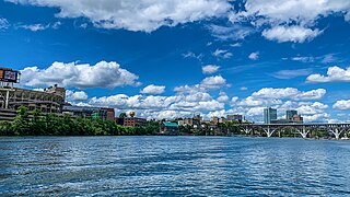
Knoxville is a city in and the county seat of Knox County, Tennessee, United States. As of the 2020 United States census, Knoxville's population was 190,740, making it the largest city in the East Tennessee Grand Division and the state's third largest city after Nashville and Memphis. It is the principal city of the Knoxville metropolitan area, which had a population of 879,773 in 2020.

Lenox Square is a shopping mall in the Buckhead district of Atlanta, Georgia. With 198 tenants and 1,558,678 square feet (144,805.9 m2) of gross leasable area, it is the third-largest mall in Georgia. The mall is currently owned and managed by Simon Property Group, and is considered a sister mall to the adjacent, Simon-owned Phipps Plaza. The mall features Macy's, Bloomingdale's, and Neiman Marcus.
Halls Crossroads is a census-designated place in northern Knox County, Tennessee. As a northern suburb of nearby Knoxville, Halls is included in the Knoxville Metropolitan Statistical Area. The town takes its name from the Thomas Hall family that settled in the area in the late 18th century.

Interstate 640 (I-640) is an east–west auxiliary Interstate Highway in Knoxville, Tennessee. It serves as a bypass for I-40 around Downtown Knoxville and is also an alternative route for traffic passing between I-40 and I-75. All trucks carrying hazardous cargo through Knoxville are required to use I-640. It has a total length of 10.80 miles (17.38 km) and runs approximately three miles (4.8 km) north of downtown through the northern neighborhoods of Knoxville.

Dubai Marina, aka Marsa Dubai, is a district in Dubai, United Arab Emirates. It is an artificial canal city built along a 3-kilometre (2 mi) stretch of the Persian Gulf shoreline. As of 2018, it has a population of 55,052. When the entire development is complete, it will accommodate more than 120,000 people in residential towers and villas. It is located on Interchange 5 between Jebel Ali Port and the area which hosts Dubai Internet City, Dubai Media City, and the American University in Dubai. The first phase of this project has been completed. Dubai Marina was inspired by the Concord Pacific Place development along False Creek in Vancouver, BC, Canada.

Powell, formerly known as Powell Station, is a census-designated place in Knox County, Tennessee. The area is located in the Emory Road corridor, just north of Knoxville, southeast of Clinton, and east of Oak Ridge. It had a population of 13,802 during the 2020 census. It is included in the Knoxville, TN Metropolitan Statistical Area.
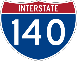
The Pellissippi Parkway is a major highway in Knox and Blount counties in the Knoxville metropolitan area in Tennessee that extends 19.75 miles (31.78 km) from State Route 62 at Solway to SR 33 in Alcoa. It provides access to the cities of Oak Ridge and Maryville from Interstates 40 and 75 in the western part of Knoxville and also serves a major corridor that includes Oak Ridge National Laboratory, Y-12 National Security Complex, and a number of science and technology firms. The central portion of the Pellissippi Parkway is included in the Interstate Highway System and is designated Interstate 140 (I-140), while the remainder is designated as State Route 162. The entire highway is part of the National Highway System, a national network of roads identified as important to the national economy, defense, and mobility. It takes its name from an older name for the Clinch River of Native American origin.
Concord is an unincorporated community in Knox County, Tennessee, United States and is listed on the National Register of Historic Places as a historic district, the Concord Village Historic District. The United States Geographic Names Information System classifies Concord as a populated place. It is located in western Knox County, east of Farragut and west of Knoxville. Mail destined for Concord is now addressed to Concord, Knoxville, or Farragut.
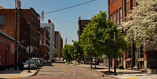
The Old City is a neighborhood in Knoxville, Tennessee, United States, located at the northeast corner of the city's downtown area. Originally part of a raucous and vice-ridden section of town known as "The Bowery," the Old City has since been revitalized through extensive redevelopment efforts carried out during the 1980s through the present. Currently, the Old City is an offbeat urban neighborhood, home to several unique restaurants, bars, clubs, and shops.

Kingston Pike is a highway in Knox County, Tennessee, United States, that connects Downtown Knoxville with West Knoxville, Farragut, and other communities in the western part of the county. The road follows a merged stretch of U.S. Route 11 (US 11) and US 70. From its initial construction in the 1790s until the development of the Interstate Highway System in the 1960s, Kingston Pike was the main traffic artery in western Knox County, and an important section of several cross-country highways. The road is now a major commercial corridor, containing hundreds of stores, restaurants, and other retail establishments.

State Route 131 is a south-to-north highway in the U.S. state of Tennessee that is 68.8 miles long. It is designated as a secondary route.

Strawberry Plains is an unincorporated community and census-designated place (CDP) in Jefferson, Knox, and Sevier counties in the State of Tennessee, United States. Before 2010, it was treated by the United States Census Bureau as a census county division. It is included in both the Knoxville Metropolitan Statistical Area and the Morristown Metropolitan Statistical Area.

Interstate 75 (I-75) in the US state of Tennessee runs from Chattanooga to Jellico by way of Knoxville. I-75 enters the East Tennessee region from Georgia, following the Tennessee Valley all the way through Knoxville to near Rocky Top, then climbs into the Cumberland Mountains before crossing over into Kentucky at Jellico.
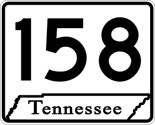
State Route 158 (SR 158) is a major east–west state highway in the city of Knoxville in the U.S. state of Tennessee. It runs 4.63 miles (7.45 km) from Kingston Pike (US 11/US 70) along the Tennessee River to Interstate 40. The western portion of the highway is a surface street known as Neyland Drive and the eastern part is a controlled-access highway called James White Parkway. The entire highway serves as a bypass of downtown Knoxville and as a direct connector to the University of Tennessee (UT) campus and athletic facilities. Serving as the primary means of access to facilities such as Neyland Stadium and Thompson–Boling Arena, the route experiences congestion on game days, with a contraflow lane reversal implemented to mitigate this. It also serves as a spur into downtown and provides access to a number of local landmarks and historic sites, including the Blount Mansion and James White's Fort.

Forrestal Village is a 720,000-square-foot (67,000 m2), 52-acre (210,000 m2) mixed-use retail and office complex in Plainsboro Township, Middlesex County, New Jersey, along Route 1. Despite being in Plainsboro it has a Princeton address. It is just north of Princeton University's Forrestal campus and is named for James Forrestal. The center is anchored by Can Do Fitness and a Westin hotel. In recent years, it has suffered a sharp decline, turning into a dead mall. Renovations and rebranding as an "office" complex are underway to bring customers back. The center has spawned some development in the area, including an adjacent office complex and several apartment and condo communities, including Princeton Windrows, which is right across the street.

U.S. Route 129 is a north–south United States highway that runs for 52.8 miles (85.0 km) in East Tennessee, from the North Carolina state line, near Tapoco, to Knoxville. In Tennessee, the highway is completely overlapped by unsigned State Route 115. In the Greater Knoxville area, US 129 serves as a six-lane controlled-access highway known as Alcoa Highway.

Bearden, also known as Bearden Village, is a neighborhood in Knoxville, Tennessee, United States, located along Kingston Pike in West Knoxville. Developed primarily as an agrarian community in the 19th century, this neighborhood now lies at the heart of one of Knoxville's major commercial corridors. Named for former Knoxville mayor and Tennessee state legislator, Marcus De Lafayette Bearden (1830–1885), the community was annexed by Knoxville in 1962.
The Pinnacle is a 240-acre (97 ha) shopping center and commercial development located in Bristol, Tennessee. Established by Johnson Commercial Development and Oldacre McDonald LLC, its first stores opened in 2014. It is a mixed-use complex, with 1.3 million square feet of retail, restaurant, hotel, and office space, as well as recreational areas. The Pinnacle is located off of U.S. Route 11W and Interstate 81. It is adjacent to the Virginia state line and is near the twin city of Bristol, Virginia.

A power center or big-box center is a shopping center with typically 250,000 to 600,000 square feet of gross leasable area that usually contains three or more big box anchor tenants and various smaller retailers, where the anchors occupy 75–90% of the total area.
Thorn Grove is an unincorporated community in eastern Knox County, Tennessee, United States. It is located 15.4 miles (24.8 km) east of Knoxville and 2 miles (3.2 km) north of Midway. It is included in the Knoxville Metropolitan Statistical Area.
References
- ↑ Bruce Wheeler, Knoxville, Tennessee: A Mountain City in the New South (Knoxville, Tenn.: University of Tennessee Press, 2005), pp. 135, 139, 142, 153, 201.
- ↑ "FAQ". Turkey Creek official website. Archived from the original on December 23, 2009. Retrieved July 23, 2013.
- ↑ Colonial Pinnacle at Turkey Creek, International Council of Shopping Centers. Accessed December 2, 2007.
- ↑ Pavilions of Turkey Creek I & II, International Council of Shopping Centers. Accessed December 2, 2007.
- ↑ City of Knoxville - Turkey Creek Greenway
- 1 2 Harris, Roger (May 15, 2006). "Gobbled Up". Knoxville News Sentinel . Archived from the original on October 25, 2008.