
Norris is a city in Anderson County, Tennessee. Its population was 1,599 at the 2020 census. It is included in the Knoxville, TN Metropolitan Statistical Area.

Knoxville is a city in and the county seat of Knox County, Tennessee, United States, on the Tennessee River. As of the 2020 United States census, Knoxville's population was 190,740, making it the largest city in the East Tennessee Grand Division and the state's third-most-populous city after Nashville and Memphis. It is the principal city of the Knoxville metropolitan area, which had a population of 879,773 in 2020.
"Rocky Top" is an American country and bluegrass song written by Felice and Boudleaux Bryant in 1967 and first recorded by the Osborne Brothers later that same year. The song, which is a city dweller's lamentation over the loss of a simpler and freer existence in the hills of Tennessee, is one of Tennessee's eleven official state songs and has been recorded by dozens of artists from multiple musical genres worldwide since its publication. In U.S. college athletics, "Rocky Top" is associated with the Tennessee Volunteers of the University of Tennessee (UT), whose Pride of the Southland Band has played a marching band version of the song at the school's sporting events since the early 1970s.

Weigel's is a convenience store chain based in Powell, Tennessee with 68 locations in the East Tennessee region. They also own and operate Broadacre Dairy Inc, which processes milk, tea, juices, and eggnog for their convenience stores, as well as its own bakery, Red Barn Foods.

U.S. Route 11W (US 11W) is the western branch of US 11 from the twin cities of Bristol, Tennessee/Bristol, Virginia, where US 11 splits into US 11E and US 11W, to Knoxville, Tennessee, where the two highways rejoin. The highway serves the Appalachia region's Ridge-and-Valley section of East Tennessee, bounded by the Clinch Mountain ridge to the north and the Holston River to the south. US 11W from Bristol to Bean Station and Blaine to Knoxville are designated as part of the National Highway System.

Sequoyah Hills is a neighborhood in Knoxville, Tennessee, United States, named for the Cherokee scholar Sequoyah. It is located off Kingston Pike, between the city's downtown and West Knoxville. Initially developed in the 1920s, Sequoyah Hills was one of Knoxville's first suburbs and today is home to some of the city's most affluent residents. The neighborhood contains numerous notable examples of mid-20th century residential architecture, with houses designed by architects such as Charles I. Barber, Benjamin McMurry, and Francis Keally.

The Nashville metropolitan area is a metropolitan statistical area in north-central Tennessee. Its principal city is Nashville, the capital of and largest city in Tennessee. With a population of over 2 million, it is the most populous metropolitan area in Tennessee. It is also the largest metropolitan area in Tennessee in terms of land area.
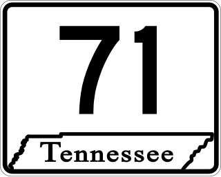
State Route 71 is a north–south state highway in Tennessee. For most of the length it is a "hidden" route, as it coincides with US 441 in all but a short section in Knoxville. The road begins at the North Carolina state line in Sevier County within the Great Smoky Mountains National Park at Newfound Gap and ends at an intersection with US 25W, SR 116, and SR 9 (hidden) in Rocky Top. Along its length SR 71 passes through Sevier County, a small portion of Blount County, Knox County, Anderson County, and in and out of Campbell County. Despite being signed on Hall of Fame Parkway in Knoxville, Tennessee, the Knox County TDOT map ignores SR 71 while SR 33 has a concurrency with US 441.

Interstate 75 (I-75) in the US state of Tennessee runs from Chattanooga to Jellico by way of Knoxville. I-75 enters the East Tennessee region from Georgia, following the Tennessee Valley all the way through Knoxville to near Rocky Top, then climbs into the Cumberland Mountains before crossing over into Kentucky at Jellico.
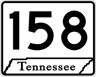
State Route 158 (SR 158) is a major east–west state highway in the city of Knoxville in the U.S. state of Tennessee. It runs 4.63 miles (7.45 km) from Kingston Pike (US 11/US 70) along the Tennessee River to Interstate 40. The western portion of the highway is a surface street known as Neyland Drive and the eastern part is a controlled-access highway called James White Parkway. The entire highway serves as a bypass of downtown Knoxville and as a direct connector to the University of Tennessee (UT) campus and athletic facilities. Serving as the primary means of access to facilities such as Neyland Stadium and Thompson–Boling Arena, the route experiences congestion on game days, with a contraflow lane reversal implemented to mitigate this. It also serves as a spur into downtown and provides access to a number of local landmarks and historic sites, including the Blount Mansion and James White's Fort.
Old North Knoxville is a neighborhood in Knoxville, Tennessee, United States, located just north of the city's downtown area. Initially established as the town of North Knoxville in 1889, the area was a prominent suburb for Knoxville's upper middle and professional classes until the 1950s. After a period of decline, preservationists began restoring many of the neighborhood's houses in the 1980s. In 1992, over 400 houses and secondary structures in the neighborhood were added to the National Register of Historic Places as the Old North Knoxville Historic District.

Bearden, also known as Bearden Village, is a neighborhood in Knoxville, Tennessee, United States, located along Kingston Pike in West Knoxville. Developed primarily as an agrarian community in the 19th century, this neighborhood now lies at the heart of one of Knoxville's major commercial corridors. Named for former Knoxville mayor and Tennessee state legislator, Marcus De Lafayette Bearden (1830–1885), the community was annexed by Knoxville in 1962.
Lake Forest is a neighborhood in Knoxville, Tennessee located in the South Knoxville area. The area covers south of Knoxville Downtown Island Home Airport, then along Island Home Avenue, Chapman Highway, West Red Bud Drive, Stone Road, Oliver Road, Neubert Springs Road, Martin Mill Pike to Ogle Avenue, Doyle Street, Maryville Pike, back to Chapman Highway, then Moody Avenue to Seveirville Pike, East Red Bud Road, and Gilbert Lane.

Lindbergh Forest is a neighborhood in Knoxville, Tennessee, United States, located off Chapman Highway (US-441) in South Knoxville, that is listed on the National Register of Historic Places as an historic district. Initially developed in the late 1920s as one of Knoxville's first automobile suburbs, the neighborhood is now noted for its late-1920s and early-1930s residential architecture, and the use of East Tennessee marble detailing. The neighborhood also contains two of Knoxville's five surviving Lustron houses. In 1998, several of its houses were added to the National Register of Historic Places as the Lindbergh Forest Historic District.

Norwood is a neighborhood in Knoxville, Tennessee. It is located in an area north and west of Interstate 75, north of Interstate 640, east of Western Avenue, and south of Schaad Road and Callahan Drive.
West Hills is a neighborhood in Knoxville, Tennessee, United States, located just off Kingston Pike in West Knoxville. Initially developed in the 1950s, West Hills was Knoxville's first major post-World War II subdivision, and the first subdivision to consist primarily of modern ranch-style houses. While West Knoxville experienced a boom in commercial development in the 1970s and 1980s, West Hills has managed to retain its residential character, due in large part to its aggressive neighborhood advocacy group, the West Hills Community Association.
Cedar Bluff is a neighborhood in Knoxville, Tennessee, United States. It located along Cedar Bluff Road north of I-40 in West Knoxville. The neighborhood lies at the heart of one of Knoxville's major commercial corridors, and is the site of a regional headquarters for Discovery, Inc.

The 2021 Tennessee Volunteers football team represented the University of Tennessee in the 2021 NCAA Division I FBS football season. The Volunteers played their home games at Neyland Stadium in Knoxville, Tennessee, and competed in the Eastern Division of the Southeastern Conference (SEC). They were led by first-year coach Josh Heupel.

