Old North Knoxville

Last updated
Old North Knoxville Historic District
Lou-mar-onk-tn1.jpg
Lou Mar (505 East Scott Avenue), built in 1889
USA Tennessee location map.svg
Red pog.svg
Usa edcp location map.svg
Red pog.svg
LocationRoughly bounded by E. Woodland, Bluff, Armstrong, E. Baxter, and Central Aves.
Knoxville, Tennessee
Coordinates 35°59′13.03″N83°55′18″W / 35.9869528°N 83.92167°W / 35.9869528; -83.92167 Coordinates: 35°59′13.03″N83°55′18″W / 35.9869528°N 83.92167°W / 35.9869528; -83.92167
Area324 acres (131 ha)
Builtc. 18831940 [1]
Architect George Barber, Charles I. Barber, David Getaz, and multiple others
Architectural style Bungalow/Craftsman, Late Victorian, Late-19th and 20th Century Revivals
NRHP reference No. 92000506 [2]
Added to NRHPMay 14, 1992

Old North Knoxville is a neighborhood in Knoxville, Tennessee, United States, located just north of the city's downtown area. Initially established as the town of North Knoxville in 1889, the area was a prominent suburb for Knoxville's upper middle and professional classes until the 1950s. After a period of decline, preservationists began restoring many of the neighborhood's houses in the 1980s. In 1992, over 400 houses and secondary structures in the neighborhood were added to the National Register of Historic Places as the Old North Knoxville Historic District. [1]

Contents

In the years following the Civil War, Knoxville experienced an economic boom that brought about a rapid increase in the city's population. The city gradually expanded northward and westward to accommodate the influx of new residents. The housing boom reached what is now Old North Knoxville in the late 1880s, when it was incorporated as the town of North Knoxville, and continued after its annexation by Knoxville in 1897. The neighborhood's earliest residents included doctors, politicians, and business managers, and some its earliest houses were designed by prominent Knoxville architects, such as George Barber, Charles Barber, and David Getaz. As Knoxville continued expanding northward, most notably with the annexation of Fountain City in 1962, North Knoxville became "Old" North Knoxville. [1]

Location

Circa-1907 "Granitoid," or "singing," pavement along Kenyon Street Kenyon-street-granitoid-onk-tn1.jpg
Circa-1907 "Granitoid," or "singing," pavement along Kenyon Street

Old North Knoxville is located just off Broadway (part of U.S. Route 441), about halfway between downtown Knoxville to the south and Sharp's Ridge to the north. The neighborhood straddles a hill that gradually rises from First Creek and descends toward Second Creek. East Scott Avenue traverses the hill's crest, with the slopes gradually descending southward to East Baxter Avenue and northward to East Woodland Avenue, leaving the houses along East Scott approximately 20 to 40 feet higher than other houses in the neighborhood. [3]

The Old North Knoxville Historic District is roughly bounded by East Woodland Avenue to the northwest, Bluff Street to the northeast, Armstrong Avenue to the east, and Central Avenue to the south. [1] Several other historic districts lie in the vicinity, namely Mechanicsville to the southwest, Fourth and Gill to the south, Park City to the east, and North Hills to the northeast.

History

Detail of an 1886 map showing what is now the Old North Knoxville area North-Knoxville-1886-map-tn1.jpg
Detail of an 1886 map showing what is now the Old North Knoxville area

North Knoxville remained predominantly rural until the latter half of the 19th century. An 1871 map of Knoxville shows scant development along "Broad Street" (Broadway) north of the Knoxville National Cemetery. [4] In the years after the Civil War, however, Knoxville's railroad access and an influx of northern capital helped make Knoxville a major warehousing and textile manufacturing center, bringing about an exponential increase in population. [1] By 1886, several houses and several roads (including Armstrong and "Kennion") had been built in what is now Old North Knoxville, and several factories had been built nearby along Second Creek, namely the Brookside Cotton Mill, the Fantz (Fanz) Sausage Factory, and two marble works. [5]

Rather than wait for annexation by Knoxville in order to obtain city services, North Knoxville incorporated as a separate city on January 16, 1889. L. A. Gratz was elected as the town's first mayor. The new town secured contracts for water and electric lighting deemed superior to the contracts Knoxville had forged, and North Knoxville School was held in high esteem by parents. At the time of its incorporation, North Knoxville was considered one of the best residential neighborhoods in Knoxville, due in part to its relatively small concentration of lower class residents, and by 1895, the town had a population of 3,200. North Knoxville was annexed by Knoxville in 1897. [6]

The Neoclassical-style Dunn Mansion, built in 1905 Dunn-mansion-onk-tn1.jpg
The Neoclassical-style Dunn Mansion, built in 1905

By the early 1900s, trolley tracks connected North Knoxville to downtown Knoxville. The neighborhood consisted primarily of upper middle and professional class residents, including business managers, doctors, lawyers, and professors. One section of Glenwood Avenue was known as "Doctors' Hill," since nearly every home on the block was occupied by a physician. Business leaders living in the neighborhood included Brookside Cotton Mill manager William Lang, H. T. Hackney Company president (and later mayor of Knoxville) Benjamin Morton, and several Southern Railway officials. George Dempster, inventor of the Dempster-Dumpster and a mayor of Knoxville, lived in Old North Knoxville in the 1920s. [1]

North Knoxville continued to grow until the 1940s, by which time most of the original residents had died or moved away. Knoxville's continued expansion northward and westward, as well as the onset of automobile travel, drew the residents of the city's early suburbs further out to newer neighborhoods along the city's periphery. During the 1950s and 1960s, many of the neighborhood's larger houses were converted into low-rent apartments, causing a decline in housing values. The formation of the Old North Knoxville Neighborhood Association in the 1970s, however, led to the restoration and rehabilitation of most of the neighborhood's historic homes. [1]

Old North Knoxville Historic District

House at 518 Glenwood, designed by Knoxville architect Charles Barber 518-glenwood-onk-tn1.jpg
House at 518 Glenwood, designed by Knoxville architect Charles Barber

The Old North Knoxville Historic District covers 324 acres (131 ha), and includes properties along Alexander Street, East Anderson Avenue, Armstrong Avenue, East Baxter Avenue, Cornelia Street, Folsom Avenue, Fremont Place, Glenwood Avenue, Harvey Street, Kenyon Street, Kern Place, Matthews Place, McMillan Street, East Oklahoma Avenue, Rader Place, East Scott Avenue, Shepherd Place, Stewart Place, Thompson Place, and East Woodland Avenue. The district's 496 contributing buildings and structures consist primarily of houses and outbuildings, with one commercial structure. The neighborhood is characterized by short front lawns and large sidewalks. Circa-1907 "Granitoid" pavement, known locally as "singing" pavement due to the sound it makes when cars drive over it, is still found along Kenyon Street. [1]

Houses in Old North Knoxville include designs by three established architects George F. Barber, his son, Charles Barber, and the Swiss-born David Getaz. Architectural styles represented in the district include Queen Anne, Eastlake, Folk Victorian, Bungalow/Craftsman, Dutch Colonial Revival, Tudor Revival, Neoclassical Revival, American Foursquare, and Shingle. The district has one Colonial Revival home (517 East Oklahoma) and one home designed in the French Eclectic style (518 Glenwood). [1]

Notable houses

House at 131 East Oklahoma Avenue, built circa 1910 131-east-oklahoma-avenue-onk-tn1.jpg
House at 131 East Oklahoma Avenue, built circa 1910

See also

Related Research Articles

The Avenues is an affluent neighborhood in Salt Lake City, Utah. It is named after the perfectly gridlike, closely laid out roads called Avenues and Streets. First surveyed in the 1850s, the Avenues became Salt Lake City's first neighborhood. Today, the Avenues neighborhood is generally considered younger, more progressive, and somewhat "artsy" when compared to other neighborhoods. Many young professionals choose to live there due to the culture and easy commute to downtown.. It is also one of the most important strongholds of the Utah Democratic Party.

<span class="mw-page-title-main">Mechanicsville, Knoxville</span> United States historic place

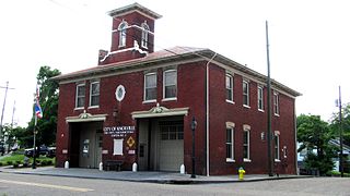
Mechanicsville is a neighborhood in Knoxville, Tennessee, United States, located northwest of the city's downtown area. One of the city's oldest neighborhoods, Mechanicsville was established in the late 1860s for skilled laborers working in the many factories that sprang up along Knoxville's periphery. The neighborhood still contains a significant number of late-19th-century Victorian homes, and a notable concentration of early-20th-century shotgun houses. In 1980, several dozen properties in Mechanicsville were added to the National Register of Historic Places as the Mechanicsville Historic District. The neighborhood was also designated as a local historic district in 1991, subject to historic zoning and design standards.

<span class="mw-page-title-main">Sequoyah Hills</span> Neighborhood of Knoxville, Tennessee, United States

Sequoyah Hills is a neighborhood in Knoxville, Tennessee, United States, named for the Cherokee scholar Sequoyah, inventor of the Cherokee alphabet. It is located off Kingston Pike, between the city's downtown and West Knoxville. Initially developed in the 1920s, Sequoyah Hills was one of Knoxville's first suburbs and today is home to some of the city's most affluent residents. The neighborhood contains numerous notable examples of mid-20th century residential architecture, with houses designed by architects such as Charles I. Barber, Benjamin McMurry, and Francis Keally.

<span class="mw-page-title-main">Neighborhoods of Tulsa, Oklahoma</span>

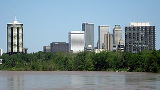
Tulsa is the second-largest city in the state of Oklahoma. It has many diverse neighborhoods due to its size.

<span class="mw-page-title-main">Stuyvesant Square</span> Public park and neighborhood in Manhattan, New York

Stuyvesant Square is the name of both a park and its surrounding neighborhood in the New York City borough of Manhattan. The park is located between 15th Street, 17th Street, Rutherford Place, and Nathan D. Perlman Place. Second Avenue divides the park into two halves, east and west, and each half is surrounded by the original cast-iron fence.

<span class="mw-page-title-main">Old City, Knoxville</span> United States historic place

The Old City is a neighborhood in Knoxville, Tennessee, United States, located at the northeast corner of the city's downtown area. Originally part of a raucous and vice-ridden section of town known as "The Bowery," the Old City has since been revitalized through extensive redevelopment efforts carried out during the 1980s through the present. Currently, the Old City is an offbeat urban neighborhood, home to several unique restaurants, bars, clubs, and shops.

<span class="mw-page-title-main">Knox County Courthouse (Tennessee)</span> United States historic place

The Knox County Courthouse is a historic building located at 300 Main Street in Knoxville, Tennessee, United States. Built in 1886, it served as Knox County's courthouse until the completion of the City-County Building in 1980, and continues to house offices for several county departments. John Sevier, Tennessee's first governor, is buried on the courthouse lawn. The courthouse is listed on the National Register of Historic Places for its architecture and its role in the county's political history.

<span class="mw-page-title-main">Kingston Pike</span> United States historic place

Kingston Pike is a highway in Knox County, Tennessee, United States, that connects Downtown Knoxville with West Knoxville, Farragut, and other communities in the western part of the county. The road follows a merged stretch of U.S. Route 11 (US 11) and US 70. From its initial construction in the 1790s until the development of the Interstate Highway System in the 1960s, Kingston Pike was the main traffic artery in western Knox County, and an important section of several cross-country highways. The road is now a major commercial corridor, containing hundreds of stores, restaurants, and other retail establishments.

<span class="mw-page-title-main">College Hill, Greensboro, North Carolina</span> Historic district in North Carolina, United States

College Hill is a neighborhood in the west central section of the United States city of Greensboro, North Carolina. College Hill was Greensboro's first neighborhood.

<span class="mw-page-title-main">Southern Terminal, Knoxville, Tennessee</span> United States historic place

The Southern Terminal is a former railway complex located at 306 West Depot Avenue in Knoxville, Tennessee, USA. The complex, which includes a passenger terminal and express depot adjacent to a large railyard, was built in 1903 by the Southern Railway. Both the terminal and depot were designed by noted train station architect Frank Pierce Milburn (1868–1926). In 1985, the terminal complex, along with several dozen warehouses and storefronts in the adjacent Old City and vicinity, were listed on the National Register of Historic Places as the Southern Terminal and Warehouse Historic District.

<span class="mw-page-title-main">Market Square, Knoxville</span> United States historic place

Market Square is a historic district and pedestrian mall located in downtown Knoxville, Tennessee, United States. Established in 1854 as a market place for regional farmers, the square has developed over the decades into a multipurpose venue that accommodates events ranging from concerts to political rallies, and has long provided a popular gathering place for artists, street musicians, war veterans, and activists. Along with the Market House, Market Square was home to Knoxville's City Hall from 1868 to 1924. Market Square was listed on the National Register of Historic Places in 1984.

<span class="mw-page-title-main">Fort Sanders, Knoxville</span> United States historic place

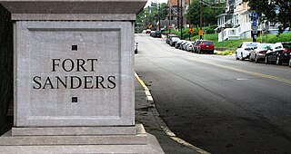
Fort Sanders is a neighborhood in Knoxville, Tennessee, USA, located west of the downtown area and immediately north of the main campus of the University of Tennessee. Developed in the late 19th century as a residential area for Knoxville's growing upper and middle classes, the neighborhood now provides housing primarily for the university's student population. The neighborhood still contains a notable number of its original Victorian-era houses and other buildings, several hundred of which were added to the National Register of Historic Places in 1980 as the Fort Sanders Historic District.

<span class="mw-page-title-main">Fourth and Gill, Knoxville</span> Historic house in Tennessee, United States

Fourth and Gill is a neighborhood in Knoxville, Tennessee, United States, located north of the city's downtown area. Initially developed in the late nineteenth century as a residential area for Knoxville's growing middle and professional classes, the neighborhood still contains most of its original Victorian-era houses, churches, and streetscapes. In 1985, 282 houses and other buildings in the neighborhood were added to the National Register of Historic Places as the Fourth and Gill Historic District.

<span class="mw-page-title-main">Island Home Park, Knoxville</span> United States historic place

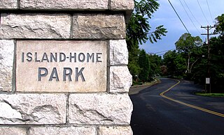
Island Home Park is a neighborhood in Knoxville, Tennessee, United States, located in the southeastern part of the city along the Tennessee River. Developed as a streetcar suburb in the early 1900s, the neighborhood retains most of its original houses and streetscapes, and is home to the city's largest concentration of Bungalow-style houses. In 1994, several dozen houses in Island Home Park were added to the National Register of Historic Places as the Island Home Park Historic District.

<span class="mw-page-title-main">Lindbergh Forest</span> Historic house in Tennessee, United States

Lindbergh Forest is a neighborhood in Knoxville, Tennessee, United States, located off Chapman Highway (US-441) in South Knoxville, that is listed on the National Register of Historic Places as an historic district. Initially developed in the late 1920s as one of Knoxville's first automobile suburbs, the neighborhood is now noted for its late-1920s and early-1930s residential architecture, and the use of East Tennessee marble detailing. The neighborhood also contains two of Knoxville's five surviving Lustron houses. In 1998, several of its houses were added to the National Register of Historic Places as the Lindbergh Forest Historic District.

<span class="mw-page-title-main">Parkridge, Knoxville</span> United States historic place

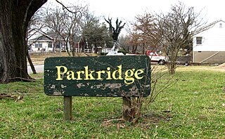
Parkridge is a neighborhood in Knoxville, Tennessee, United States, located off Magnolia Avenue east of the city's downtown area. Developed as a streetcar suburb for Knoxville's professional class in the 1890s, the neighborhood was incorporated as the separate city of Park City in 1907, and annexed by Knoxville in 1917. In the early 1900s, the neighborhood provided housing for workers at the nearby Standard Knitting Mill factory.

<span class="mw-page-title-main">Emory Place Historic District</span> Historic district in Tennessee, United States

The Emory Place Historic District is a historic district in Knoxville, Tennessee, United States, located just north of the city's downtown area. The district consists of several commercial, residential, religious, and public buildings that developed around a late nineteenth century train and trolley station. The district includes the Knoxville High School building, St. John's Lutheran Church, First Christian Church, and some of the few surviving rowhouses in Knoxville. The district was listed on the National Register of Historic Places in 1994.

Portland, Maine, is home to many neighborhoods.

<span class="mw-page-title-main">South Market Historic District</span> Historic district in Tennessee, United States

The South Market Historic District is a cluster of five buildings at the intersection of Market Street and Church Avenue in Knoxville, Tennessee, United States, listed on the National Register of Historic Places in 1996. The buildings, which include the Cherokee Building, the Ely Building, the Cunningham, the Stuart, and the Cate, were built circa 1895—1907, and were used for both office space and residential space. Several prominent Knoxville physicians and three marble companies operated out of the buildings in this district in the early 1900s.

References

  1. 1 2 3 4 5 6 7 8 9 10 11 12 13 14 15 16 17 18 Ann Bennett, National Register of Historic Places Nomination Form for Old North Knoxville Historic District, 9 August 1991.
  2. "National Register Information System". National Register of Historic Places . National Park Service. March 13, 2009.
  3. USGS topographical map, "Knoxville, TN," 1:24. Accessed via Topoquest.com, 4 June 2010.
  4. A. Ruger, Bird's Eye View of the City of Knoxville, Knox County, Tennessee. Merchants Lith Co., 1871. Retrieved from Library of Congress online database, 4 June 2010.
  5. H. Wellge, Knoxville, Tenn., County Seat of Knox County. Norris, Wellge & Co., 1886. Retrieved from Library of Congress online database, 4 June 2010.
  6. A Brief History of Old North Knoxville Archived 2013-08-10 at the Wayback Machine , 2009. Retrieved: 4 June 2010.
  7. Ann Bennett, Historic and Architectural Resources of Knoxville and Knox County, Tennessee, May 1994, p. 26.
  8. Old House Journal, , Sept-Oct 2009, cover and pp. 44-49.