France–UK border

Last updated
France-UK border
Characteristics
EntitiesFlag of France.svg  France Flag of the United Kingdom.svg  United Kingdom
History
Established1903
Current shape1986
TreatiesInternational arbitrations from 1977, 1978, 1982, 1988 and 1991 for the maritime border and the Treaty of Canterbury (1986) for the channel tunnel.

The border between the countries of France and the United Kingdom in Europe is a maritime border that stretches along the Channel, the North Sea and the Atlantic Ocean. The Channel Tunnel links the two countries underground and is defined as a 'land frontier', and not widely recognised as a land border.

Contents

Geological profile along the tunnel (in brown) as constructed above sea Channel Tunnel geological profile 1.svg
Geological profile along the tunnel (in brown) as constructed above sea

It is defined by several international arbitrations from 1977, 1978, 1982, 1988 and 1991 [1] for the maritime border and by the Treaty of Canterbury (1986) for the channel tunnel.

Maritime border

Maritime boundaries between UK and France in Europe-fr.svg
  1. 50°07′29″N00°30′00″W / 50.12472°N 0.50000°W / 50.12472; -0.50000 (point A)
  2. 50°08′27″N01°00′00″W / 50.14083°N 1.00000°W / 50.14083; -1.00000 (point B)
  3. 50°09′15″N01°30′00″W / 50.15417°N 1.50000°W / 50.15417; -1.50000 (point C)
  4. 50°09′14″N02°03′26″W / 50.15389°N 2.05722°W / 50.15389; -2.05722 (point D)
  5. 49°57′50″N02°48′24″W / 49.96389°N 2.80667°W / 49.96389; -2.80667 (point D1)
  6. 49°46′30″N02°56′30″W / 49.77500°N 2.94167°W / 49.77500; -2.94167 (point D2)
  7. 49°38′30″N03°21′00″W / 49.64167°N 3.35000°W / 49.64167; -3.35000 (point D3)
  8. 49°33′12″N03°34′50″W / 49.55333°N 3.58056°W / 49.55333; -3.58056 (point D4)
  9. 49°32′42″N03°42′44″W / 49.54500°N 3.71222°W / 49.54500; -3.71222 (point E)
  10. 49°32′08″N03°55′47″W / 49.53556°N 3.92972°W / 49.53556; -3.92972 (point F)
  11. 49°27′40″N04°17′54″W / 49.46111°N 4.29833°W / 49.46111; -4.29833 (point F1)
  12. 49°27′23″N04°21′46″W / 49.45639°N 4.36278°W / 49.45639; -4.36278 (point G)
  13. 49°23′14″N04°32′39″W / 49.38722°N 4.54417°W / 49.38722; -4.54417 (point H)
  14. 49°14′28″N05°11′00″W / 49.24111°N 5.18333°W / 49.24111; -5.18333 (point I)
  15. 49°13′22″N05°18′00″W / 49.22278°N 5.30000°W / 49.22278; -5.30000 (point J)
  16. 49°13′00″N05°20′40″W / 49.21667°N 5.34444°W / 49.21667; -5.34444 (point K)
  17. 49°12′10″N05°40′30″W / 49.20278°N 5.67500°W / 49.20278; -5.67500 (point L)
  18. 49°12′00″N05°41′30″W / 49.20000°N 5.69167°W / 49.20000; -5.69167 (point M)
  19. 48°06′00″N09°36′30″W / 48.10000°N 9.60833°W / 48.10000; -9.60833 (point N)

In 2003, France signed an agreement with the United Kingdom to introduce 'juxtaposed controls' (in French, des bureaux de contrôles nationaux juxtaposés, or 'BCNJ') at Dover on the British side and at Calais, Dunkerque and Boulogne-sur-Mer on the French side.

This means that, when travelling from Dover to France by ferry, French immigration checks are carried out by the Police aux Frontières on British soil before boarding the ferry, whilst French customs checks take place upon arrival on French soil.

The Port of Calais Zone portuaire calais phare.jpg
The Port of Calais

When travelling in the reverse direction from Calais, Dunkerque and Boulogne-sur-Mer in France to the UK by ferry, French immigration exit checks and British immigration checks both take place on French soil before boarding the ferry, whilst British customs checks take place upon arrival on British soil.

Border crossing pointFrench agency responsible for checksNature of presenceFerries to/from outside the Schengen Area
ImmigrationCustomsCompanyForeign port(s)
Caen portPolice aux FrontièresCustomsPermanent Brittany Ferries Portsmouth
Calais portPolice aux FrontièresCustomsPermanent DFDS Seaways and P&O Ferries Dover
Carteret portPolice aux FrontièresCustomsPermanentManche Îles Express Guernsey and Jersey
Cherbourg portPolice aux FrontièresCustomsPermanent Brittany Ferries
Irish Ferries
Poole and Portsmouth
Rosslare
Diélette portCustomsCustomsPermanentManche Îles Express Alderney and Guernsey
Dieppe portPolice aux FrontièresCustomsPermanent DFDS Seaways Newhaven
Dunkerque portPolice aux FrontièresCustomsPermanent DFDS Seaways Dover
Granville portPolice aux FrontièresCustomsPermanentManche Îles Express Jersey
Le Havre portPolice aux FrontièresCustomsPermanent LD Lines Portsmouth
Marseille portPolice aux FrontièresCustomsPermanent Algérie Ferries Algiers, Bejaia, Oran and Skikda
Roscoff portCustomsCustomsPermanent Brittany Ferries
Irish Ferries
Cork and Plymouth
Rosslare
Saint Malo portPolice aux FrontièresCustomsPermanent Brittany Ferries
Condor Ferries
Portsmouth
Guernsey, Jersey, Poole, Weymouth
Sète portPolice aux FrontièresCustomsPermanent Comarit Nador and Tangier

Land frontier

General Wolseley riding on the fleeing lion. Published in the American humour magazine Puck (approx. 1885). It depicts fears of a Channel Tunnel LionCannotFaceTheCrowingOfCock.png
General Wolseley riding on the fleeing lion. Published in the American humour magazine Puck (approx. 1885). It depicts fears of a Channel Tunnel
Channel Tunnel course Course Channeltunnel en.svg
Channel Tunnel course
Channel Tunnel / Eurotunnel
BSicon CONTg.svg
BSicon dPORTALf.svg
BSicon dCONTg.svg
BSicon dSTRc2.svg
BSicon dABZg3.svg
BSicon vSTR+1-.svg
BSicon tvSHI2l-.svg
BSicon STRc4.svg
BSicon vSHI2gl-.svg
BSicon dSTR.svg
BSicon tdSTRe@f.svg
BSicon dBUE.svg
BSicon vSTR-.svg
Dollands Moor Level Crossing
BSicon v-STR.svg
BSicon GRZ.svg
BSicon vUSTl.svg
BSicon dSTR.svg
BSicon lELC.svg
DC┇AC changeover
BSicon vSTR.svg
BSicon dDST.svg
BSicon vSTR-.svg
BSicon dNULg.svg
BSicon dSTR.svg
BSicon vSTR.svg
BSicon dBRUCKE1.svg
Balancing Ponds Viaduct (
120 m
131 yd
)
BSicon dBRUCKE1.svg
BSicon vSTR.svg
BSicon dNULf.svg
BSicon dSTR.svg
Grange Alders Viaduct (
526 m
575 yd
)
BSicon POINTERf@rgq.svg
BSicon v-STR2.svg
BSicon v-SHI2g+r.svg
BSicon UWu3.svg
BSicon GRZ.svg
BSicon vSTR3-.svg
BSicon dSTR.svg
Dover Line Viaduct (
116 m
127 yd
)
BSicon UWu1.svg
BSicon CONT3+1.svg
BSicon v-STR.svg
BSicon v-SHI2+l.svg
BSicon v-STR+4.svg
BSicon dSHI2r.svg
BSicon RBe.svg
BSicon SKRZ-Bo.svg
BSicon RBw.svg
M20 motorway Viaduct (
309 m
338 yd
)
BSicon STR+GRZq.svg
-1.659 km
-1.031 mi
BSicon t3STR+1.svg
BSicon STR.svg
BSicon t3STRq-.svg
BSicon t3STR+4.svg
Cheriton Cut-and-Cover Tunnel (
1010 m
1105 yd
)
BSicon dPORTALg.svg
BSicon vSHI2gl-.svg
BSicon dSTR.svg
BSicon dPORTALg.svg
BSicon dINT.svg
Folkestone Shuttle Terminal Eurotunnel.svg BSicon CARSHUTTLE.svg
-4.436 km
-2.756 mi
BSicon dNULg.svg
BSicon dSTR2.svg
BSicon STRc3.svg
BSicon dDST.svg
BSicon dSTR.svg
BSicon dSTRc2.svg
BSicon dNULf.svg
BSicon dSTR3.svg
Folkestone Shuttle Sidings
BSicon dSHI1c1.svg
BSicon cSTRc1.svg
BSicon dSTR2h+4.svg
BSicon SPLa.svg
BSicon dSHI1+r.svg
BSicon dSTR3h+1.svg
BSicon cSTRc4.svg
Cheriton Junction
BSicon RP1+r.svg
BSicon vSTRgf.svg
Service Road
BSicon PORTALf.svg
BSicon RP1yRD1.svg
BSicon tvSTRa.svg
Castle Hill Tunnel Portal
0 km
0 mi
BSicon RD1.svg
BSicon tvUSTr.svg
UK Crossovers
0.478 km
0.297 mi
BSicon RD1.svg
BSicon tvUSTl.svg
Holywell Cut-and-Cover Tunnel
0.882 km
0.548 mi
BSicon RD1Kl.svg
BSicon tvSTR.svg
BSicon RD1K+r.svg
BSicon exlGRZq.svg
BSicon tvSTR.svg
BSicon exlGRZeq.svg
BSicon exlBHF grey.svg
BSicon RD1.svg
Shakespeare Cliff Shaft
(Adits A1 & A2)
BSicon tvSTRgf.svg
BSicon RD1.svg
BSicon tvSTR.svg
BSicon RD1Kl.svg
BSicon RD1K+r.svg
BSicon tvUST.svg
BSicon RD1.svg
UK Undersea Crossover
17.062 km
10.602 mi
BSicon tvSTR.svg
BSicon RD1K+l.svg
BSicon RD1Kr.svg
BSicon GRZq.svg
BSicon RD1.svg
BSicon tvGRENZE.svg
BSicon vNULgf.svg
BSicon GRZq.svg
BSicon GRZq.svg
United Kingdom
France
26.988 km
16.77 mi
BSicon tvSTR.svg
BSicon RD1Kl.svg
BSicon RD1K+r.svg
BSicon tvUST.svg
BSicon RD1.svg
French Undersea Crossover
34.688 km
21.554 mi
BSicon tvSTR.svg
BSicon RD1K+l.svg
BSicon RD1Kr.svg
BSicon tvSTRgf.svg
BSicon RD1.svg
BSicon tvSTR.svg
BSicon exlBHF grey.svg
BSicon RD1.svg
Sangatte Shaft
BSicon RD1Kl.svg
BSicon tvSTR.svg
BSicon RD1K+r.svg
BSicon lcCSTR+L.svg
BSicon tvSTRe@g.svg
BSicon PORTALg.svg
BSicon lCSTR(l).svg
BSicon RD1yRP1.svg
Beussingues Tunnel Portal
50.459 km
31.354 mi
BSicon lcCSTR+L.svg
BSicon vSTRgf.svg
BSicon lCSTR(l).svg
BSicon RP1.svg
Beussingues Trench
BSicon lcCSTRe+L.svg
BSicon vUST.svg
BSicon lCSTRe(l).svg
BSicon RP1.svg
French Crossover
BSicon vUSTl.svg
BSicon RP1l.svg
Service Road
BSicon MASKl.svg
BSicon RRq.svg
BSicon RRq.svg
BSicon vSKRZ-G4u.svg
BSicon MASKr.svg
BSicon RRq.svg
BSicon lCONTg@Gq.svg
BSicon v-STR+r.svg
BSicon STR2+r.svg
BSicon STRc3.svg
BSicon dSHI2l.svg
BSicon d-KRZ2+4o.svg
BSicon STRc3.svg
BSicon STRc1.svg
BSicon v-STR.svg
BSicon v-STR4.svg
BSicon GRZ.svg
BSicon dSHI2+l.svg
BSicon dKRZc1o.svg
BSicon dSHI2lr.svg
BSicon dSHI2+r.svg
BSicon SPL+4.svg
BSicon v-STR.svg
BSicon GRZ.svg
BSicon vDST-STR.svg
BSicon vSTR.svg
Fréthun Freight Yard
BSicon STRc2.svg
BSicon v-STR.svg
BSicon v-STR.svg
BSicon GRZ.svg
BSicon v-NULf.svg
BSicon SPLg+3.svg
BSicon vDST-STR.svg
Coquelles Eurotunnel Depot
BSicon CONT3+1.svg
BSicon v-STR3.svg
BSicon dSTRc4.svg
BSicon dSHI2g+l.svg
BSicon dSHI2r.svg
BSicon dSTRg.svg
BSicon STRl.svg
BSicon lINT.svg
BSicon STRr.svg
Calais Shuttle Terminal Eurotunnel.svg BSicon CARSHUTTLE.svg
57.795 km
35.912 mi
Distances from Castle Hill Tunnel Portal
Distances to terminals measured around terminal loops

The Treaty of Canterbury (French : Traité de Cantorbéry) was signed by British Prime Minister Margaret Thatcher and Foreign Secretary Sir Geoffrey Howe, French President François Mitterrand and Minister of Foreign Affairs Roland Dumas on 12 February 1986, and is the original document providing for the undersea tunnel between the two countries. [2]

The Treaty of Canterbury (1986) is significant and unusual because it is a modern and recent modification to the national borders of the UK and France.

The Anglo-French Treaty on the Channel Tunnel was signed by both governments in Canterbury Cathedral. The treaty prepared the concession for the construction and operation of the fixed link by privately owned companies. It outlines the methods to be used for arbitration in the event of a dispute. It sets up the Intergovernmental Commission (IGC) which is responsible for monitoring all matters associated with the construction and operation of the tunnel on behalf of the British and French governments, together with a Safety Authority to advise the IGC.

It draws a land frontier between the two countries in the middle of the Channel tunnel – the first of its kind. [3] [4] [5]

In the 1991 Sangatte Protocol, France signed an agreement with the United Kingdom to introduce 'juxtaposed controls' (in French, des bureaux de contrôles nationaux juxtaposés, or 'BCNJ') at Eurostar and Eurotunnel stations on immigration and customs, where investigations happen before travel. France is part of the Schengen Agreement, which has largely abolished border checks between member nations, but the United Kingdom is not.

These juxtaposed controls mean that passports are checked before boarding first by officials belonging to departing country and then officials of the destination country. These are placed only at the main Eurostar stations: French officials operate at London St Pancras, Ebbsfleet International and Ashford International, while British officials operate at Calais-Fréthun, Lille-Europe, Marne-la-Vallée–Chessy and Paris-Gare du Nord. There are security checks before boarding as well. For the shuttle road-vehicle trains, there are juxtaposed passport controls before boarding the trains.

Border crossing pointFrench agency responsible for checksNature of presenceTrains to/from outside the Schengen Area
ImmigrationCustoms
Bourg-Saint-Maurice railway station CustomsCustomsSeasonal
(beginning of December to mid-April)
Seasonal Eurostar ski service
Calais Fréthun railway station Police aux FrontièresCustomsPermanentUp to three Eurostar trains per day to/from London St Pancras, Trains no longer call at intermediate stations Ashford International and Ebbsfleet International.CustomsPermanentFrequent Eurotunnel Shuttle services to/from Cheriton, Kent.
Lille Europe railway station Police aux FrontièresCustomsPermanentUp to ten Eurostar trains per day to/from London St Pancras, Trains no longer call at Ashford International and Ebbsfleet International.
Marne-la-Vallée – Chessy railway station Police aux FrontièresCustomsPermanentUp to one Eurostar train per day to/from London St Pancras.
Moûtiers–Salins–Brides-les-Bains railway stationCustomsCustomsSeasonal
(beginning of December to mid-April)
Seasonal Eurostar ski service
Paris Gare du Nord railway station Police aux FrontièresCustomsPermanentUp to 16 Eurostar trains per day to/from London St Pancras, Trains no longer call at intermediate stations Ashford International and Ebbsfleet International.

Bibliography

See also

Related Research Articles

<span class="mw-page-title-main">Channel Tunnel</span> Undersea rail tunnel linking France and England

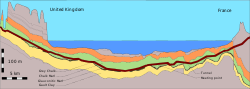
The Channel Tunnel, also known as the Chunnel, is a 50.46-kilometre (31.35 mi) underwater railway tunnel that connects Folkestone with Coquelles beneath the English Channel at the Strait of Dover. It is the only fixed link between the island of Great Britain and the European mainland. At its lowest point, it is 75 metres (246 ft) deep below the sea bed and 115 metres (377 ft) below sea level. At 37.9 kilometres (23.5 mi), it has the longest underwater section of any tunnel in the world, and is the third longest railway tunnel in the world. The speed limit for trains through the tunnel is 160 kilometres per hour (99 mph). The tunnel is owned and operated by the company Getlink, formerly "Groupe Eurotunnel".

The 49th parallel north is a circle of latitude that is 49° north of Earth's equator. It crosses Europe, Asia, the Pacific Ocean, North America, and the Atlantic Ocean.

<span class="mw-page-title-main">LGV Nord</span> French high-speed railway

The Ligne à Grande Vitesse Nord, typically shortened to LGV Nord, is a French 333-kilometre (207 mi)-long high-speed rail line, opened in 1993, that connects Paris to the Belgian border and the Channel Tunnel via Lille.

<span class="mw-page-title-main">Sangatte</span> Commune in Hauts-de-France, France

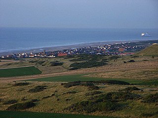
Sangatte is a commune in the Pas-de-Calais department on the northern coast of France on the English Channel. The name is of Flemish origin, meaning hole or gap in the sand.

<span class="mw-page-title-main">Eurotunnel Shuttle</span> Car shuttle train service between England and France

Eurotunnel Le Shuttle is a railway shuttle service between Coquelles in Pas-de-Calais, France and Cheriton in Kent, United Kingdom. It conveys road vehicles and passengers by rail through the Channel Tunnel. Freight vehicles are carried in separate shuttle trains hauled by the same locomotives, that also contain a passenger carriage, known as the Club Car.

<span class="mw-page-title-main">Geography of England</span> Geographical features of England

England comprises most of the central and southern two-thirds of the island of Great Britain, in addition to a number of small islands of which the largest is the Isle of Wight. England is bordered to the north by Scotland and to the west by Wales. It is closer to continental Europe than any other part of mainland Britain, divided from France only by a 33 km (21 mi) sea gap, the English Channel. The 50 km (31 mi) Channel Tunnel, near Folkestone, directly links England to mainland Europe. The English/French border is halfway along the tunnel.

<span class="mw-page-title-main">Calais-Fréthun station</span> Railway station in Calais, France

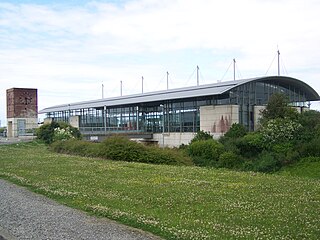
Calais-Fréthun station is an SNCF international railway station in the suburbs of Calais, France. It is one of four stations serving the town; the others are Calais-Ville in the town centre, Fontinettes in the suburbs, and Beau Marais in the suburbs.

<span class="mw-page-title-main">Lille-Europe station</span>

Lille-Europe station is a SNCF railway station in Lille, France, on the LGV Nord high-speed railway. The station is primarily used for international Eurostar and long-distance SNCF TGV services, although some high-speed regional trains also call at the station. The station was built in 1993 to be used as a through station for trains between the UK, Belgium, and the Netherlands, as well as French TGV services, except those coming from Paris which normally terminate at Lille-Flandres. There is a 400 m (1,300 ft) walking distance between the two stations, which are also adjacent stops on the Lille Metro.

<span class="mw-page-title-main">Pale of Calais</span> Region of northern France controlled by England during the middle ages

The Pale of Calais was a territory in Northern France ruled by the monarchs of England for more than two hundred years from 1347 to 1558. The area, which was taken following the Battle of Crécy in 1346 and the subsequent siege of Calais, was confirmed at the Treaty of Brétigny in 1360. It became an important economic centre for England in Europe’s textile trade centred in Flanders.

<span class="mw-page-title-main">Channel Tunnel Act 1987</span> United Kingdom legislation

The Channel Tunnel Act 1987(c. 53) is an Act of the Parliament of the United Kingdom which authorised the construction of the Channel Tunnel between the United Kingdom and France in accordance with the Treaty of Canterbury, which was signed in 1986. Section 2 of the Act forbade any public subsidy of the project.

<span class="mw-page-title-main">Siege of Calais (1558)</span> 1558 battle between England and France

The French siege of Calais in early 1558 was part of the Italian War of 1551–1559 between France and England and their respective allies. It resulted in the seizure of the town by France.

<span class="mw-page-title-main">Eurotunnel Folkestone Terminal</span>

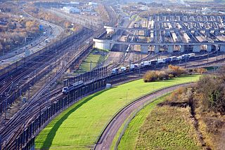
The Eurotunnel Folkestone Terminal is a railway terminal built for the transport of road-going vehicles on specially constructed trains through the Channel Tunnel. The terminal is one of two, with the Eurotunnel Calais Terminal located at Coquelles, near Calais.

<span class="mw-page-title-main">Eurotunnel Calais Terminal</span> Train station served by Eurotunnel trains to the UK via the Channel Tunnel

The Eurotunnel Calais Terminal is a railway terminal built for the transport of road-going vehicles on specially constructed trains through the Channel Tunnel. The terminal is one of two, with the Eurotunnel Folkestone Terminal located at Cheriton, near Folkestone.

<span class="mw-page-title-main">Juxtaposed controls</span>

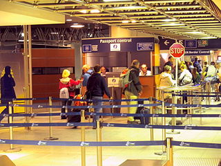
Juxtaposed controls are a reciprocal arrangement between Belgium, France, the Netherlands and the United Kingdom whereby border controls on certain cross-Channel routes take place before boarding the train or ferry, rather than upon arrival after disembarkation. With the exception of the Eurotunnel Shuttle route, customs checks remain unaffected by juxtaposed immigration controls and continue to take place upon arrival after disembarkation. Belgium, France and the Netherlands are all member states of the European Union and part of the border-free Schengen Area. The United Kingdom, on the other hand, has never participated in the Schengen Area, even when it was a member state of the European Union. As a result, juxtaposed controls aim to increase the convenience and efficiency of border checks when travelling by train or ferry between the Schengen Area and the UK by removing the need for immigration checks on arrival and by streamlining checks on departure. At the same time, juxtaposed controls are intended to detect and prevent illegal immigration. In 2016, there were over 56,000 instances when people were refused entry to the UK at the juxtaposed controls.

HMS Cooke (K471) was a British Captain-class frigate of the Royal Navy in commission during World War II. Originally constructed as the United States Navy Evarts-class destroyer escort USS Dempsey (DE-267), she served in the Royal Navy from 1943 to 1946.

<span class="mw-page-title-main">Migrants around Calais</span>

Migrants have gathered in and around Calais, on the northern French coast, since at least the late 1990s seeking to enter the United Kingdom from the French port by crossing the Channel Tunnel or stowing away in the cargo area of lorries heading for ferries that cross the English Channel. During this time, informal camps of migrants have formed, the most notorious commonly referred to as the Calais Jungle. Other migrants come to the area because they are homeless while seeking asylum in France. The presence of migrants in and around Calais has affected the British and French governments, the Eurotunnel and P&O Ferries companies, and lorry drivers heading for the UK and their companies. EuroTunnel, the company that operates the Channel Tunnel, said that it intercepted more than 37,000 migrants between January and July 2015.

<span class="mw-page-title-main">Port of Calais</span> Port in France

The Port of Calais in northern France is the fourth largest port in France and the largest for passenger traffic. It accounts for more than a third of economic activity in the town of Calais.

The Calais border barrier is an international border barrier under construction jointly by France and the United Kingdom designed to prevent illegal migrants from gaining access to the Channel Tunnel and from the port of Calais as a means of illegal entry to Britain. Construction, funded by Britain, began in September 2016.

References

  1. United Nations (ed.). "Delimitation of the Continental Shelf between the United Kingdom of Great Britain and Northern Ireland and the French Republic" (PDF).
  2. The New York Times: British-French Tunnel Treaty
  3. Eurotunnel 2005 Annual Review, accessed on 10 December 2007 "Archived copy" (PDF). Archived from the original (PDF) on 30 May 2008. Retrieved 10 December 2007.{{cite web}}: CS1 maint: archived copy as title (link)
  4. BBC Inside Out - South East: Monday 14 October 2002, accessed on 11 December 2007 http://www.bbc.co.uk/insideout/southeast/series1/channel-tunnel.shtml
  5. United Nations (ed.). "Treaty concerning the construction and operation by private concessionaires of a channel fixed link. Signed at Canterbury on 12 February 1986" (PDF).