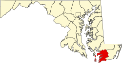
Frenchtown-Rumbly, Maryland | |
---|---|
Coordinates: 38°4′57″N75°51′46″W / 38.08250°N 75.86278°W | |
Country | United States |
State | Maryland |
County | Somerset |
Area | |
• Total | 8.39 sq mi (21.74 km2) |
• Land | 3.76 sq mi (9.73 km2) |
• Water | 4.63 sq mi (12.01 km2) |
Population (2020) | |
• Total | 86 |
• Density | 22.88/sq mi (8.84/km2) |
Time zone | UTC−5 (Eastern (EST)) |
• Summer (DST) | UTC−4 (EDT) |
ZIP code | 21871 [2] |
Area code(s) | 410 and 443 and 667 |
FIPS code | 24-30567 |
Frenchtown-Rumbly is a census-designated place in Somerset County, Maryland, United States. The population was 96 at the 2000 census. It is included in the Salisbury, Maryland-Delaware Metropolitan Statistical Area.
Frenchtown-Rumbly is located at 38°4′57″N75°51′46″W / 38.08250°N 75.86278°W (38.082475, −75.862791). [3]
According to the United States Census Bureau, the CDP has a total area of 8.4 square miles (22 km2), of which 4.2 square miles (11 km2) is land and 4.2 square miles (11 km2) (50.36%) is water.
Census | Pop. | Note | %± |
---|---|---|---|
2020 | 86 | — | |
U.S. Decennial Census [4] |
As of the census [5] of 2000, there were 96 people, 47 households, and 29 families residing in the CDP. The population density was 23.1 inhabitants per square mile (8.9/km2). There were 97 housing units at an average density of 23.4 per square mile (9.0/km2). The racial makeup of the CDP was 95.83% White and 4.17% African American.
There were 47 households, out of which 19.1% had children under the age of 18 living with them, 53.2% were married couples living together, 8.5% had a female householder with no husband present, and 36.2% were non-families. 31.9% of all households were made up of individuals, and 12.8% had someone living alone who was 65 years of age or older. The average household size was 2.04 and the average family size was 2.57.
In the CDP, the population was spread out, with 19.8% under the age of 18, 26.0% from 25 to 44, 32.3% from 45 to 64, and 21.9% who were 65 years of age or older. The median age was 48 years. For every 100 females, there were 104.3 males. For every 100 females age 18 and over, there were 97.4 males.
The median income for a household in the CDP was $28,542, and the median income for a family was $28,750. Males had a median income of $16,250 versus $0 for females. The per capita income for the CDP was $15,430. There were no families and 14.3% of the population living below the poverty line, including no under eighteens and none of those over 64.
Chance is a census-designated place (CDP) in Somerset County, Maryland, United States. The population was 377 at the 2000 census. It is included in the Salisbury, Maryland-Delaware Metropolitan Statistical Area.
Dames Quarter is a census-designated place (CDP) in Somerset County, Maryland, United States. The population was 188 at the 2000 census. It is included in the Salisbury, Maryland-Delaware Metropolitan Statistical Area.
Fairmount is a census-designated place (CDP) in Somerset County, Maryland, United States. The population was 537 at the 2000 census. It is included in the Salisbury, Maryland-Delaware Metropolitan Statistical Area.
Mount Vernon is a census-designated place (CDP) in Somerset County, Maryland, United States. The population was 761 at the 2000 census. It is included in the Salisbury, Maryland-Delaware Metropolitan Statistical Area.
West Pocomoke is a census-designated place (CDP) in Somerset County, Maryland, United States. The population was 498 at the 2000 census. It is included in the Salisbury, Maryland-Delaware Metropolitan Statistical Area.
Girdletree is a census-designated place in Worcester County, Maryland, United States. The population was 149 at the 2010 census. It is part of the Salisbury, Maryland-Delaware Metropolitan Statistical Area.
West Ocean City is a census-designated place (CDP) in Worcester County, Maryland, United States. The population was 4,375 at the 2010 census. It is part of the Salisbury, Maryland-Delaware Metropolitan Statistical Area.
Whaleyville is a census-designated place in Worcester County, Maryland, United States. The population was 149 at the 2010 census. It is part of the Salisbury, Maryland-Delaware Metropolitan Statistical Area.
Detroit Beach is an unincorporated community and census-designated place (CDP) in Monroe County in the U.S. state of Michigan. The population was 1,957 at the 2020 census. The CDP is located within Frenchtown Charter Township, and as an unincorporated community, Detroit Beach has no legal autonomy of its own.
Woodland Beach is a census-designated place (CDP) and unincorporated community in Monroe County in the U.S. state of Michigan. The population was 1,899 at the 2020 census. The CDP is located within Frenchtown Charter Township.
Frenchtown is a census-designated place (CDP) in Missoula County, Montana, United States. It is part of the 'Missoula, Montana Metropolitan Statistical Area'. The population was 1,825 at the 2010 census, an increase from its population of 883 in 2000. Frenchtown is also known as an early mixed ancestry settlement in the Pacific Northwest history, sometimes referred as a French Canadian or a Métis settlement.
West Canton is an unincorporated community and census-designated place (CDP) in Haywood County, North Carolina, United States. The population was 1,247 at the 2010 census. It is part of the Asheville Metropolitan Statistical Area.
Flying Hills is a census-designated place (CDP) in Cumru Township, Berks County, Pennsylvania. The population was 2,568 as of the 2010 census.
Spring Ridge is a census-designated place (CDP) in Spring Township, Berks County, Pennsylvania, United States. The population was 1,003 at the 2010 census.
Kenilworth is a census-designated place (CDP) in North Coventry Township, Chester County, Pennsylvania, United States. The population was 2,148 at the 2020 census.
South Pottstown is a community in North Coventry Township, Chester County in the U.S. state of Pennsylvania. It is defined by the U.S. Census Bureau as a census-designated place (CDP) for statistical purposes and does not have any legal status as a separately incorporated municipality. It is a part of the Pottstown urban area. The population was 2,081 at the 2010 census.
Arlington Heights is a census-designated place (CDP) in Monroe County, Pennsylvania, United States. The population was 6,331 at the 2020 census. One notable location in Arlington Heights is the Stroud Mall.
Edgewater-Paisano is a suburb of Mathis, Texas and a census-designated place (CDP) in San Patricio County, Texas, United States. The population was 182 at the 2000 census.
Yorkshire is a census-designated place (CDP) in Prince William County, Virginia, United States. It is an annex of Manassas, Virginia. The population was 6,732 at the 2000 census.
Brookhurst is a census-designated place (CDP) in Natrona County, Wyoming, United States. It is part of the Casper, Wyoming Metropolitan Statistical Area. The population was 185 at the 2010 census.