Funamanu

Last updated

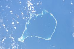
Funamanu is a small narrow island that is part of Funafuti atoll in Tuvalu. It is a motu (islet) or very small island and is located 2.6 miles southwestward of the southwest tip of Funafuti. The islet is known to be covered in coconut trees which grow 70 feet high. [1] Te Ava Pua Pua is the passage through the reef, with a least depth of 12.7 metres, between the islets of Funamanu to the north and Fale Fatu to the south, in the southeast of Funafuti atoll. [2]

Funamanu is an example of an isle on an atoll that is mainly composed of coral debris eroded from encircling reefs and pushed up onto the island by winds and waves. Paul Kench at the University of Auckland in New Zealand and Arthur Webb at the South Pacific Applied Geoscience Commission in Fiji released a study in 2010 on the dynamic response of reef islands to sea level rise in the central Pacific. Funamanu was mentioned in the study as being one of seven islands on the atolls of Tuvalu that have spread by more than 3 per cent on average since the 1950s. Funamanu gained 0.44 hectares, or nearly 30 per cent of its previous area. [3]

The storm surge resulting from a tropical cyclone can dramatically shift coral debris. [4] In 1972 Funafuti was in the path of Cyclone Bebe. Tropical Cyclone Bebe was a pre-season tropical cyclone that impacted the Gilbert, Ellice Islands, and Fiji island groups. [5] First spotted on October 20, the system intensified and grew in size through October 22.

Related Research Articles

Tuvalu Country in the western Pacific Ocean

Tuvalu is an island country in the Polynesian subregion of Oceania in the Pacific Ocean. Its islands are situated about midway between Hawaii and Australia. They lie east-northeast of the Santa Cruz Islands, northeast of Vanuatu, southeast of Nauru, south of Kiribati, west of Tokelau, northwest of Samoa and Wallis and Futuna, and north of Fiji. Tuvalu is composed of three reef islands and six atolls. They are spread out between the latitude of 5° and 10° south, and between the longitude of 176° and 180°. They lie west of the International Date Line. Tuvalu has a population of 10,507. The total land area of the islands of Tuvalu is 26 square kilometres (10 sq mi).

Geography of Tuvalu

The Western Pacific nation of Tuvalu, formerly known as the Ellice Islands. It is situated 4,000 kilometers (2,500 mi) northeast of Australia and is approximately halfway between Hawaii and Australia. It lies east-northeast of the Santa Cruz Islands, southeast of Nauru, south of Kiribati, west of Tokelau, northwest of Samoa and Wallis and Futuna and north of Fiji. It is a very small island country of 26 km2 (10 sq mi). Due to the spread out islands it has the 38th largest Exclusive Economic Zone of 749,790 km2 (289,500 sq mi).

Atoll Ring-shaped coral reef

An atoll, sometimes known as a coral atoll, is a ring-shaped coral reef, including a coral rim that encircles a lagoon partially or completely. There may be coral islands or cays on the rim.

History of Tuvalu Aspect of history

The first inhabitants of Tuvalu were Polynesians, so the origins of the people of Tuvalu can be traced to the spread of humans out of Southeast Asia, from Taiwan, via Melanesia and across the Pacific islands of Polynesia.

Nanumea Atoll in Tuvalu

Nanumea is the northwesternmost atoll in the Polynesian nation of Tuvalu, a group of nine coral atolls and islands spread over about 400 miles (640 km) of Pacific Ocean just south of the equator and west of the International Date Line. Nanumea is 4 km2 (1.5 sq mi) with a population of 512 people.

Fongafale Island in Funafuti, Tuvalu

Fongafale is the largest of Funafuti's islets in Tuvalu. It is a long narrow sliver of land, 12 kilometres long and between 10 and 400 metres wide, with the South Pacific Ocean and reef on the east and the protected lagoon on the west. The north part is the Tengako peninsula, and Funafuti International Airport runs from northeast to southwest on the widest part of the island, with the village and administrative centre of Vaiaku on the lagoon side.

Tepuka

Tepuka is an island eighteen kilometers west of Fongafale, in the northwest of Funafuti, the main atoll of the Oceanian nation of Tuvalu. Te puka, or Pouka, is the name of a tree - Hernandia peltata.

Fatato is an uninhabited islet (motu) of Funafuti, Tuvalu. In 2002 the Asia-Pacific Network for Global Change Research (APN) chose this island for a systematic study of its coast in relation to the impact of global climate change on atolls. The islet can be accessed by foot with a 20-30 minute walk from Fongafale across the reef at low tide.

Funafala is an islet of Funafuti, Tuvalu that is inhabited by five families, with a church also located on the islet. Funafala means 'the pandanus of Funa', the name of a chief, after whom also the group has been named Funafuti.

Tepuka Vili Vili

Tepuka Vili Vili or Tepuka Savilivili is an islet of Funafuti, Tuvalu.

Vasafua is an islet of Funafuti, Tuvalu. Vasafua is part of the Funafuti Conservation Area, established in 1996 with the aim of preserving the natural fauna and flora of the area.

Fale Fatu

Fale Fatu is an islet of Funafuti, Tuvalu. Te Ava Pua Pua is the passage through the reef, with a least depth of 12.7 metres, between the islets of Funamanu to the north and Fale Fatu to the south, in the southeast of Funafuti atoll.

Funafuti Capital of Tuvalu

Funafuti is an atoll and the capital of the island nation of Tuvalu. It has a population of 6,320 people, making it the country's most populous atoll, with 60.15 percent of Tuvalu's population. It consists of a narrow sweep of land between 20 and 400 metres wide, encircling a large lagoon 18 km long and 14 km wide. The average depth of the Funafuti lagoon is about 20 fathoms. With a surface area of 275 square kilometres (106.2 sq mi), it is by far the largest lagoon in Tuvalu. The land area of the 33 islets around the atoll of Funafuti totals 2.4 square kilometres (0.9 sq mi); taken together, they constitute less than one percent of the total area of the atoll. Cargo ships can enter Funafuti's lagoon and dock at the port facilities on Fongafale.

1972–73 South Pacific cyclone season

The 1972–73 South Pacific cyclone season ran year-round from July 1 to June 30. Tropical cyclone activity in the Southern Hemisphere reaches its peak from mid-February to early March.

Climate change in Tuvalu Emissions, impacts and responses of Tuvalu related to climate change

Climate change in Tuvalu is particularly threatening for the long-term habitability of the island state of Tuvalu. This is because the average height of the islands is less than 2 metres (6.6 ft) above sea level, with the highest point of Niulakita being about 4.6 metres (15 ft) above sea level. Between 1971 and 2014, during a period of global warming, Tuvalu islands have increased in size, according to aerial photography and satellite imagery. Over four decades, there was a net increase in land area in Tuvalu of 73.5 ha (2.9%), although the changes were not uniform, with 74% of land increasing in size and 27% of land decreasing in size. The sea level at the Funafuti tide gauge has risen at 3.9 mm per year, which is approximately twice the global average.

The Funafuti Conservation Area is a marine conservation area covering 33 square kilometers of reef, lagoon and motu (islets) on the western side of Funafuti atoll in Tuvalu. The marine environment of the conservation area includes reef, lagoon, channel and ocean; and are home to many species of fish, corals, algae and invertebrates. The islets are nesting sites for the green sea turtle and Fualopa hosts a breeding colony of black noddy.

Princess Margaret Hospital (PMH) on Funafuti atoll in Tuvalu is the only hospital in the country, and the primary provider of medical services for all the islands of Tuvalu. The hospital is located about 1.3 kilometres north from the centre of Funafuti on Fongafale islet.

Cyclone Bebe

Severe Tropical Cyclone Bebe, also known as Hurricane Bebe, was a pre-season storm during October 1972 in the South Pacific Ocean that severely affected Fiji, the Ellice Islands, and the Gilbert Islands.

Coral reefs of Tuvalu List of coral reefs in Tuvalu

The coral reefs of Tuvalu consist of three reef islands and six atolls, containing approximately 710 km2 (270 sq mi) of reef platforms. The islands of the Tuvalu archipelago are spread out between the latitude of 5° to 10° south and longitude of 176° to 180°, west of the International Date Line. The islands of Tuvalu are volcanic in origin. On the atolls, an annular reef rim surrounds the lagoon, and may include natural reef channels. The reef islands have a different structure to the atolls, and are described as reef platforms as they are smaller tabular reef platforms that do not have a salt-water lagoon, although they may have a completely closed rim of dry land, with the remnants of a lagoon that has no direct connection to the open sea or that may be drying up.

References

  1. Publications, Issue 166, United States. Hydrographic Office (1916)
  2. Admiralty Nautical Chart 2983 Tuvalu - Funafuti atoll. United Kingdom Hydrographic Office (UKHO).
  3. Zukerman, Wendy (2 June 2010). "Shape-shifting islands defy sea-level rise". New Scientist. Retrieved 5 May 2012.
  4. Warne, Kennedy (13 February 2015). "Will Pacific Island Nations Disappear as Seas Rise? Maybe Not - Reef islands can grow and change shape as sediments shift, studies show". National Geographic. Retrieved 14 February 2015.
  5. Bureau of Meteorology (1975) Tropical Cyclones in the Northern Australian Regions 1971-1972 Australian Government Publishing Service

Coordinates: 8°33′55″S179°07′59″E / 8.56528°S 179.13306°E / -8.56528; 179.13306