Related Research Articles
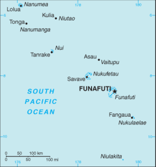
The Western Pacific nation of Tuvalu, formerly known as the Ellice Islands, is situated 4,000 kilometers (2,500 mi) northeast of Australia and is approximately halfway between Hawaii and Australia. It lies east-northeast of the Santa Cruz Islands, southeast of Nauru, south of Kiribati, west of Tokelau, northwest of Samoa and Wallis and Futuna and north of Fiji. It is a very small island country of 26 km2 (10 sq mi). Due to the spread out islands it has the 38th largest Exclusive Economic Zone of 749,790 km2 (289,500 sq mi).

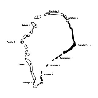
Fongafale is the largest of Funafuti's islets in Tuvalu. It is a long narrow sliver of land, 12 kilometres long and between 10 and 400 metres wide, with the South Pacific Ocean and reef on the east and the protected lagoon on the west. The north part is the Tengako peninsula, and Funafuti International Airport runs from northeast to southwest on the widest part of the island, with the village and administrative centre of Vaiaku on the lagoon side.
Tepuka is an island eighteen kilometers west of Fongafale, in the northwest of Funafuti, the main atoll of the Oceanian nation of Tuvalu. Te puka, or Pouka, is the name of a tree - Hernandia peltata.
Amatuku is an islet of Funafuti, Tuvalu on which the Tuvalu Maritime Training Institute is located. Access to Amatuku is from Tengako, which is the peninsula at the north end of Fongafale islet.
Funafala is an islet of Funafuti, Tuvalu that is inhabited by five families, with a church also located on the islet. Funafala means 'the pandanus of Funa', the name of a chief, after whom also the group has been named Funafuti.
Fuafatu is an islet of Funafuti, Tuvalu, 5.5 miles (8.9 km) north of Tefala.

Fualefeke is a small islet of Funafuti, Tuvalu.
Fualopa is an islet of Funafuti, Tuvalu. It is part of the Funafuti Conservation Area, established in 1996 with the aim of preserving the natural fauna and flora of the area.Fualopa hosts a breeding colony of black noddy.
Funamanu is a small narrow island that is part of Funafuti atoll in Tuvalu. It is a motu (islet) or very small island and is located 2.6 miles southwestward of the southwest tip of Funafuti. The islet is known to be covered in coconut trees which grow 70 feet high. Te Ava Pua Pua is the passage through the reef, with a least depth of 12.7 metres, between the islets of Funamanu to the north and Fale Fatu to the south, in the southeast of Funafuti atoll.
Motuloa is an islet in the atoll of Funafuti, Tuvalu. Motu loa means long island. It lies on the southeastern rim of the atoll and is 800 metres (0.50 mi) long northeast–southwest, but only 50 metres (160 ft) wide. It is only about 25 metres (82 ft) southwest of Telele and can be reached by foot from it during low tide. The islet is densely vegetated.
Te Afuafou is an islet of Funafuti, Tuvalu. Charles Hedley in 1896 describes the meaning of the name 'Te afua fou' as being 'the new beginning':
the name refers to an unfortunate incident in connection with their first contact with the white man, and their first knowledge of the deadly firearms of the foreigner. A vessel called at the mouth of the lagoon, and the natives were allowed on board. On leaving one of them stole a bucket. The canoe. containing the thief was pursued, and, to the astonishment and dismay of the company, the man in pursuit was able to produce lightning and thunder and to inflict death.
Te Afualiku is an islet of Funafuti, Tuvalu. It is the smallest island of Tuvalu.
Telele is an uninhabited islet of Funafuti, Tuvalu. The estimate terrain elevation of the island is 12 metres above sea level.

Tepuka Vili Vili or Tepuka Savilivili is an islet of Funafuti, Tuvalu.
Tutanga is an uninhabited islet which is the most southern islet of Funafuti, Tuvalu. This islet has also been called Tuaeriki.
Vasafua is an islet of Funafuti, Tuvalu. Vasafua is part of the Funafuti Conservation Area, established in 1996 with the aim of preserving the natural fauna and flora of the area.
Fale Fatu is an islet of Funafuti, Tuvalu. Te Ava Pua Pua is the passage through the reef, with a least depth of 12.7 metres, between the islets of Funamanu to the north and Fale Fatu to the south, in the southeast of Funafuti atoll.
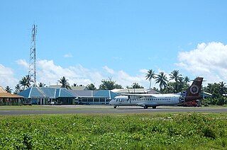
Funafuti is the capital of the island nation of Tuvalu. It has a population of 6,320 people, and so it has more people than the rest of Tuvalu combined, with approximately 60% of the population. It consists of a narrow sweep of land between 20 and 400 metres wide, encircling a large lagoon 18 km long and 14 km wide. The average depth of the Funafuti lagoon is about 20 fathoms. With a surface area of 275 square kilometres (106.2 sq mi), it is by far the largest lagoon in Tuvalu. The land area of the 33 islets around the atoll of Funafuti totals 2.4 square kilometres (0.9 sq mi); taken together, they constitute less than one percent of the total area of the atoll. Cargo ships can enter Funafuti's lagoon and dock at the port facilities on Fongafale.
The Funafuti Conservation Area is a marine conservation area covering 33 square kilometers of reef, lagoon and motu (islets) on the western side of Funafuti atoll in Tuvalu. The marine environment of the conservation area includes reef, lagoon, channel and ocean; and are home to many species of fish, corals, algae and invertebrates. The islets are nesting sites for the green sea turtle and Fualopa hosts a breeding colony of black noddy.
References
- ↑ Admiralty Nautical Chart 2983 Tuvalu - Funafuti atoll. United Kingdom Hydrographic Office (UKHO).
- ↑ Hedley, Charles (1896). General account of the Atoll of Funafuti (PDF). Australian Museum Memoir 3(2): 1–72. p. 17.
| Islands |  | |
|---|---|---|
| Atolls | ||
| Islets of Funafuti | ||
| Islets of Nanumea | ||
| Islets of Nui | ||
| Islets of Nukufetau | ||
| Islets of Vaitupu | ||
8°38′23″S179°04′29″E / 8.6396°S 179.0748°E
| | This Tuvalu location article is a stub. You can help Wikipedia by expanding it. |