
Tuvalu is an island country and microstate in the Polynesian subregion of Oceania in the Pacific Ocean. Its islands are situated about midway between Hawaii and Australia. They lie east-northeast of the Santa Cruz Islands, northeast of Vanuatu, southeast of Nauru, south of Kiribati, west of Tokelau, northwest of Samoa and Wallis and Futuna, and north of Fiji. Tuvalu is composed of three reef islands and six atolls. They are spread out between the latitude of 5° and 10° south and between the longitude of 176° and 180°. They lie west of the International Date Line. Tuvalu has a population of 11,204. The total land area of the islands of Tuvalu is 26 square kilometres (10 sq mi).
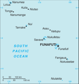
The Western Pacific nation of Tuvalu, formerly known as the Ellice Islands, is situated 4,000 kilometers (2,500 mi) northeast of Australia and is approximately halfway between Hawaii and Australia. It lies east-northeast of the Santa Cruz Islands, southeast of Nauru, south of Kiribati, west of Tokelau, northwest of Samoa and Wallis and Futuna and north of Fiji. It is a very small island country of 26 km2 (10 sq mi). Due to the spread out islands it has the 38th largest Exclusive Economic Zone of 749,790 km2 (289,500 sq mi).
The first inhabitants of Tuvalu were Polynesians, so the origins of the people of Tuvalu can be traced to the spread of humans out of Southeast Asia, from Taiwan, via Melanesia and across the Pacific islands of Polynesia.

Nanumea is the northwesternmost atoll in the Polynesian nation of Tuvalu, a group of nine coral atolls and islands spread over about 400 miles (640 km) of the Pacific Ocean just south of the equator and west of the International Date Line. Nanumea is 4 km2 (1.5 sq mi) with a population of 512 people.
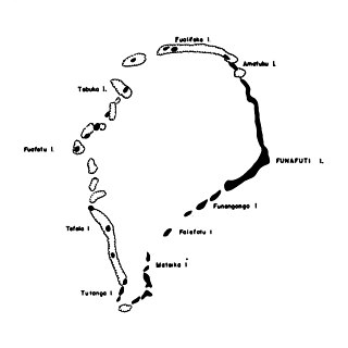
Tepuka is an island eighteen kilometers west of Fongafale, in the northwest of Funafuti, the main atoll of the Oceanian nation of Tuvalu. Te puka, or Pouka, is the name of a tree - Hernandia peltata.
The Congregational Christian Church of Tuvalu, commonly the Church of Tuvalu, is a Christian Church which is the state church of Tuvalu, although this status merely entitles it to "the privilege of performing special services on major national events". Its adherents comprise about 97% of the ~11,000 inhabitants of the archipelago, and theologically, it is part of the Calvinist tradition.
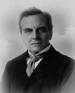
Prof William Johnson Sollas PGS FRS FRSE LLD was a British geologist and anthropologist. After studying at the City of London School, the Royal College of Chemistry and the Royal School of Mines he matriculated to St. John's College, Cambridge, where he was awarded First Class Honours in geology. After some time spent as a University Extension lecturer he became lecturer in Geology and Zoology at University College, Bristol in 1879, where he stayed until he was offered the post of Professor of Geology at Trinity College Dublin. In 1897 he was offered the post of Professor of Geology at the University of Oxford, which he accepted.
Falaoigo is an uninhabited islet of Funafuti, Tuvalu.
Fatato is an uninhabited islet (motu) of Funafuti, Tuvalu. In 2002 the Asia-Pacific Network for Global Change Research (APN) chose this island for a systematic study of its coast in relation to the impact of global climate change on atolls. The islet can be accessed by foot with a 20-30 minute walk from Fongafale across the reef at low tide.
Funafala is an islet of Funafuti, Tuvalu that is inhabited by five families, with a church also located on the islet. Funafala means 'the pandanus of Funa', the name of a chief, after whom also the group has been named Funafuti.
Fuafatu is an islet of Funafuti, Tuvalu, 5.5 miles (8.9 km) north of Tefala.
Funamanu is a small narrow island that is part of Funafuti atoll in Tuvalu. It is a motu (islet) or very small island and is located 2.6 miles southwestward of the southwest tip of Funafuti. The islet is known to be covered in coconut trees which grow 70 feet high. Te Ava Pua Pua is the passage through the reef, with a least depth of 12.7 metres, between the islets of Funamanu to the north and Fale Fatu to the south, in the southeast of Funafuti atoll.
Telele is an uninhabited islet of Funafuti, Tuvalu. The estimate terrain elevation of the island is 12 metres above sea level.
Tengasu is an uninhabited islet of Funafuti, Tuvalu.
Vasafua is an islet of Funafuti, Tuvalu. Vasafua is part of the Funafuti Conservation Area, established in 1996 with the aim of preserving the natural fauna and flora of the area.

Funafuti is the capital of the island nation of Tuvalu. It has a population of 6,320 people, and so it has more people than the rest of Tuvalu combined, with approximately 60% of the population. It consists of a narrow sweep of land between 20 and 400 metres wide, encircling a large lagoon 18 km long and 14 km wide. The average depth of the Funafuti lagoon is about 20 fathoms. With a surface area of 275 square kilometres (106.2 sq mi), it is by far the largest lagoon in Tuvalu. The land area of the 33 islets around the atoll of Funafuti totals 2.4 square kilometres (0.9 sq mi); taken together, they constitute less than one percent of the total area of the atoll. Cargo ships can enter Funafuti's lagoon and dock at the port facilities on Fongafale.
The Funafuti Conservation Area is a marine conservation area covering 33 square kilometers of reef, lagoon and motu (islets) on the western side of Funafuti atoll in Tuvalu. The marine environment of the conservation area includes reef, lagoon, channel and ocean; and are home to many species of fish, corals, algae and invertebrates. The islets are nesting sites for the green sea turtle and Fualopa hosts a breeding colony of black noddy.

Tuvaluan mythology tells stories of the creation of the islands of Tuvalu and of the founding ancestors of each island. While on some of the islands there are stories of spirits creating the islands, a creation story that is found on many of the islands is that te Pusi mo te Ali created the islands of Tuvalu; te Ali is believed to be the origin of the flat atolls of Tuvalu and te Pusi is the model for the coconut palms that are important in the lives of Tuvaluans. The strength of this belief has the consequence that Moray eel are tapu and are not eaten.

The coral reefs of Tuvalu consist of three reef islands and six atolls, containing approximately 710 km2 (270 sq mi) of reef platforms. The islands of the Tuvalu archipelago are spread out between the latitude of 5° to 10° south and longitude of 176° to 180°, west of the International Date Line. The islands of Tuvalu are volcanic in origin. On the atolls, an annular reef rim surrounds the lagoon, and may include natural reef channels. The reef islands have a different structure to the atolls, and are described as reef platforms as they are smaller tabular reef platforms that do not have a salt-water lagoon, although they may have a completely closed rim of dry land, with the remnants of a lagoon that has no direct connection to the open sea or that may be drying up.

