Fenua Tapu is an islet of Nui atoll in the Pacific Ocean state of Tuvalu. [1] [2]
It is the most southern and most eastern islet of Nui and is the largest (area 1.38 km2). Most Nuians live on the western end of Fenua Tapu, [3] where a village including the settlements of Alamoni - Maiaki and Manutalake - Meang (Tanrake) lies. [4]
A Dutch expedition (the frigate Maria Reigersberg [5] ) found Nui on the morning of June 14, 1825 and named Fenua Tapu as Nederlandsch Eiland. [6]
A New Island in the Pacific.— In July last, the Pollux, Dutch sloop of war, Captain Eeg, discovered a new and well-peopled island in the Pacific, to which the name of Nederlandich Island was given : its latitude and longitude laid down at 7° 10' S., and 177° 33' 16" E. from Greenwich. The natives were athletic and fierce, great thieves, and, from their shewing no symptoms of fear when muskets were discharged, evidently unacquainted with the effects of fire-arms. [7]
 Dutch map of the island, made in June 1825
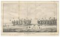 View of the main island
 View of the atoll


