Tuvalu is an island country in the Polynesian subregion of Oceania in the Pacific Ocean, about midway between Hawaii and Australia. It lies east-northeast of the Santa Cruz Islands, northeast of Vanuatu, southeast of Nauru, south of Kiribati, west of Tokelau, northwest of Samoa and Wallis and Futuna, and north of Fiji.
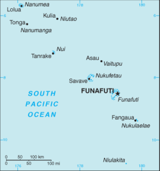
The Western Pacific nation of Tuvalu, formerly known as the Ellice Islands, is situated 4,000 kilometers (2,500 mi) northeast of Australia and is approximately halfway between Hawaii and Australia. It lies east-northeast of the Santa Cruz Islands, southeast of Nauru, south of Kiribati, west of Tokelau, northwest of Samoa and Wallis and Futuna and north of Fiji. It is a very small island country of 26 km2 (10 sq mi). Due to the spread out islands it has the 38th largest Exclusive Economic Zone of 749,790 km2 (289,500 sq mi). In terms of size, it is the second-smallest country in Oceania.
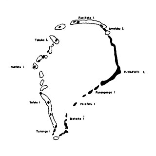
Tepuka is an island eighteen kilometers west of Fongafale, in the northwest of Funafuti, the main atoll of the Oceanian nation of Tuvalu. Te puka, or Pouka, is the name of a tree - Hernandia peltata.
Amatuku is an islet of Funafuti, Tuvalu on which the Tuvalu Maritime Training Institute is located. Access to Amatuku is from Tengako, which is the peninsula at the north end of Fongafale islet.

Falaoigo is an uninhabited islet of Funafuti, Tuvalu. It is located in the southwestern part of the atoll next to Tutanga another one of the islets in the atoll. On Google Earth it is labeled as "Te Afuafou".
Funafala is an islet of Funafuti, Tuvalu that is inhabited by five families, with a church also located on the islet. Funafala means 'the pandanus of Funa', the name of a chief, after whom also the group has been named Funafuti.
Fuafatu is an islet of Funafuti, Tuvalu, 5.5 miles (8.9 km) north of Tefala.
Fuagea is an islet located in the archipelago of Tuvalu in the south-western part of the atoll of Funafuti.
Fualopa is an islet of Funafuti, Tuvalu. It is part of the Funafuti Conservation Area, established in 1996 with the aim of preserving the natural fauna and flora of the area. Fualopa hosts a breeding colony of black noddy.
Funamanu is a small narrow island that is part of Funafuti atoll in Tuvalu. It is a motu (islet) or very small island and is located 2.6 miles southwestward of the southwest tip of Funafuti. The islet is known to be covered in coconut trees which grow 70 feet high. Te Ava Pua Pua is the passage through the reef, with a least depth of 12.7 metres, between the islets of Funamanu to the north and Fale Fatu to the south, in the southeast of Funafuti atoll.
Mateika or Mateiko is an uninhabited islet of Funafuti, Tuvalu.
Motuloa is an islet in the atoll of Funafuti, Tuvalu. Motu loa means long island. It lies on the southeastern rim of the atoll and is 800 metres (0.50 mi) long northeast–southwest, but only 50 metres (160 ft) wide. It is only about 25 metres (82 ft) southwest of Telele and can be reached by foot from it during low tide. The islet is densely vegetated.
Te Afualiku is an islet of Funafuti, Tuvalu. It is the smallest island of Tuvalu.
Telele is an uninhabited islet of Funafuti, Tuvalu. The estimate terrain elevation of the island is 12 metres above sea level.
Tepuka Vili Vili or Tepuka Savilivili is an islet of Funafuti, Tuvalu.
Vasafua is an islet of Funafuti, Tuvalu. Vasafua is part of the Funafuti Conservation Area, established in 1996 with the aim of preserving the natural fauna and flora of the area.

Tengako is a peninsula at the north end of Fongafale islet of Funafuti, Tuvalu. At the end of the peninsula is Amatuku islet on which the Tuvalu Maritime Training Institute is located.
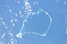
Funafuti is an atoll, comprising numerous islets, that serves as the capital of Tuvalu. As of the 2017 census, it has a population of 6,320 people. More people live in Funafuti than the rest of Tuvalu combined, with it containing approximately 60% of the nation's population. The main islet, Fongafale, hosts Vaiaku, the administrative center of the nation.
The Funafuti Conservation Area is a marine conservation area covering 33 square kilometers of reef, lagoon and motu (islets) on the western side of Funafuti atoll in Tuvalu. The marine environment of the conservation area includes reef, lagoon, channel and ocean; and are home to many species of fish, corals, algae and invertebrates. The islets are nesting sites for the green sea turtle and Fualopa hosts a breeding colony of black noddy.

The coral reefs of Tuvalu consist of three reef islands and six atolls, containing approximately 710 km2 (270 sq mi) of reef platforms. The islands of the Tuvalu archipelago are spread out between the latitude of 5° to 10° south and longitude of 176° to 180°, west of the International Date Line. The islands of Tuvalu are volcanic in origin. On the atolls, an annular reef rim surrounds the lagoon, and may include natural reef channels. The reef islands have a different structure to the atolls, and are described as reef platforms as they are smaller tabular reef platforms that do not have a salt-water lagoon, although they may have a completely closed rim of dry land, with the remnants of a lagoon that has no direct connection to the open sea or that may be drying up.