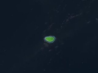
Motutanifa or Motu o tanifa is an uninhabited islet of Vaitupu, Tuvalu, [1] [2] which is located on the reef to the north of the part of Vaitupu known as Muli. [3]

Tuvalu is an island country in the Polynesian subregion of Oceania, surrounded by the Pacific Ocean and situated about midway between Hawaii and Australia. The country lies east-northeast of the Santa Cruz Islands, northeast of Vanuatu, southeast of Nauru, south of Kiribati, west of Tokelau, northwest of Samoa and Wallis and Futuna, and north of Fiji. It is composed of three reef islands and six atolls spread out between the latitude of 5° to 10° south and longitude of 176° to 180°, west of the International Date Line. Tuvalu has a population of 10,507. The total land area of the islands of Tuvalu is 26 square kilometres (10 sq mi).
The first inhabitants of Tuvalu were the Polynesians, so the origins of the people of Tuvalu can be traced to the spread of humans out of Southeast Asia, from Taiwan, via Melanesia and across the Pacific islands of Polynesia.

Vaitupu is the largest atoll of the nation of Tuvalu. It is located at 7.48 degrees south and 178.83 degrees west. There are 1,061 people living on 5.6 square kilometres with the main village being Asau.
Niulakita is the southernmost island of Tuvalu, and also the name of the only village on this island. Niulakita has a population of 34. The residents of Niulakita have moved to the island from Niutao. Niulakita is represented in the Parliament of Tuvalu by the members of the constituency of Niutao.
Motuloa or Motulua is a very small island on the north of Nukufetau in Tuvalu. It is an oval with a length of 200 m, and lies between Teafuanonu and Teafuaniua.

Alfred Thomas Agate was a noted American artist, painter and miniaturist.
Matanukulaelae is an uninhabited islet of Nukufetau, Tuvalu. The estimate elevation above sea level is 5 meters.
Tea fuanonu is an uninhabited islet on the north-east of Nukufetau atoll, Tuvalu.
Teafuone is an islet of Nukufetau, Tuvalu. Teafuone has also been known as Entrance Island as it is by the channel through the reef of Nukufetau.
Oua is an islet on the north-east of Nukufetau atoll, Tuvalu, next to Lafanga atoll.
Teafatule is an uninhabited islet of Nukufetau, Tuvalu.
Luasamotu is an uninhabited islet of Vaitupu, Tuvalu. Luasamotu on the reef off the eastern part of Vaitupu known as Matangi.
Te Motu Olepa is an islet of Vaitupu, Tuvalu that is between the Isles of Mosana and Luasamotu.
Tofia is a small islet of Vaitupu, Tuvalu, in the entrance to the lagoon.
The Isles of Mosana are the two small islets of Vaitupu, Tuvalu.
Temotu is an islet of Vaitupu, Tuvalu. Temotu village which has a current population of 52 inhabitants resides on the islet. The average elevation of Temotu Village is 1 meter.
Neli Lifuka was born in 1909 on Vaitupu, he worked as a marine engineer and from 1945 to 1951 he was the magistrate on Vaitupu. He organised the collection of the funds necessary to purchase Kioa island in Fiji in 1946 and in 1956 he joined the Kioa community and became the chairman of the council.

Donald Gilbert Kennedy was a teacher, then an administrator in the British colonial service in the Gilbert and Ellice Islands Colony and the British Solomon Islands Protectorate. For his services as a Coastwatcher during the Pacific War, he was awarded the DSO, and the Navy Cross (U.S.). He published journal articles and books on the material culture of Vaitupu atoll, land tenure and the language of the Ellice Islands.
King George V School (KGV) was a government high school for boys in the Gilbert Islands, within the British colony Gilbert and Ellice Islands. Throughout its history it was in multiple locations in South Tarawa and Abemama. It served as a boarding school, and trained people to be government workers and teachers.
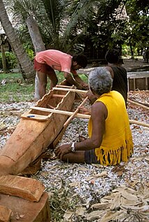
A paopao, is the name used by the Polynesian-speaking inhabitants of the Ellice Islands for their single-outrigger canoes, of which the largest could carry four to six adults. The large double-hulled sailing-canoes had ceased to be constructed in the Ellice Islands some time before contact with Europeans.
| Islands |  | |
|---|---|---|
| Atolls | ||
| Islets of Funafuti | ||
| Islets of Nanumea | ||
| Islets of Nui | ||
| Islets of Nukufetau | ||
| Islets of Vaitupu | ||
Coordinates: 7°28′07″S178°40′44″E / 7.4687°S 178.6789°E
| This Tuvalu location article is a stub. You can help Wikipedia by expanding it. |