Génis Unit

Last updated

The Génis Unit is a Paleozoic metasedimentary succession of the southern Limousin and belongs geologically to the Variscan basement of the French Massif Central. The unit covers the age range Cambrian/Ordovician till Devonian.

The PaleozoicEra is the earliest of three geologic eras of the Phanerozoic Eon. It is the longest of the Phanerozoic eras, lasting from 541 to 251.902 million years ago, and is subdivided into six geologic periods : the Cambrian, Ordovician, Silurian, Devonian, Carboniferous, and Permian. The Paleozoic comes after the Neoproterozoic Era of the Proterozoic Eon and is followed by the Mesozoic Era.

Variscan orogeny

The Variscan or Hercynianorogeny is a geologic mountain-building event caused by Late Paleozoic continental collision between Euramerica (Laurussia) and Gondwana to form the supercontinent of Pangaea.

France Republic with mainland in Europe and numerous oversea territories

France, officially the French Republic, is a country whose territory consists of metropolitan France in Western Europe and several overseas regions and territories. The metropolitan area of France extends from the Mediterranean Sea to the English Channel and the North Sea, and from the Rhine to the Atlantic Ocean. It is bordered by Belgium, Luxembourg and Germany to the northeast, Switzerland and Italy to the east, and Andorra and Spain to the south. The overseas territories include French Guiana in South America and several islands in the Atlantic, Pacific and Indian oceans. The country's 18 integral regions span a combined area of 643,801 square kilometres (248,573 sq mi) and a total population of 67.3 million. France, a sovereign state, is a unitary semi-presidential republic with its capital in Paris, the country's largest city and main cultural and commercial centre. Other major urban areas include Lyon, Marseille, Toulouse, Bordeaux, Lille and Nice.

Contents

Type locality

The Génis Unit was named after its type locality, the small town Génis, situated in the northeastern Dordogne.

Type locality, also called type area, or type section, is the locality where a particular rock type, stratigraphic unit or mineral species is first identified. If the stratigraphic unit in a locality is layered, it is called a stratotype, whereas the standard of reference for unlayered rocks is the type locality.

Génis Commune in Nouvelle-Aquitaine, France

Génis is a commune in the Dordogne department in Nouvelle-Aquitaine in southwestern France.

Geographical Occurrence

The canyon of the Auvezere between Genis and Saint-Mesmin exposes here mainly the Genis porphyroid. In the background the peneplained plateau of the Bas Limousin with the Thiviers-Payzac Unit. Auvezere (et Forge) gorges (1).JPG
The canyon of the Auvézère between Génis and Saint-Mesmin exposes here mainly the Génis porphyroid. In the background the peneplained plateau of the Bas Limousin with the Thiviers-Payzac Unit.

The Génis Unit occurs in an elongated strip at the northeastern edge of the Dordogne department, following a WNW-ESE direction for about 26 kilometres. Its width across strike is not more than 5 kilometres. The unit forms part of the Bas Limousin, a basement plateau that was peneplained during the Paleogene. The plateau's elevation oscillates between 300 and 400 meters. Geologically the unit's northern limit is the South Limousin Fault, a very important ductile, dextral wrench fault separating the Génis Unit from the Thiviers-Payzac Unit to the north. To the south the unit is overlain by liassic sediments of the Aquitaine Basin. In the east the group disappears beneath Permian red beds of the Brive Basin. Its sedimentary succession can be best studied along the Auvézère river.

Basement below-ground floor of a building

A basement or cellar is one or more floors of a building that are either completely or partially below the ground floor. They are generally used as a utility space for a building where such items as the boiler, water heater, breaker panel or fuse box, car park, and air-conditioning system are located; so also are amenities such as the electrical distribution system, and cable television distribution point. However, in cities with high property prices such as London, basements are often fitted out to a high standard and used as living space.

Peneplain A low-relief plain formed by protracted erosion

In geomorphology and geology a peneplain is a low-relief plain formed by protracted erosion. This is the definition in the broadest of terms, albeit with frequency the usage of peneplain is meant to imply the representation of a near-final stage of fluvial erosion during times of extended tectonic stability. Peneplains are sometimes associated with the cycle of erosion theory of William Morris Davis, but Davis and other workers have also used the term in a purely descriptive manner without any theory or particular genesis attached.

The Paleogene is a geologic period and system that spans 43 million years from the end of the Cretaceous Period 66 million years ago (Mya) to the beginning of the Neogene Period 23.03 Mya. It is the beginning of the Cenozoic Era of the present Phanerozoic Eon. The Paleogene is most notable for being the time during which mammals diversified from relatively small, simple forms into a large group of diverse animals in the wake of the Cretaceous–Paleogene extinction event that ended the preceding Cretaceous Period. The United States Geological Survey uses the abbreviation PE for the Paleogene, but the more commonly used abbreviation is PG with the PE being used for Paleocene.

Comparable units to the Génis Unit with an identical stratigraphic succession can be found in the Vendée and in the Rouergue. [1]

Vendée Department of France

The Vendée is a department in the Pays-de-la-Loire region in west-central France, on the Atlantic Ocean. The name Vendée is taken from the Vendée river which runs through the southeastern part of the department.

Rouergue province of France

Rouergue is a former province of France, corresponding roughly with the modern department of Aveyron. Its historical capital is Rodez. It is bounded on the north by Auvergne, on the south and southwest by Languedoc, on the east by Gévaudan and on the west by Quercy.

Stratigraphy

The Génis Unit shows the following stratigraphic succession (from top to bottom):

Génis greenschist

The Génis greenschist is the youngest formation of the Génis Unit. The greenschist derives from mafic magmatic rocks like gabbro and basaltic pillow lava, basic volcanoclastics and rare intercalations of chert and pelite. A lower Devonian age can be attributed to the greenschist.

Mafic Silicate mineral or igneous rock that is rich in magnesium and iron

Mafic is an adjective describing a silicate mineral or igneous rock that is rich in magnesium and iron, and is thus a portmanteau of magnesium and ferric. Most mafic minerals are dark in color, and common rock-forming mafic minerals include olivine, pyroxene, amphibole, and biotite. Common mafic rocks include basalt, diabase and gabbro. Mafic rocks often also contain calcium-rich varieties of plagioclase feldspar.

Gabbro A coarse-grained mafic intrusive rock

Gabbro is a phaneritic (coarse-grained), mafic intrusive igneous rock formed from the slow cooling of magnesium-rich and iron-rich magma into a holocrystalline mass deep beneath the Earth's surface. Slow-cooling, coarse-grained gabbro is chemically equivalent to rapid-cooling, fine-grained basalt. Much of the Earth's oceanic crust is made of gabbro, formed at mid-ocean ridges. Gabbro is also found as plutons associated with continental volcanism. Due to its variant nature, the term "gabbro" may be applied loosely to a wide range of intrusive rocks, many of which are merely "gabbroic".

Basalt A magnesium- and iron-rich extrusive igneous rock

Basalt is a mafic extrusive igneous rock formed from the rapid cooling of magnesium-rich and iron-rich lava exposed at or very near the surface of a terrestrial planet or a moon. More than 90% of all volcanic rock on Earth is basalt. Basalt lava has a low viscosity, due to its low silica content, resulting in rapid lava flows that can spread over great areas before cooling and solidification. Flood basalt describes the formation in a series of lava basalt flows.

Incorporated at the base of the greenschist are limestone lenses containing upper Silurian conodonts. [2]

Génis sericite schist

The underlying Génis sericite schist is very rich in the minerals quartz, chlorite and muscovite (variety sericite). The sericite schist is probably of Ordovician and lower Silurian age (rare finds of Ordovician acritarchs have been made).

Puy-de-Cornut arkose

Below the Génis sericite schist follows the Puy-de-Cornut arkose. The arkose is strongly silicified and forms erosionally resistant morphological ridges. It is supposed to be an equivalent of the Puy-des-Âges quartzite from the neighbouring Thiviers-Payzac Unit. A close relationship with the Grès Armoricain in Brittany is also considered. Therefore an Ordovician age of the arkose is most likely.

Génis porphyroid

Sawn sample of the Genis porphyroid showing a dextral shear sense. Genis porphyroid.jpg
Sawn sample of the Génis porphyroid showing a dextral shear sense.

Below a pronounced angular unconformity one encounters the Génis porphyroid. This rock represents alkaline, rhyolitic ignimbrites (metaignimbrites) of lower Ordovician age (Tremadocian). Its mineralogy is composed of phenocrysts of quartz, alkali feldspar and plagioclase (albite) and a very fine-grained matrix (grain-size 5 μ) made of quartz, feldspars, sericite and rare chlorite. Original fiamme are hard to discern, but welded glassy layers are recognisable. The metaignimbrite is rich in potassium and contains more than 70% of SiO2.

Underlying the Génis porphyroid are the Donzenac schist and the Thiviers sandstone, the main formations of the Thiviers-Payzac Unit. In the Fugeyrollas anticline the Thiviers sandstone appears on the surface and thus also crops out within the Génis Unit. Both formations are supposed to cover the age range Neoproterozoic to Cambrian.

Structural organisation

The Génis Unit is thoroughly folded into tight, upright folds with a wavelength of about 150 meters. The fold axes strike WNW-ESE (N 110) with a slight dip of about 10 ° to the east. The original sedimentary layering (S0) can often still be recognised dipping 75 to 80 ° to the north or to the south. Parallel to the folds' axial plane a distinct schistosity has developed (S1). The tight folds are overprinted by secondary folding and deformed into large anticlines and synclines with a wavelength of about 2 kilometers (Cubas syncline in the south followed by the Fougeyrollas anticline and the Génis syncline to the north). Imprinted on the layering are well developed stretching lineations also running more or less parallel to the fold axes. Newly formed metamorphic minerals are preferably arranged along this direction, although their lineations stray between N 110 and N 135. Furthermore the lineations are accompanied by microfolds, whose axes yet again follow the N 110-direction.

Metamorphism and structural evolution

During the Variscan orogeny the original sedimentary succession of the Génis Unit subsided and was metamorphosed due to increasing overburden. The metamorphism followed a retrograde path (neoformation of chlorite) and recorded the epizonal conditions of the greenschist facies. This fact is very important for the geology of the Massif Central, because low-grade metamorphic successions are underrepresented and quite rare. Usually the metasediments in the Massif Central are strongly deformed and metamorphosed (under amphibolite facies conditions) and therefore only rough guesses can be made about their protoliths.

The retrograde metamorphism is known in other places of the Massif Central and is assigned a mid-Carboniferous age. [3]

Like the already mentioned South Limousin Fault the entire Génis Unit underwent ductile, dextral wrenching and can thus be conceived as a fairly wide, upright, WNW-ESE-striking shear zone. Dextral shear criteria can be found in all of its formations. Asymmetrically deformed quartz pebbles in conglomeratic layers of the Thiviers sandstone indicate dextral shearing. The same sense of movement is even more evident in the Génis porphyroid, where pressure shadows have formed around the quartz and alkali feldspar phenocrysts. Millimetre-sized shear bands within the Génis sericite schist also point at dextral shearing. [4]

The timing of the shearing motions is based on comparisons with similar terrains in the Armorican Massif (Chantonnay synform in the Vendée) and in the Rouergue. The dextral shearing in the Armorican Massif is dated as Namurian and Westphalian (Serpukhovian till Moscovian), i.e. 325 to 305 million years ago. It is therefore reasonable to assume a mid- to late Carboniferous age for the deformations in the Génis Unit of the southern Limousin.

The pervasive shearing motions are also responsible for the fold structures in the Génis Unit, which can be interpreted as tear folds caused by the transpressive, ductile wrenching.

Related Research Articles

Saint-Paul-la-Roche Commune in Nouvelle-Aquitaine, France

Saint-Paul-la-Roche, in Occitan Sent Pau la Ròcha, is a commune in the northeast of the Dordogne department in the Nouvelle-Aquitaine region in southwestern France. The commune is integrated into the Regional Natural Parc Périgord Limousin.

Geology of Andorra

Andorra is located in the Axial Zone of the central Pyrenees mountain range in south western Europe, which means that it has intensely folded and thrusted rocks formed when the Iberian peninsula was rotated onto the European continent.

Aquitaine Basin Mesozoic and Cenozoic sedimentary basin in France

The Aquitaine Basin is, after the Paris Basin, the second largest Mesozoic and Cenozoic sedimentary basin in France, occupying a large part of the country's southwestern quadrant. Its surface area covers 66,000 km2 onshore. It formed on Variscan basement which was peneplained during the Permian and then started subsiding in the early Triassic. The basement is covered in the Parentis Basin and in the Subpyrenean Basin—both sub-basins of the main Aquitaine Basin—by 11,000 m of sediment.

The South Pass greenstone belt is located within the Wyoming craton in the US. The region was the site of Wyoming's initial gold discovery in 1842.

The Parc naturel régional Périgord Limousin was created March 9, 1998. It consists of 78 communes situated in the Dordogne and Haute Vienne départements. The park has a surface area of 1800 square kilometers and is inhabited by 49 661 people.

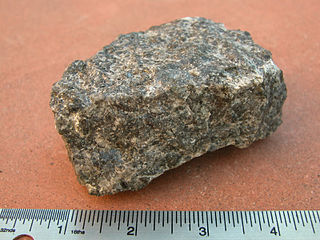
The Piégut-Pluviers Granodiorite is situated at the northwestern edge of the Variscan Massif Central in France. Its cooling age has been determined as 325 ± 14 million years BP.

The Massif Central is one of the two large basement massifs in France, the other being the Armorican Massif. The Massif Central's geological evolution started in the late Neoproterozoic and continues to this day. It has been shaped mainly by the Caledonian orogeny and the Variscan orogeny. The Alpine orogeny has also left its imprints, probably causing the important Cenozoic volcanism. The Massif Central has a very long geological history, underlined by zircon ages dating back into the Archaean 3 billion years ago. Structurally it consists mainly of stacked metamorphic basement nappes.

Geology of the Pyrenees

The Pyrenees are a 430-kilometre-long, roughly east–west striking, intracontinental mountain chain that divide France, Spain, and Andorra. The belt has an extended, polycyclic geological evolution dating back to the Precambrian. The chain's present configuration is due to the collision between the microcontinent Iberia and the southwestern promontory of the European Plate. The two continents were approaching each other since the onset of the Upper Cretaceous (Albian/Cenomanian) about 100 million years ago and were consequently colliding during the Paleogene (Eocene/Oligocene) 55 to 25 million years ago. After its uplift, the chain experienced intense erosion and isostatic readjustments. A cross-section through the chain shows an asymmetric flower-like structure with steeper dips on the French side. The Pyrenees are not solely the result of compressional forces, but also show an important sinistral shearing.

The Canaveilles Group is the basal metasedimentary succession of late Neoproterozoic and Cambrian age outcropping in the Pyrenees.

The Thiviers-Payzac Unit is a metasedimentary succession of late Neoproterozoic and Cambrian age outcropping in the southern Limousin in France. The unit geologically forms part of the Variscan basement of the northwestern Massif Central.

The Mareuil Anticline, also called Mareuil-Meyssac Anticline, is a structural high within the sedimentary sequence of the northeastern Aquitaine Basin. The northwest-southeast trending anticline was caused by tectonic movements probably starting in the Upper Cretaceous.

The La Tour-Blanche Anticline, also called Chapdeuil Anticline or Chapdeuil-La Tour-Blanche Anticline, is a tectonically caused, dome-like upwarp in the sedimentary succession of the northeastern Aquitaine Basin in France. The structure is oriented west-northwest-east-southeast.

The Neuil Mine, in French Mine de Neuil, is a mine emplaced in paragneisses of the northwestern Massif Central. The mine is part of the commune of Saint-Pardoux-la-Rivière in the Dordogne. Extracted from the mine was galena, slightly enriched in silver.

The Merlis Serpentinites are an aligned group of small serpentinite outcrops in the northwestern French Massif Central. Their parent rocks were peridotites from the upper mantle.

Saint-Mathieu Dome

The Saint-Mathieu dome is a dome-like upwarp in the metamorphic basement of the northwestern French Massif Central. It exposes a very deep and normally hidden parautochthonous unit at the surface.

Hajigak mining concession in Maidan Wardak and Bamyan, Afghanistan

Hajigak Mine is the best known and largest iron oxide deposit in Afghanistan, located near the Hajigak Pass, with its area divided between Maidan Wardak and Bamyan provinces. It has the biggest untapped iron ore deposits of Asia.

Geology of the Democratic Republic of the Congo

The geology of the Democratic Republic of the Congo, commonly abbreviated as DRC, also known as Congo-Kinshasa and formerly as Zaire and Belgian Congo, is extremely old, on the order of several billion years for many rocks. The country spans the Congo Craton: a stable section of ancient continental crust, deformed and influenced by several different mountain building orogeny events, sedimentation, volcanism and the geologically recent effects of the East Africa Rift System in the east. The country's complicated tectonic past have yielded large deposits of gold, diamonds, coltan and other valuable minerals.

The geology of Niger comprises very ancient igneous and metamorphic crystalline basement rocks in the west, more than 2.2 billion years old formed in the late Archean and Proterozoic eons of the Precambrian. The Volta Basin, Air Massif and the Iullemeden Basin began to form in the Neoproterozoic and Paleozoic, along with numerous ring complexes, as the region experienced events such as glaciation and the Pan-African orogeny. Today, Niger has extensive mineral resources due to complex mineralization and laterite weathering including uranium, molybdenum, iron, coal, silver, nickel, cobalt and other resources.

Geology of Belarus

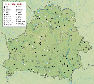
The geology of Belarus began to form more than 2.5 billion years ago in the Precambrian, although many overlying sedimentary units deposited during the Paleozoic and the current Quaternary. Belarus is located in the eastern European plain. From east to west it covers about 650 kilometers while from north to south it covers about 560 kilometers, and the total area is about 207,600 square kilometers. It borders Poland in the north, Lithuania in the northwest, Latvia and Russia in the north, and Ukraine in the south. Belarus has a planar topography with a height of about 160 m above sea level. The highest elevation at 346 meters above sea level is Mt. Dzerzhinskaya, and the lowest point at the height of 80 m is in the Neman River valley. Belarus has a temperate continental climate with the warmest month being July, while the coldest month is January with temperatures plunging to as low as -36°C to -44°C.

Geology of North Macedonia

The geology of North Macedonia includes the study of rocks dating to the Precambrian and a wide-array of volcanic, sedimentary and metamorphic rocks formed in the last 541 million years.

References

  1. Collomb, P. (1970). Étude géologique du Rouergue cristallin. Mem. Serv. Carte Géol. p. 419
  2. Guillot, PL. & Lefebvre, J.|J. (1975). Découverte de conodontes dans le calcaire à entroques de Génis en Dordogne (série métamorphique du Bas Limousin). C. R. Acad. Sci., 280, pp.1529-1530
  3. Faure, M. & Pons, J.|J. (1991). Crustal thinning recorded by the shape of the Namurian-Westphalian leucogranite in the Variscan belt of the Northwest Massif Central, France. Geology, 19, pp. 730-733
  4. Roig, J.-Y., Faure, M. & Ledru, P. (1996). Polyphase wrench tectonics in the southern french Massif Central: kinematic inferences from pre- and syntectonic granitoids. Geologische Rundschau, 85, pp. 138-153

Sources