The terrain of Chad in central Africa is dominated by the low-lying Chad Basin, which rises gradually to mountains and plateaus on the north, east, and south. In the east heights of more than 900 metres are attained in the Ennedi and Ouaddaï plateaus. The greatest elevations are reached in the Tibesti massif in the north, with a maximum height of 3,415 metres at Emi Koussi. The northern half of the republic lies in the Sahara. The Bodélé Depression is a low region in the southern Sahara that is surrounded by basalt mountain ridges. Winds flow through this region and lift dust. The dust from this region supplies over half of the dust to Amazon rainforests.
Energy in Benin is derived from multiple sources, including, oil and natural gas.

The geology of Togo is largely of gneisses and granitic rocks of Proterozoic age in the central and southern part of the country. These are overlain in the coastal zone by Cretaceous and Cenozoic sediments. The northern part of the country has a basement of Neoproterozoic metamorphic rocks and Paleoproterozoic granite. The south of the country is covered in sedimentary basins, covering 3,300 km.2 of land. The West African Craton is made up of crystalline structures, ranging in age from the Neoarchean to the Paleoproterozoic age. The North-Dapaong zone, which is located in the West African Craton, migmatites, gneisses, amphibolites, granodiorites and granites are commonly found. The Neoproterozoic Volta Basin contains sedimentary formations on the Birrimian bedrocks. These sedimentary formations are divided into two groups: an intra-tillite group and a supra-tillite group.
The geology of Egypt includes rocks from Archaean - early Proterozoic times onwards. These oldest rocks are found as inliers in Egypt’s Western Desert. In contrast, the rocks of the Eastern Desert are largely late Proterozoic in age. Throughout the country this older basement is overlain by Palaeozoic sedimentary rocks. Cretaceous rocks occur commonly whilst sediments indicative of repeated marine transgression and regression are characteristic of the Cenozoic Era.
The geological basement of the central and eastern regions Equatorial Guinea is composed of Precambrian rocks which form a part of the Congo craton. They include gneiss, greenstone, schist-amphibolite and granitoids. These older rocks are overlain by sedimentary rocks of Mesozoic, Neogene and Quaternary age in the west and along the coast. The islands of Pagalu and Bioko are of relatively recent volcanic origin, forming a part of the Cameroon Volcanic Line.
The geology of Algeria is diverse; the country divides into three different tectono-stratigraphic domains. In the south and west is the West African Craton which consists of Precambrian granitic basement and surrounding Neoproterozoic mobile belts. Further south the Tuareg Shield comprises the Hoggar, Adrar des Iforas and Air sub-shields which have each been affected by tectono-thermal events touching much of the continent. In the north are the Alpine chain mountains with a succession of folded and over-thrusted strata.

The geology of Angola includes large areas of Precambrian age rocks. The west of the country is characterized by meta-sedimentary rocks of Proterozoic age including tillites assigned to the Bembe System. Overlying these are a thick pile of limestones and other marine sediments laid down during the Mesozoic and Cenozoic eras. Amidst the Proterozoic sequence are areas of crystalline basement dating from the Archaean. More Archaean basement rocks form the Kasai Craton in northeastern Angola. In the north, within the Cassanje Graben are clastic sediments and volcanic rocks of the Karoo Supergroup. Kimberlites and carbonatites resulting from magmatic activity during the Karoo period are found along a northeast-southwest line through the country. Continental sediments of the Kalahari Group are widespread in eastern Angola.
The geology of Botswana plays a significant part in the country’s economy. The basement rocks of the Kaapvaal-Zimbabwe craton extend into Botswana whilst in the east and southeast, metamorphic rocks of Archaean age are dominant. A younger cover of Karoo rocks and post-Cretaceous Kalahari Group sediments conceal the western margins of these older rocks and largely conceal Proterozoic orogenic belts too. This younger stratum was laid down in the Kalahari Basin underlying large parts of the centre of the country. In the northwest of Botswana, more recent sediments overlie rocks of Meso- and Neoproterozoic age rocks, belonging probably to the Damara Belt.
The geology of Burkina Faso is dominated by Precambrian rocks of the Guinea Rise, a dome of Archaean rocks, composed largely of migmatites, gneisses and amphibolites, over which lie the greenstone belts of the early Proterozoic age. The latter are metasediments and metavolcanics assigned largely to the Birimian Supergroup, a suite of rocks in which economically significant mineralization occurs. Pre-Birimian migmatites, gneisses, and amphibolites, located under the Birimian rocks, are the oldest rocks in the country. The Birimian deposits in the southwestern part of the country are typically divided between clastic and volcano-clastic formations.

The geology of Zimbabwe in southern Africa is centered on the Zimbabwe Craton, a core of Archean basement composed in the main of granitoids, schist and gneisses. It also incorporates greenstone belts comprising mafic, ultramafic and felsic volcanics which are associated with epiclastic sediments and iron formations. The craton is overlain in the north, northwest and east by Proterozoic and Phanerozoic sedimentary basins whilst to the northwest are the rocks of the Magondi Supergroup. Northwards is the Zambezi Belt and to the east the Mozambique Belt. South of the Zimbabwe Craton is the Kaapvaal Craton separated from it by the Limpopo Mobile Belt, a zone of deformation and metamorphism reflecting geological events from Archean to Mesoproterozoic times. The Zimbabwe Craton is intruded by an elongate ultramafic/mafic igneous complex known as the Great Dyke which runs for more than 500 km along a SSW/NNE oriented graben. It consists of peridotites, pyroxenites, norites and bands of chromitite.
The geology of Eritrea in east Africa broadly consists of Precambrian rocks in the west, Paleozoic glacial sedimentary rocks in the South and Cenozoic sediments and volcanics along the coastal zone adjoining the Red Sea. The Precambrian rocks been involved with the orogeny process, which is when a section of the Earth's crust is deformed to form a mountain range. Mesozoic sediments in the Danakil and Aysha horsts, which are raised blocks of the Earth's crust that have been lifted, were deformed. The older rocks include meta-sediments and older gneissic basement belonging to different Proterozoic terranes. Mesozoic sediments of marine origin occur in the coastal area along the Red Sea. A number of thin Miocene age basalt flows occur within the sediments of this zone whilst the basalts of the Aden Series date from Pliocene to Holocene times, some being extruded at the time of a major phase of uplift and rifting during the Pleistocene.
The geology of Burundi consists largely of metamorphic rocks of Proterozoic age with inliers of basement rocks of Archaean age. The former are metasediments of the Burundian and Malagaarasian Supergroups which are of Meso- and Neoproterozoic age, respectively. Granites intrude the rocks from the Burndian Supergroup along a 350km zone of mafic and ultramafic intrusions. Just like Tanzania, the Malagarasian Supergroup has Neoproterozoic rocks. The top of this group contains the Kibago Group, which consists of sandstones, quartzites, shales, and a basal conglomerate.
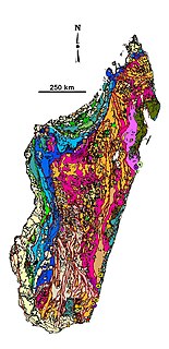
The geology of Madagascar comprises a variety of rocks of Precambrian age which make up the larger part of the east and centre of the island. They are intruded by basalts and rhyolites of Mesozoic to Cenozoic age. In contrast, the western part of the island is formed from sedimentary rocks of Carboniferous to Quaternary age. Archean rocks occur from the northeast portion of the island down to the south in the Ranotsara shear zone. Rocks in the northern portion of Madagascar are greenstone belts, from the Archean or Paleoproterozoic age.
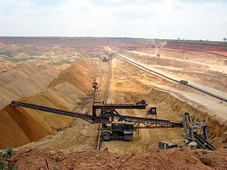
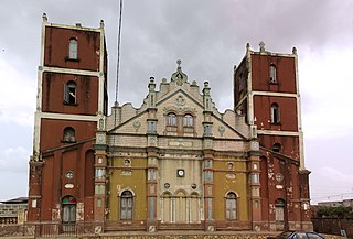
The mining industry of Togo is centred mainly around the extraction of phosphate, ranking it 19th in world production. Other minerals extracted are diamond, gold, and limestone. More minerals identified but yet to be brought into production mode are manganese, bauxite, gypsum, iron ore, marble, rutile, and zinc. The mineral sector contributes 2.8% to the country's gross domestic product (GDP).

The geology of the Republic of the Congo, also known as Congo-Brazzaville, to differentiate from the Democratic Republic of the Congo, formerly Zaire, includes extensive igneous and metamorphic basement rock, some up to two billion years old and sedimentary rocks formed within the past 250 million years. Much of the country's geology is hidden by sediments formed in the past 2.5 million years of the Quaternary.

The geology of the Democratic Republic of the Congo, commonly abbreviated as DRC, also known as Congo-Kinshasa and formerly as Zaire and Belgian Congo, is extremely old, on the order of several billion years for many rocks. The country spans the Congo Craton: a stable section of ancient continental crust, deformed and influenced by several different mountain building orogeny events, sedimentation, volcanism and the geologically recent effects of the East Africa Rift System in the east. The country's complicated tectonic past have yielded large deposits of gold, diamonds, coltan and other valuable minerals.
The geology of Niger comprises very ancient igneous and metamorphic crystalline basement rocks in the west, more than 2.2 billion years old formed in the late Archean and Proterozoic eons of the Precambrian. The Volta Basin, Air Massif and the Iullemeden Basin began to form in the Neoproterozoic and Paleozoic, along with numerous ring complexes, as the region experienced events such as glaciation and the Pan-African orogeny. Today, Niger has extensive mineral resources due to complex mineralization and laterite weathering including uranium, molybdenum, iron, coal, silver, nickel, cobalt and other resources.

The geology of Tanzania began to form in the Precambrian, in the Archean and Proterozoic eons, in some cases more than 2.5 billion years ago. Igneous and metamorphic crystalline basement rock forms the Archean Tanzania Craton, which is surrounded by the Proterozoic Ubendian belt, Mozambique Belt and Karagwe-Ankole Belt. The region experienced downwarping of the crust during the Paleozoic and Mesozoic, as the massive Karoo Supergroup deposited. Within the past 100 million years, Tanzania has experienced marine sedimentary rock deposition along the coast and rift formation inland, which has produced large rift lakes. Tanzania has extensive, but poorly explored and exploited natural resources, including coal, gold, diamonds, graphite and clays.
The geology of Nigeria formed beginning in the Archean and Proterozoic eons of the Precambrian. The country forms the Nigerian Province and more than half of its surface is igneous and metamorphic crystalline basement rock from the Precambrian. Between 2.9 billion and 500 million years ago, Nigeria was affected by three major orogeny mountain-building events and related igneous intrusions. Following the Pan-African orogeny, in the Cambrian at the time that multi-cellular life proliferated, Nigeria began to experience regional sedimentation and witnessed new igneous intrusions. By the Cretaceous period of the late Mesozoic, massive sedimentation was underway in different basins, due to a large marine transgression. By the Eocene, in the Cenozoic, the region returned to terrestrial conditions.
The geology of Kazakhstan includes extensive basement rocks from the Precambrian and widespread Paleozoic rocks, as well as sediments formed in rift basins during the Mesozoic.