Geology of Zimbabwe

Last updated
Map of the Zimbabwe and Kaapvaal Cratons Southern African Cratons.svg
Map of the Zimbabwe and Kaapvaal Cratons
SW end of the 550 km long Great Dyke of Zimbabwe from ISS, 2010. Great Dyke of Zimbabwe ISS.JPG
SW end of the 550 km long Great Dyke of Zimbabwe from ISS, 2010.
Brachiosaurus femur and Geologist Metrinah Ruzvidzo, 2005 Brachiosaurus femur & Geologist.jpg
Brachiosaurus femur and Geologist Metrinah Ruzvidzo, 2005

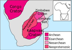
The geology of Zimbabwe in southern Africa is centered on the Zimbabwe Craton, a core of Archean basement composed in the main of granitoids, schist and gneisses. It also incorporates greenstone belts comprising mafic, ultramafic and felsic volcanics which are associated with epiclastic sediments and iron formations. The craton is overlain in the north, northwest and east by Proterozoic and Phanerozoic sedimentary basins whilst to the northwest are the rocks of the Magondi Supergroup. [1] Northwards is the Zambezi Belt and to the east the Mozambique Belt. South of the Zimbabwe Craton is the Kaapvaal Craton separated from it by the Limpopo Mobile Belt, a zone of deformation and metamorphism reflecting geological events from Archean to Mesoproterozoic times. The Zimbabwe Craton is intruded by an elongate ultramafic/mafic igneous complex known as the Great Dyke which runs for more than 500 km along a SSW/NNE oriented graben. It consists of peridotites, pyroxenites, norites and bands of chromitite. [2]

Contents

Stratigraphy

Precambrian

The oldest supracrustal rocks are the Sebakwian Group (3.5 Ga) exposed around Shurugwi and Mashava, and northwest of Gweru, within the central craton. This group consist of metavolcanic rocks, including komatiite and basalt, banded iron formation, and clastic metasedimentary rocks. The Sebakwian Group is succeeded by the Bulawayan Group, further differentiated by the Lower Greenstones (2.9 Ga) and Upper Greenstones (2.7 Ga). The Lower Greenstones include felsic volcanic and volcaniclastic rocks, komatiites, and komatiitic basalts with interbedded iron-formations and polymict clastic sediments. Overlying the Bulawayan Group is the Shamvaian Group (2.7 Ga), and it is these two groups which constitute the main greenstone belts. The tonalitic Sesombi Suite and granitic Chilimanzi Suite granitoids intruded the Upper Greenstones and Shamvaian Group between 2.7 Ga to 2.6 Ga. The last major Archaen event was the intrusion of the Great Dyke (2.5 Ga). [3] [4]

By 1982, 123 mines had produced 155 tonnes of gold from the stratabound iron-formations of the Sebakwian, and Lower and Upper Greenstones. Of these mines, 31 had produced more than 311 kg, with the Wanderer Mine near Shurugwi producing the most at 36 tonnes. Non-stratabound gold production included 128 tonnes from the Que Que Ultramafic Complex within the Mashaba Ultramafic Suite of the Upper Greenstones, while the Upper Greenstone Basaltic and Bimodal Units had produced 400 and 161 tonnes respectively. Granitoid host rocks had produced a total of 132 tonnes of gold, and include the Rhodesdale Batholith at 53 tonnes, the Sesombi Suite at 36 tonnes, and the Penhalonga quartz diorite at 10 tonnes. [3]

Economic geology

Zimbabwe's mineral resources include, amongst others, coal, chromium ore, nickel, copper, iron ore, vanadium, tin, platinum group metals (such as palladium) and diamonds. Globally it is a significant producer of lithium, chrysotile asbestos and vermiculite. Gold, platinum group metals and chromium are Zimbabwe's key mineral resources. The Great Dyke provides most of Zimbabwe's chromium reserves. Zimbabwe experienced a decline in the mining of many minerals in the period to 2008 including the closure of several gold mines. However, diamond production increased making the country Africa's seventh largest producer by 2008. [5]

The country has considerable coal reserves which are used in power generation. Its coal-bed methane field, the largest in southern Africa has not yet been exploited to the full. [6]

See also

Related Research Articles

Greenstone belt Zone of variably metamorphosed rocks occurring in Archaean and Proterozoic cratons

Greenstone belts are zones of variably metamorphosed mafic to ultramafic volcanic sequences with associated sedimentary rocks that occur within Archaean and Proterozoic cratons between granite and gneiss bodies.

Komatiite Ultramafic mantle-derived volcanic rock

Komatiite is a type of ultramafic mantle-derived volcanic rock defined as having crystallised from a lava of at least 18 wt% MgO. Komatiites have low silicon, potassium and aluminium, and high to extremely high magnesium content. Komatiite was named for its type locality along the Komati River in South Africa, and frequently displays spinifex texture composed of large dendritic plates of olivine and pyroxene.

The Yilgarn Craton is a large craton that constitutes the bulk of the Western Australian land mass. It is bounded by a mixture of sedimentary basins and Proterozoic fold and thrust belts. Zircon grains in the Jack Hills, Narryer Terrane have been dated at ~4.27 Ga, with one detrital zircon dated as old as 4.4 Ga.

The Gawler Craton covers approximately 440,000 square kilometres of central South Australia. Its Precambrian crystalline basement crustal block was cratonised ca. 1550–1450 Ma. Prior to 1550 Ma the craton comprised a number of active Proterozoic orogenic belts extending back in time to at least 2450 Ma.

Kaapvaal Craton Archaean craton, possibly part of the Vaalbara supercontinent

The Kaapvaal Craton, along with the Pilbara Craton of Western Australia, are the only remaining areas of pristine 3.6–2.5 Ga crust on Earth. Similarities of rock records from both these cratons, especially of the overlying late Archean sequences, suggest that they were once part of the Vaalbara supercontinent.

Zimbabwe Craton Area in Southern Africa of ancient continental crust

The Zimbabwe Craton is an area in Southern Africa of ancient continental crust, being a part of the ancient continent of Western Gondwana, with rocks dating back to the early Archean Eon, possibly as early as 3.46 billion years ago (Ga.). The craton is named after the country of Zimbabwe where the majority of the craton is. The rocks of the Zimbabwe Craton are separated from the rocks of the Kaapvaal Craton to the southeast by the 250 kilometres (160 mi) wide Limpopo Belt of granulite facies tectonites. The Limpopo belt formed contemporaneously with the Zimbabwe and Kaapvaal cratons, but remained geologically active until much later. It was only in the late Archean, ca. 2.8-2.5 Ga., that the two cratons were stabilized together and that high-grade metamorphism ceased in the Limpopo Belt. North of the Zimbabwe Craton is the Zambezi Belt.

Barberton Greenstone Belt Ancient granite-greenstone terrane on the eastern edge of the Kaapvaal craton in South Africa

The Barberton Greenstone Belt, also known as the Makhonjwa Mountains, is situated on the eastern edge of Kaapvaal Craton in South Africa. It is known for its gold mineralisation and for its komatiites, an unusual type of ultramafic volcanic rock named after the Komati River that flows through the belt. Some of the oldest exposed rocks on Earth are located in the Barberton Greenstone Belt of the Swaziland–Barberton areas and these contain some of the oldest traces of life on Earth. Only the rocks found in the Isua Greenstone Belt of Western Greenland are older.

Churchill Craton Northwest section of the Canadian Shield from southern Saskatchewan and Alberta to northern Nunavut

The Churchill Craton is the northwest section of the Canadian Shield and stretches from southern Saskatchewan and Alberta to northern Nunavut. It has a very complex geological history punctuated by at least seven distinct regional tectonometamorphic intervals, including many discrete accretionary magmatic events. The Western Churchill province is the part of the Churchill Craton that is exposed north and west of the Hudson Bay. The Archean Western Churchill province contributes to the complicated and protracted tectonic history of the craton and marks a major change in the behaviour of the Churchill Craton with many remnants of Archean supracrustal and granitoid rocks.

The Abitibi greenstone belt is a 2,800-to-2,600-million-year-old greenstone belt that spans across the Ontario–Quebec border in Canada. It is mostly made of volcanic rocks, but also includes ultramafic rocks, mafic intrusions, granitoid rocks, and early and middle Precambrian sediments.

Circum-Superior Belt

The Circum-Superior Belt is a widespread Paleoproterozoic large igneous province in the Canadian Shield of Northern, Western and Eastern Canada. It extends more than 3,400 km (2,100 mi) from northeastern Manitoba through northwestern Ontario, southern Nunavut to northern Quebec. Igneous rocks of the Circum-Superior Belt are mafic-ultramafic in composition, deposited in the Labrador Trough near Ungava Bay, the Cape Smith Belt near the southern shore of Hudson Strait and along the eastern shore of Hudson Bay in its northern portion; the Thompson and Fox River belts in the northwest and the Marquette Range Supergroup in its southern portion. The Circum Superior Belt also hosts a rare example of Proterozoic Komatiite, in the Winnipegosis komatiite belt.

Tectonic evolution of the Barberton greenstone belt

The Barberton greenstone belt (BGB) is located in the Kapvaal craton of southeastern Africa. It characterizes one of the most well-preserved and oldest pieces of continental crust today by containing rocks in the Barberton Granite Greenstone Terrain (3.55–3.22 Ga). The BGB is a small, cusp-shaped succession of volcanic and sedimentary rocks, surrounded on all sides by granitoid plutons which range in age from >3547 to <3225 Ma. It is commonly known as the type locality of the ultramafic, extrusive volcanic rock, the komatiite. Greenstone belts are geologic regions generally composed of mafic to ultramafic volcanic sequences that have undergone metamorphism. These belts are associated with sedimentary rocks that occur within Archean and Proterozoic cratons between granitic bodies. Their name is derived from the green hue that comes from the metamorphic minerals associated with the mafic rocks. These regions are theorized to have formed at ancient oceanic spreading centers and island arcs. In simple terms, greenstone belts are described as metamorphosed volcanic belts. Being one of the few most well-preserved Archean portions of the crust, with Archean felsic volcanic rocks, the BGB is well studied. It provides present geologic evidence of Earth during the Archean (pre-3.0 Ga). Despite the BGB being a well studied area, its tectonic evolution has been the cause of much debate.

Eastern Pilbara Craton

The Eastern Pilbara Craton is the eastern portion of the Pilbara Craton located in Western Australia. This region contains variably metamorphosed mafic and ultramafic greenstone belt rocks, intrusive granitic dome structures, and volcanic sedimentary rocks. These greenstone belts worldwide are thought to be the remnants of ancient volcanic belts, and are subject to much debate in today's scientific community. Areas such as Isua and Barberton which have similar lithologies and ages as Pilbara have been argued to be subduction accretion arcs, while others suggest that they are the result of vertical tectonics. This debate is crucial to investigating when/how plate tectonics began on Earth. The Pilbara Craton along with the Kaapvaal Craton are the only remaining areas of the Earth with pristine 3.6–2.5 Ga crust. The extremely old and rare nature of this crustal region makes it a valuable resource in the understanding of the evolution of the Archean Earth.

Eoarchean geology

Eoarchean geology is the study of the oldest preserved crustal fragments of Earth during the Eoarchean era from 4 to 3.6 billion years ago. Major well-preserved rock units dated Eoarchean are known from three localities, the Isua Greenstone Belt in Southwest Greenland, the Acasta Gneiss in the Slave Craton in Canada, and the Nuvvuagittuq Greenstone Belt in the eastern coast of Hudson Bay in Quebec. From the dating of rocks in these three regions scientists suggest that plate tectonics could go back as early as Eoarchean.

Geology of Ghana

The geology of Ghana is primarily very ancient crystalline basement rock, volcanic belts and sedimentary basins, affected by periods of igneous activity and two major orogeny mountain building events. Aside from modern sediments and some rocks formed within the past 541 million years of the Phanerozoic Eon, along the coast, many of the rocks in Ghana formed close to one billion years ago or older leading to five different types of gold deposit formation, which gave the region its former name Gold Coast.

Geology of the Democratic Republic of the Congo

The geology of the Democratic Republic of the Congo is extremely old, on the order of several billion years for many rocks. The country spans the Congo Craton: a stable section of ancient continental crust, deformed and influenced by several different mountain building orogeny events, sedimentation, volcanism and the geologically recent effects of the East Africa Rift System in the east. The country's complicated tectonic past have yielded large deposits of gold, diamonds, coltan and other valuable minerals.

Geology of Sweden

The geology of Sweden is the regional study of rocks, minerals, tectonics, natural resources and groundwater in the country. The oldest rocks in Sweden date to more than 2.5 billion years ago in the Precambrian. Complex orogeny mountain building events and other tectonic occurrences built up extensive metamorphic crystalline basement rock that often contains valuable metal deposits throughout much of the country. Metamorphism continued into the Paleozoic after the Snowball Earth glaciation as the continent Baltica collided with an island arc and then the continent Laurentia. Sedimentary rocks are most common in southern Sweden with thick sequences from the last 250 million years underlying Malmö and older marine sedimentary rocks forming the surface of Gotland.

Archean felsic volcanic rocks Felsic volcanic rocks formed in the Archean Eon

Archean felsic volcanic rocks are felsic volcanic rocks that were formed in the Archean Eon. The term "felsic" means that the rocks have silica content of 62–78%. Given that the Earth formed at ~4.5 billion year ago, Archean felsic volcanic rocks provide clues on the Earth's first volcanic activities on the Earth's surface started 500 million years after the Earth's formation.

The geology of Nunavut began to form nearly three billion years ago in the Archean and the territory preserves some of the world's oldest rock units.

Eastern Block of the North China Craton

The Eastern Block of the North China Craton is one of the Earth's oldest pieces of continent. It is separated from the Western Block by the Trans-North China Orogen. It is situated in northeastern China and North Korea. The Block contains rock exposures older than 2.5 billion years. It serves as an ideal place to study how the crust was formed in the past and the related tectonic settings.

Dharwar Craton Part of the Indian Shield in south India

The Dharwar Craton is an Archean continental crust craton formed between 3.6-2.5 billion years ago (Ga), which is located in southern India and considered as the oldest part of the Indian peninsula.

References

  1. Treloar, Peter J. (1988). "The geological evolution of the Magondi Mobile Belt, Zimbabwe". Precambrian Research. 38 (1): 55–73. doi:10.1016/0301-9268(88)90093-9.
  2. "Zimbabwe, geology Extractive Industries Source Book". Archived from the original on 2013-03-02. Retrieved 2013-04-20.
  3. 1 2 Foster, R.P; Wilson, J.F. (1984). Foster, R.P. (ed.). Geological setting of Archaen gold deposits in Zimbabwe, in Gold '82: The Geology, Geochemistry and Genesis of Gold Deposits. Rotterdam: Geological Society of Zimbabwe, A.A. Balkema. pp. 524–543. ISBN   906191504X.
  4. Mann, A.G. (1984). Foster, R.P. (ed.). Gold mines in Archaen granitic rocks in Zimbabwe, in Gold '82: The Geology, Geochemistry and Genesis of Gold Deposits. Rotterdam: Geological Society of Zimbabwe, A.A. Balkema. pp. 572–573. ISBN   906191504X.
  5. "Zimbabwe, mining Extractive Industries Source Book". Archived from the original on 2013-03-02. Retrieved 2013-04-20.
  6. Zimbabwe, oil and gas Extractive Industries Source Book