Related Research Articles

The Réunion hotspot is a volcanic hotspot which currently lies under the island of Réunion in the Indian Ocean. The Chagos-Laccadive Ridge and the southern part of the Mascarene Plateau are volcanic traces of the Réunion hotspot.

The Mascarene Plateau is a submarine plateau in the Indian Ocean, north and east of Madagascar. The plateau extends approximately 2,000 km (1,200 mi), from Seychelles in the north to Réunion in the south. The plateau covers an area of over 115,000 km2 (44,000 sq mi) of shallow water, with depths ranging from 8–150 m (30–490 ft), plunging to 4,000 m (13,000 ft) to the abyssal plain at its edges.

Volcanic activity is a major part of the geology of Canada and is characterized by many types of volcanic landform, including lava flows, volcanic plateaus, lava domes, cinder cones, stratovolcanoes, shield volcanoes, submarine volcanoes, calderas, diatremes, and maars, along with less common volcanic forms such as tuyas and subglacial mounds.

The geology of the Pacific Northwest includes the composition, structure, physical properties and the processes that shape the Pacific Northwest region of North America. The region is part of the Ring of Fire: the subduction of the Pacific and Farallon Plates under the North American Plate is responsible for many of the area's scenic features as well as some of its hazards, such as volcanoes, earthquakes, and landslides.
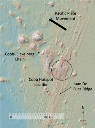
The Cobb hotspot is a marine volcanic hotspot at, which is 460 km (290 mi) west of Oregon and Washington, North America, in the Pacific Ocean. Over geologic time, the Earth's surface has migrated with respect to the hotspot through plate tectonics, creating the Cobb–Eickelberg Seamount chain. The hotspot is currently collocated with the Juan de Fuca Ridge.

The volcanology of Eastern Canada includes the hundreds of volcanic areas and extensive lava formations in Eastern Canada. The region's different volcano and lava types originate from different tectonic settings and types of volcanic eruptions, ranging from passive lava eruptions to violent explosive eruptions. Eastern Canada has very large volumes of magmatic rock called large igneous provinces. They are represented by deep-level plumbing systems consisting of giant dike swarms, sill provinces and layered intrusions. The most capable large igneous provinces in Eastern Canada are Archean age greenstone belts containing a rare volcanic rock called komatiite.

Volcanism of Northern Canada has produced hundreds of volcanic areas and extensive lava formations across Northern Canada. The region's different volcano and lava types originate from different tectonic settings and types of volcanic eruptions, ranging from passive lava eruptions to violent explosive eruptions. Northern Canada has a record of very large volumes of magmatic rock called large igneous provinces. They are represented by deep-level plumbing systems consisting of giant dike swarms, sill provinces and layered intrusions.

Noronha hotspot is a hypothesized hotspot in the Atlantic Ocean. It has been proposed as the candidate source for volcanism in the Fernando de Noronha archipelago of Brazil, as well as of other volcanoes also in Brazil and even the Bahamas and the Central Atlantic Magmatic Province.
The Comoros island chain in the Mozambique Channel is the result of the rifting of Madagascar away from Africa as well as "hotspot" mantle plume activity. The region is also impact by seismicity and deformation associated with the East African Rift system and the Comoros region is one of the best places in the world to study rift-hotspot interactions. The islands remain volcanically active.

As part of the Comoro Islands chain in the Mozambique Channel, the geology of Mayotte is virtually the same as the geology of the Comoros, the rest of the island chain which is independent of France. The island resulted from the rifting of Madagascar away from Africa as well as "hotspot" mantle plume activity, and is also impacted by seismicity and deformation associated with the East African Rift. However, because Mayotte is a part of France its geology is significantly more researched than that of other islands in the chain.
São Tomé and Príncipe both formed within the past 30 million years due to volcanic activity in deep water along the Cameroon line. Long-running interactions with seawater and different eruption periods have generated a wide variety of different igneous and volcanic rocks on the islands with complex mineral assemblages.
Réunion is a mafic island formed as a result of the Réunion hotspot in the Indian Ocean, the same hotspot that produced the massive basalt flows of the Deccan Traps, when it was beneath India more than 66 million years ago.

Madeira began to form more than 100 million years ago in the Early Cretaceous, although most of the island has formed in the last 66 million years of the Cenozoic, particularly in the Miocene and Pliocene. The island is an example of hotspot volcanism, with mainly mafic volcanic and igneous rocks, together with smaller deposits of limestone, lignite and other sediments that record its long-running uplift.

The geology of the Democratic Republic of the Congo is extremely old, on the order of several billion years for many rocks. The country spans the Congo Craton: a stable section of ancient continental crust, deformed and influenced by several different mountain building orogeny events, sedimentation, volcanism and the geologically recent effects of the East Africa Rift System in the east. The country's complicated tectonic past have yielded large deposits of gold, diamonds, coltan and other valuable minerals.
The geology of Cameroon is almost universally Precambrian metamorphic and igneous basement rock, formed in the Archean as part of the Congo Craton and the Central African Mobile Zone and covered in laterite, recent sediments and soils. Some parts of the country have sequences of sedimentary rocks from the Paleozoic, Mesozoic and Cenozoic as well as volcanic rock produced by the 1600 kilometer Cameroon Volcanic Line, which includes the still-active Mount Cameroon. The country is notable for gold, diamonds and some onshore and offshore oil and gas.
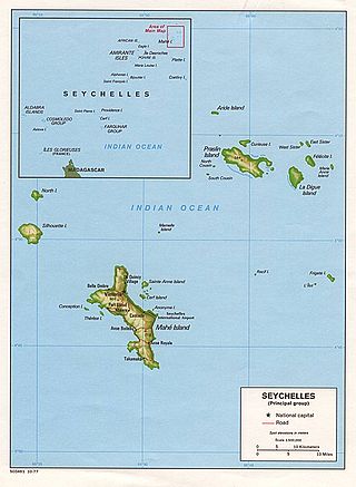
The geology of Seychelles is an example of a felsic granite microcontinent that broke off from the supercontinent Gondwana within the past 145 million years and become isolated in the Indian Ocean. The islands are primarily granite rock, with some sequences of sedimentary rocks formed during rift basin periods or times when the islands were submerged in shallow water.
The geology of Lesotho is built on ancient crystalline basement rock up to 3.6 billion years old, belonging to the Kaapvaal Craton, a section of stable primordial crust. Most of the rocks in the country are sedimentary or volcanic units, belonging to the Karoo Supergroup. The country is notable for large fossil deposits and intense erosion due to high rainfall and a rare case of southern African glaciation during the last ice age. Lesotho has extensive diamonds and other natural resources and has the highest concentration of kimberlite pipes anywhere in the world.

The geology of Tanzania began to form in the Precambrian, in the Archean and Proterozoic eons, in some cases more than 2.5 billion years ago. Igneous and metamorphic crystalline basement rock forms the Archean Tanzania Craton, which is surrounded by the Proterozoic Ubendian belt, Mozambique Belt and Karagwe-Ankole Belt. The region experienced downwarping of the crust during the Paleozoic and Mesozoic, as the massive Karoo Supergroup deposited. Within the past 100 million years, Tanzania has experienced marine sedimentary rock deposition along the coast and rift formation inland, which has produced large rift lakes. Tanzania has extensive, but poorly explored and exploited natural resources, including coal, gold, diamonds, graphite and clays.

The geology of Senegal formed beginning more than two billion years ago. The Archean greenschist Birimian rocks common throughout West Africa are the oldest in the country, intruded by Proterozoic granites. Basins formed in the interior during the Paleozoic and filled with sedimentary rocks, including tillite from a glaciation. With the rifting apart of the supercontinent Pangaea in the Mesozoic, the large Senegal Basin filled with thick sequences of marine and terrestrial sediments. Sea levels declined in the Eocene forming large phosphate deposits. Senegal is blanketed in thick layers of terrestrial sediments formed in the Quaternary. The country has extensive natural resources, including gold, diamonds, and iron.

The geology of Sudan formed primarily in the Precambrian, as igneous and metamorphic crystalline basement rock. Ancient terranes and inliers were intruded with granites, granitoids as well as volcanic rocks. Units of all types were deformed, reactivated, intruded and metamorphosed during the Proterozoic Pan-African orogeny. Dramatic sheet flow erosion prevented almost any sedimentary rocks from forming during the Paleozoic and Mesozoic. From the Mesozoic into the Cenozoic the formation of the Red Sea depression and complex faulting led to massive sediment deposition in some locations and regional volcanism. Sudan has petroleum, chromite, salt, gold, limestone and other natural resources.
References
- ↑ Schlüter, Thomas (2008). Geological Atlas of Africa. Springer. pp. 170–171.
- 1 2 Schlüter 2008, p. 170.
- ↑ Boyd, Andrew. "Hydrogeology of Mauritius".