Geology of Ascension Island

Last updated

The geology of Ascension Island is the geologically young, exposed part of a large volcano, 80 kilometers west of the Mid-Atlantic Ridge. The island formed within the last six to seven million years and is primarily mafic rock with some felsic rock. [1] [2]

Contents

Physical map of Ascension Island Ile de l'ascension routes.svg
Physical map of Ascension Island

Origins & Petrology

Geologists debate the exact origins of the island and some have proposed that Ascension Island may overlie a diverted shallow mantle plume. Alternately, the island may have originated from anomalously enriched magma, originally at the Mid-Atlantic Ridge, but now situated to the west of it.

The petrology of Ascension is unusual. Compared to most other volcanic islands, which only have a few mafic and felsic endmembers such as basalt or rhyolite, Ascension has a full-range from some of the most mafic to most felsic. This includes basalt, hawaiite, mugearite, benmoreite, trachyte and rhyolite.

Potassium-argon dating indicates that the oldest rocks exposed above the water are one million year old rhyolites. [3] Geologists have divided the island's mafic and felsic rocks into different named sequences and sub-divided mafic rocks based on their ratio of zirconium and niobium.

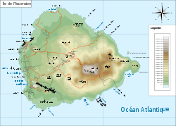
Sister's Peak Region

The Sister's Peak region in northwest Ascension has intermediate mafic lava flows, scoria cones and mafic ash fall deposits near Long Beach. The flows formed approximately 829,000 years ago and range between basalt, hawaiite and mugearite compositions. Benmoreite flows outcrop near Long Bay and west of Lady Hill. Additionally, benmoreite cinder cones are found near Broken Tooth and Hollow Tooth. The two youngest eruptions on the Island occurred in the Sisters Peak Region around 500 years ago. [4]

Eastern Felsic Complex

The Eastern Felsic Complex (EFC), in northeastern Ascension has a ring-shape geometry with felsic flows and pyroclastic deposits. Rocks in the EFC constitute trachyte, rhyolite and formations such as lava domes and thick flows. Pyroclastics exhibit a blend of ash and pumice. These rocks formed approximately 517,000 years ago.

Letterbox area

The Devil's Inkpot lava flows formed from a fissure around the same time as the Sister's Peak region 829,000 years ago. Benmoreite scoria cones record evidence of mafic volcanism, although older rhyolite and trachyte flows, domes and pyroclastic deposits point to felsic eruptions as well.

Central Felsic Complex

The Central Felsic Complex (CFC), centers on Green Mountain and Middleton Ridge and is older than the Eastern Felsic Complex. Here, ash is typically welded together and breccia is laden with rhyolite and obsidian fragments. Middleton Ridge formed more than one million years ago and is accompanied trachyte and rhyolite flows. By comparison, Green Mountain formed as recently as 395,000 years ago with trachyte flows and pyroclastics grouped around a mafic scoria cone.

The scoria hosts pluton xenoliths.

Wideawakes

The 758,000 year old intermediate bentmoreite lava flows of southwest Ascension are interspersed with scoria cones and periodically mafic ash falls.

South Coast

The South Coast of Ascension has old, highly mafic lava flows. Bentmoreite flows are most common, although a basalt flow outcrops in Crystal Bay, a mafic scoria cone forms Ragged Hill and trachyte outcrops immediately south of the hill. [1]

Related Research Articles

<span class="mw-page-title-main">Volcano</span> Rupture in the crust of a planet that allows lava, ash, and gases to escape from below the surface

A volcano is a rupture in the crust of a planetary-mass object, such as Earth, that allows hot lava, volcanic ash, and gases to escape from a magma chamber below the surface.

<span class="mw-page-title-main">Tuff</span> Rock consolidated from volcanic ash

Tuff is a type of rock made of volcanic ash ejected from a vent during a volcanic eruption. Following ejection and deposition, the ash is lithified into a solid rock. Rock that contains greater than 75% ash is considered tuff, while rock containing 25% to 75% ash is described as tuffaceous. Tuff composed of sandy volcanic material can be referred to as volcanic sandstone.

<span class="mw-page-title-main">Rhyolite</span> Igneous, volcanic rock, of felsic (silica-rich) composition

Rhyolite is the most silica-rich of volcanic rocks. It is generally glassy or fine-grained (aphanitic) in texture, but may be porphyritic, containing larger mineral crystals (phenocrysts) in an otherwise fine-grained groundmass. The mineral assemblage is predominantly quartz, sanidine, and plagioclase. It is the extrusive equivalent to granite.

<span class="mw-page-title-main">Volcanic cone</span> Landform of ejecta from a volcanic vent piled up in a conical shape

Volcanic cones are among the simplest volcanic landforms. They are built by ejecta from a volcanic vent, piling up around the vent in the shape of a cone with a central crater. Volcanic cones are of different types, depending upon the nature and size of the fragments ejected during the eruption. Types of volcanic cones include stratocones, spatter cones, tuff cones, and cinder cones.

<span class="mw-page-title-main">Extrusive rock</span> Mode of igneous volcanic rock formation

Extrusive rock refers to the mode of igneous volcanic rock formation in which hot magma from inside the Earth flows out (extrudes) onto the surface as lava or explodes violently into the atmosphere to fall back as pyroclastics or tuff. In contrast, intrusive rock refers to rocks formed by magma which cools below the surface.

<span class="mw-page-title-main">Anahim Volcanic Belt</span> Chain of volcanoes and related magmatic features in British Columbia, Canada

The Anahim Volcanic Belt (AVB) is a west–east trending chain of volcanoes and related magmatic features in British Columbia, Canada. It extends from Athlone Island on the Central Coast, running eastward through the strongly uplifted and deeply dissected Coast Mountains to near the community of Nazko on the Interior Plateau. The AVB is delineated as three west-to-east segments that differ in age and structure. A wide variety of igneous rocks with differing compositions occur throughout these segments, comprising landforms such as volcanic cones, volcanic plugs, lava domes, shield volcanoes and intrusions.

<span class="mw-page-title-main">Itcha Range</span> Mountain range in British Columbia, Canada

The Itcha Range, also known as the Itchas, is a small isolated mountain range in the West-Central Interior of British Columbia, Canada. It is located 40 km (25 mi) northeast of the community of Anahim Lake. With a maximum elevation of 2,375 m (7,792 ft), it is the lowest of three mountain ranges on the Chilcotin Plateau extending east from the Coast Mountains. Two mountains are named in the Itcha Range; Mount Downton and Itcha Mountain. A large provincial park surrounds the Itcha Range and other features in its vicinity. More than 15 animal species are known to exist in the Itcha Range area, as well as a grassland community that is limited only to this location of British Columbia. The Itcha Range is within territory which has been occupied by aboriginal peoples for millennia. This area has a relatively dry environment compared to the Coast Mountains in the west.

<span class="mw-page-title-main">Level Mountain</span> Volcanic complex in British Columbia, Canada

Level Mountain is a large volcanic complex in the Northern Interior of British Columbia, Canada. It is located 50 kilometres north-northwest of Telegraph Creek and 60 kilometres west of Dease Lake on the Nahlin Plateau. With a maximum elevation of 2,164 metres, it is the second-highest of four large complexes in an extensive north–south trending volcanic region. Much of the mountain is gently-sloping; when measured from its base, Level Mountain is about 1,100 metres tall, slightly taller than its neighbour to the northwest, Heart Peaks. The lower, broader half of Level Mountain consists of a shield-like structure while its upper half has a more steep, jagged profile. Its broad summit is dominated by the Level Mountain Range, a small mountain range with prominent peaks cut by deep valleys. These valleys serve as a radial drainage for several small streams that flow from the mountain. Meszah Peak is the only named peak in the Level Mountain Range.

The Anahim hotspot is a hypothesized hotspot in the Central Interior of British Columbia, Canada. It has been proposed as the candidate source for volcanism in the Anahim Volcanic Belt, a 300 kilometres long chain of volcanoes and other magmatic features that have undergone erosion. This chain extends from the community of Bella Bella in the west to near the small city of Quesnel in the east. While most volcanoes are created by geological activity at tectonic plate boundaries, the Anahim hotspot is located hundreds of kilometres away from the nearest plate boundary.

<span class="mw-page-title-main">Cinder cone</span> Steep hill of pyroclastic fragments around a volcanic vent

A cinder cone is a steep conical hill of loose pyroclastic fragments, such as volcanic clinkers, volcanic ash, or scoria that has been built around a volcanic vent. The pyroclastic fragments are formed by explosive eruptions or lava fountains from a single, typically cylindrical, vent. As the gas-charged lava is blown violently into the air, it breaks into small fragments that solidify and fall as either cinders, clinkers, or scoria around the vent to form a cone that often is symmetrical; with slopes between 30 and 40°; and a nearly circular ground plan. Most cinder cones have a bowl-shaped crater at the summit.

<span class="mw-page-title-main">Mount Edziza volcanic complex</span> Volcanic complex in British Columbia, Canada

The Mount Edziza volcanic complex is a linear group of volcanoes and associated lava flows in northwestern British Columbia, Canada. It is located 40 kilometres southeast of Telegraph Creek and 85 kilometres southwest of Dease Lake on the Tahltan Highland. The complex encompasses a broad, steep-sided lava plateau that extends over an area of 1,000 square kilometres. Its highest summit reaches an altitude of 2,786 metres above sea level, making the MEVC the highest of four large complexes in an extensive north–south trending volcanic region. An ice cap obscures the highest summit which is characterized by several outlet glaciers stretching out to lower altitudes.

<span class="mw-page-title-main">Lava</span> Molten rock expelled by a volcano during an eruption

Lava is molten or partially molten rock (magma) that has been expelled from the interior of a terrestrial planet or a moon onto its surface. Lava may be erupted at a volcano or through a fracture in the crust, on land or underwater, usually at temperatures from 800 to 1,200 °C. The volcanic rock resulting from subsequent cooling is also often called lava.

<span class="mw-page-title-main">Benmoreite</span> Volcanic rock type

Benmoreite is a volcanic rock of intermediate composition. It is a silica-undersaturated sodium-rich variety of trachyandesite and belongs to the alkaline suite of igneous rocks.

<span class="mw-page-title-main">Canadian Cascade Arc</span> Canadian segment of the North American Cascade Volcanic Arc

The Canadian Cascade Arc, also called the Canadian Cascades, is the Canadian segment of the North American Cascade Volcanic Arc. Located entirely within the Canadian province of British Columbia, it extends from the Cascade Mountains in the south to the Coast Mountains in the north. Specifically, the southern end of the Canadian Cascades begin at the Canada–United States border. However, the specific boundaries of the northern end are not precisely known and the geology in this part of the volcanic arc is poorly understood. It is widely accepted by geologists that the Canadian Cascade Arc extends through the Pacific Ranges of the Coast Mountains. However, others have expressed concern that the volcanic arc possibly extends further north into the Kitimat Ranges, another subdivision of the Coast Mountains, and even as far north as Haida Gwaii.

El Toro volcanic field is part of the Central Volcanic Zone of the Andes in the northern Puna of Argentina. Three of the cones in the volcanic field are located southwest of the town of El Toro and the fourth is found north. Part of a field of monogenetic volcanoes associated with subduction of the Nazca Plate beneath the South American Plate, it is constructed from three main cones and an additional lava flow. The field formed between six and two million years ago.

Cerro Morado is a monogenetic volcanic field, in Argentina. It is part of a group of mafic volcanic centres in the Altiplano-Puna region, which is dominated by silicic rocks such as dacitic - rhyolitic rocks.

The geology of Saint Helena resulted from the long-running volcanic activity of the Saint Helena hotspot. Most of the island was formed beginning 14 million years ago. Volcanism on the island ceased seven million years ago, leading to long-running erosion and the formation of deep, v-shaped valleys along with steep coastal cliffs. Some geochemists have observed significant trace element variations between South Atlantic islands and proposed that deep-ocean sediments may have mixed into the magma which formed Saint Helena.

The alkaline magma series is a chemically distinct range of magma compositions that describes the evolution of an alkaline mafic magma into a more evolved, silica-rich end member.

The Armadillo Formation is a stratigraphic unit of Miocene age in northwestern British Columbia, Canada.

References

  1. 1 2 "The geology of Ascension Island". Ascension Island Volcanology. 2016.
  2. Chamberlain, K. J.; Barclay, J.; Preece, K. J.; Brown, R. J.; Davidson, J. P. (2019). "Lower Crustal Heterogeneity and Fractional Crystallization Control Evolution of Small-volume Magma Batches at Ocean Island Volcanoes (Ascension Island, South Atlantic)". Journal of Petrology. 60 (8): 1489–1522. doi:10.1093/petrology/egz037.
  3. Nielsen & Sibbett (1996). "Geology of ascension Island, South Atlantic Ocean". Geothermics. 25 (4–5): 427–448. doi:10.1016/0375-6505(96)00018-1.
  4. Preece, Katie; Mark, Darren F.; Barclay, Jenni; Cohen, Benjamin E.; Chamberlain, Katy J.; Jowitt, Claire; Vye-Brown, Charlotte; Brown, Richard J.; Hamilton, Scott (2018-12-01). "Bridging the gap: 40Ar/39Ar dating of volcanic eruptions from the 'Age of Discovery'". Geology. 46 (12): 1035–1038. Bibcode:2018Geo....46.1035P. doi:10.1130/G45415.1. ISSN   0091-7613. S2CID   135209923.