Geology of Togo

Last updated
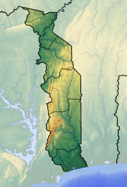
Topography of Togo Togo location map Topographic.png
Topography of Togo

The geology of Togo is largely of gneisses and granitic rocks of Proterozoic age in the central and southern part of the country. These are overlain in the coastal zone by Cretaceous and Cenozoic sediments. The northern part of the country has a basement of Neoproterozoic metamorphic rocks and Paleoproterozoic granite. [1] The south of the country is covered in sedimentary basins, covering 3,300 km.2 of land. The West African Craton is made up of crystalline structures, ranging in age from the Neoarchean to the Paleoproterozoic age. The North-Dapaong zone, which is located in the West African Craton, migmatites, gneisses, amphibolites, granodiorites and granites are commonly found. The Neoproterozoic Volta Basin contains sedimentary formations on the Birrimian bedrocks. These sedimentary formations are divided into two groups: an intra-tillite group and a supra-tillite group. [2]

Economic geology

Togo mines gold, diamonds, and phosphate rock, with the largest of these being phosphate rock. The phosphate rock is found Eocene deposits at the coastal basin. In addition to those easy to exploit locations, there are also hardened Neoproterozoic which have not been exploited. The country is Africa's sixth highest producer of phosphate rock. Diamonds and gold are extracted on the artisanal level, and is Africa's sixth largest gold producer. The diamonds are found in alluvial formations in rivers. Exploration activities unveiled the possibility of mining in the future: bauxite, gypsum, iron ore, manganese, marble, rutile, zinc, uranium, and lithic metals. Togo does not have a petroleum sector. [3] [2] :232

Related Research Articles

The West African Craton (WAC) is one of the five cratons of the Precambrian basement rock of Africa that make up the African Plate, the others being the Kalahari craton, Congo craton, Saharan Metacraton and Tanzania Craton. Cratons themselves are tectonically inactive, but can occur near active margins, with the WAC extending across 14 countries in Western African, coming together in the late Precambrian and early Palaeozoic eras to form the African continent. It consists of two Archean centers juxtaposed against multiple Paleoproterozoic domains made of greenstone belts, sedimentary basins, regional granitoid-tonalite-trondhjemite-granodiorite (TTG) plutons, and large shear zones. The craton is overlain by Neoproterozoic and younger sedimentary basins. The boundaries of the WAC are predominantly defined by a combination of geophysics and surface geology, with additional constraints by the geochemistry of the region. At one time, volcanic action around the rim of the craton may have contributed to a major global warming event.

Geology of Zimbabwe

The geology of Zimbabwe in southern Africa is centered on the Zimbabwe Craton, a core of Archean basement composed in the main of granitoids, schist and gneisses. It also incorporates greenstone belts comprising mafic, ultramafic and felsic volcanics which are associated with epiclastic sediments and iron formations. The craton is overlain in the north, northwest and east by Proterozoic and Phanerozoic sedimentary basins whilst to the northwest are the rocks of the Magondi Supergroup. Northwards is the Zambezi Belt and to the east the Mozambique Belt. South of the Zimbabwe Craton is the Kaapvaal Craton separated from it by the Limpopo Mobile Belt, a zone of deformation and metamorphism reflecting geological events from Archean to Mesoproterozoic times. The Zimbabwe Craton is intruded by an elongate ultramafic/mafic igneous complex known as the Great Dyke which runs for more than 500 km along a SSW/NNE oriented graben. It consists of peridotites, pyroxenites, norites and bands of chromitite.

Huangling Complex

Huangling Complex represents a group of rock units appear in the middle of Yangtze Block in South China, distributed across Yixingshan, Zigui, Huangling and Yichang counties. The group of rock involves nonconformity that sedimentary rocks overlie the metamorphic basement. It is a 73-km long, asymmetrical dome-shaped anticline with axial plane orientating in north-south direction. It has a steeper west flank and a gentler east flank. Basically, there are three tectonic units from the anticline core to the rim, including Archean to Paleoproterozoic metamorphic basement, Neoproterozoic to Jurassic sedimentary rocks and Cretaceous fluvial deposit sedimentary cover. The northern part of the core is mainly tonalite-trondhjemite-gneiss (TTG) and Cretaceous sedimentary rock, it is called the Archean Kongling Complex. The middle of the core is mainly the Neoproterozoic granitoid. The southern part of the core is the Neoproterozoic potassium granite. Two basins are situated on the western and eastern flanks of the core respectively, including the Zigui basin and Dangyang basin. Both basins are synforms while Zigui basin has a larger extent of folding. Yuanan Graben and Jingmen Graben are found within Dangyang Basin area. Huangling Complex is an important area that helps unravel the tectonic history of South China Craton because it has well-exposed layers of rock units from Archean basement rock to Cretaceous sedimentary rock cover due to the erosion of the anticline.

The geology of Central African Republic (CAR) is part of the broader geology of Africa. CAR occupies a swath of ancient rocks, dating back billions of years that record significant aspects of Earth history and yield minerals vital to the country's small economy.

Gabon is situated at the northwestern margin of the Congo Craton—a region of stable, ancient crust—and preserves very ancient rock units across 75% of the country, with overlying sedimentary units from the Cretaceous and other more recent periods.

Geology of the Republic of the Congo

The geology of the Republic of the Congo, also known as Congo-Brazzaville, to differentiate from the Democratic Republic of the Congo, formerly Zaire, includes extensive igneous and metamorphic basement rock, some up to two billion years old and sedimentary rocks formed within the past 250 million years. Much of the country's geology is hidden by sediments formed in the past 2.5 million years of the Quaternary.

The geology of Liberia is largely extremely ancient rock formed between 3.5 billion and 541 million years ago in the Archean and the Neoproterozoic, with some rocks from the past 145 million years near the coast. The country has rich iron resources as well as some diamonds, gold and other minerals in ancient sediment formations weathered to higher concentrations by tropical rainfall.

Geology of Ghana

The geology of Ghana is primarily very ancient crystalline basement rock, volcanic belts and sedimentary basins, affected by periods of igneous activity and two major orogeny mountain building events. Aside from modern sediments and some rocks formed within the past 541 million years of the Phanerozoic Eon, along the coast, many of the rocks in Ghana formed close to one billion years ago or older leading to five different types of gold deposit formation, which gave the region its former name Gold Coast.

Geology of the Democratic Republic of the Congo

The geology of the Democratic Republic of the Congo is extremely old, on the order of several billion years for many rocks. The country spans the Congo Craton: a stable section of ancient continental crust, deformed and influenced by several different mountain building orogeny events, sedimentation, volcanism and the geologically recent effects of the East Africa Rift System in the east. The country's complicated tectonic past have yielded large deposits of gold, diamonds, coltan and other valuable minerals.

The geology of Cameroon is almost universally Precambrian metamorphic and igneous basement rock, formed in the Archean as part of the Congo Craton and the Central African Mobile Zone and covered in laterite, recent sediments and soils. Some parts of the country have sequences of sedimentary rocks from the Paleozoic, Mesozoic and Cenozoic as well as volcanic rock produced by the 1600 kilometer Cameroon Volcanic Line, which includes the still-active Mount Cameroon. The country is notable for gold, diamonds and some onshore and offshore oil and gas.

Geology of Ivory Coast

The geology of Ivory Coast is almost entirely extremely ancient metamorphic and igneous crystalline basement rock between 2.1 and more than 3.5 billion years old, comprising part of the stable continental crust of the West African Craton. Near the surface, these ancient rocks have weathered into sediments and soils 20 to 45 meters thick on average, which holds much of Ivory Coast's groundwater. More recent sedimentary rocks are found along the coast. The country has extensive mineral resources such as gold, diamonds, nickel and bauxite as well as offshore oil and gas.

The geology of Mauritania is built on more than two billion year old Archean crystalline basement rock in the Reguibat Shield of the West African Craton, a section of ancient and stable continental crust. Mobile belts and the large Taoudeni Basin formed and filled with sediments in the connection with the Pan-African orogeny mountain building event 600 million years ago and a subsequent orogeny created the Mauritanide Belt. In the last 251 million years, Mauritania has accumulated additional sedimentary rocks during periods of marine transgression and sea level retreat. The arid country is 50% covered in sand dunes and has extensive mineral resources, although iron plays the most important role in the economy.

The geology of Mozambique is primarily extremely old Precambrian metamorphic and igneous crystalline basement rock, formed in the Archean and Proterozoic, in some cases more than two billion years ago. Mozambique contains greenstone belts and spans the Zimbabwe Craton, a section of ancient stable crust. The region was impacted by major tectonic events, such as the mountain building Irumide orogeny, Pan-African orogeny and the Snowball Earth glaciation. Large basins that formed in the last half-billion years have filled with extensive continental and marine sedimentary rocks, including rocks of the extensive Karoo Supergroup which exist across Southern Africa. In some cases these units are capped by volcanic rocks. As a result of its complex and ancient geology, Mozambique has deposits of iron, coal, gold, mineral sands, bauxite, copper and other natural resources.

Geology of Namibia

The geology of Namibia encompasses rocks of Paleoproterozoic, Mesoproterozoic and Neoproterozoic and Paleozoic to Cenozoic age. About 46% of the countryʼs surface are bedrock exposure, while the remainder is covered by the young overburden sediments of the Kalahari and Namib deserts.

Geology of Tanzania

The geology of Tanzania began to form in the Precambrian, in the Archean and Proterozoic eons, in some cases more than 2.5 billion years ago. Igneous and metamorphic crystalline basement rock forms the Archean Tanzania Craton, which is surrounded by the Proterozoic Ubendian belt, Mozambique Belt and Karagwe-Ankole Belt. The region experienced downwarping of the crust during the Paleozoic and Mesozoic, as the massive Karoo Supergroup deposited. Within the past 100 million years, Tanzania has experienced marine sedimentary rock deposition along the coast and rift formation inland, which has produced large rift lakes. Tanzania has extensive, but poorly explored and exploited natural resources, including coal, gold, diamonds, graphite and clays.

The geology of Uganda extends back to the Archean and Proterozoic eons of the Precambrian, and much of the country is underlain by gneiss, argillite and other metamorphic rocks that are sometimes over 2.5 billion years old. Sedimentary rocks and new igneous and metamorphic units formed throughout the Proterozoic and the region was partially affected by the Pan-African orogeny and Snowball Earth events. Through the Mesozoic and Cenozoic, ancient basement rock has weathered into water-bearing saprolite and the region has experienced periods of volcanism and rift valley formation. The East Africa Rift gives rise to thick, more geologically recent sediment sequences and the country's numerous lakes. Uganda has extensive natural resources, particularly gold.

The geology of Eswatini formed beginning 3.6 billion years ago, in the Archean Eon of the Precambrian. Eswatini is the only country entirely underlain by the Kaapvaal Craton, one of the oldest pieces of stable continental crust and the only craton regarded as "pristine" by geologists, other than the Yilgarn Craton in Australia. As such, the country has very ancient granite, gneiss and in some cases sedimentary rocks from the Archean into the Proterozoic, overlain by sedimentary rocks and igneous rocks formed during the last 541 million years of the Phanerozoic as part of the Karoo Supergroup. Intensive weathering has created thick zones of saprolite and heavily weathered soils.

The geology of Morocco formed beginning up to two billion years ago, in the Paleoproterozoic and potentially even earlier. It was affected by the Pan-African orogeny, although the later Hercynian orogeny produced fewer changes and left the Maseta Domain, a large area of remnant Paleozoic massifs. During the Paleozoic, extensive sedimentary deposits preserved marine fossils. Throughout the Mesozoic, the rifting apart of Pangaea to form the Atlantic Ocean created basins and fault blocks, which were blanketed in terrestrial and marine sediments—particularly as a major marine transgression flooded much of the region. In the Cenozoic, a microcontinent covered in sedimentary rocks from the Triassic and Cretaceous collided with northern Morocco, forming the Rif region. Morocco has extensive phosphate and salt reserves, as well as resources such as lead, zinc, copper and silver.

Geology of Senegal

The geology of Senegal formed beginning more than two billion years ago. The Archean greenschist Birimian rocks common throughout West Africa are the oldest in the country, intruded by Proterozoic granites. Basins formed in the interior during the Paleozoic and filled with sedimentary rocks, including tillite from a glaciation. With the rifting apart of the supercontinent Pangaea in the Mesozoic, the large Senegal Basin filled with thick sequences of marine and terrestrial sediments. Sea levels declined in the Eocene forming large phosphate deposits. Senegal is blanketed in thick layers of terrestrial sediments formed in the Quaternary. The country has extensive natural resources, including gold, diamonds, and iron.

The geology of Nigeria formed beginning in the Archean and Proterozoic eons of the Precambrian. The country forms the Nigerian Province and more than half of its surface is igneous and metamorphic crystalline basement rock from the Precambrian. Between 2.9 billion and 500 million years ago, Nigeria was affected by three major orogeny mountain-building events and related igneous intrusions. Following the Pan-African orogeny, in the Cambrian at the time that multi-cellular life proliferated, Nigeria began to experience regional sedimentation and witnessed new igneous intrusions. By the Cretaceous period of the late Mesozoic, massive sedimentation was underway in different basins, due to a large marine transgression. By the Eocene, in the Cenozoic, the region returned to terrestrial conditions.

References

  1. "Togo Geology, The Extractive Industries Source Book". Extractive Industries. Retrieved October 25, 2016.
  2. 1 2 Schlüter, Thomas (April 19, 2008). Geological Atlas of Africa: With Notes on Stratigraphy, Tectonics, Economic Geology, Geohazards, Geosites and Geoscientific Education of Each Country. Springer Science & Business Media. Retrieved October 25, 2016.
  3. "Extractive Industries Mining". Extractive Industries. Retrieved October 26, 2016.