Geology of South Africa

Last updated
Table Mountain Table Mountain (Unsplash).jpg
Table Mountain

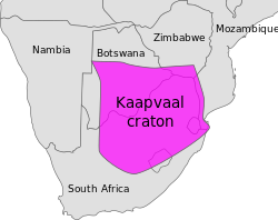
The geology of South Africa is highly varied including cratons, greenstone belts, large impact craters as well as orogenic belts. The geology of the country is the base for a large mining sector that extracts gold, diamonds, iron and coal from world-class deposits. The geomorphology of South Africa consists of a high plateau rimmed to west, south and southeast by the Great Escarpment, and the rugged mountains of the Cape Fold Belt. Beyond this there is strip of narrow coastal plain. [1]

Contents

Cratons and orogens

The magenta-colored area shows the present-day extent of the Kaapvaal Craton. Map of Kaapvaal craton.svg
The magenta-colored area shows the present-day extent of the Kaapvaal Craton.

The basement of much of the northeastern part of South Africa is made up by the Kaapvaal Craton. To the south and east, the craton is bordered by the Namaqua-Natal belt. [2]

In Neoproterozoic times, much of South Africa stabilized into the large Kalahari Craton that came to form part of the supercontinent Rodinia. The Kalahari Craton was near the center of Rodinia with paleogeographic reconstructions indicating it was surrounded by the cratons of Laurentia, Río de la Plata, Congo and Dronning Maud Land. [3] Evidence of this is the continuation of the Namaqua-Natal belt in East Antarctica indicating that South Africa and East Antarctica formed a single continent when this belt formed about 1000 million years ago. [2]

Tectonics and erosion since the Mesozoic

Since the Mesozoic the tectonics of South Africa have been shaped by an initial phase of rifting [4] and then by episodic epeirogenic movements. [5] South Africa is currently an elevated passive margin much like Eastern Greenland and the Brazilian Highlands. [6] The uplift of these margins is tentatively related to far-field compressional stresses that has warped the region as a giant anticline-like lithosphere fold. [7] These tectonics have had a profound effect in shaping the Great Escarpment and uplifting, creating and destroying plateaux including the African Surface, a key reference surface. [4] On average, 2.5 to 3.5 km rock was eroded in the Mid to Late Cretaceous. Further erosion in Cenozoic times amount to less than one kilometer. [5] Limited erosion means that many of the major relief features of South Africa have existed since the Late Cretaceous. [8] Warping of Southern Africa has led to significant changes in drainage basins with the Orange River likely losing a drainage area in the Kalahari Basin, the Limpopo River losing interior drainage areas to the Zambezi River and the west-draining Karoo River ceasing to exist altogether. [9] Overall, the boundaries of the drainage basins coincide with the axes of uplifted epeirogenic flexures. [10]

Partridge and Maud (1987) links tectonics to three cycles of landscape development: African, Post-African I and Post-African II: [4]

Stratigraphy

An approximate SW-NE geological cross section through South Africa, with the Cape Peninsula (with Table Mountain) on the far left, and north-eastern KwaZulu-Natal on the right. Diagrammatic and only roughly to scale to scale. The difference in both composition and structure of the Cape Fold Mountains and the Central Plateau surrounded by the Great Escarpment, in particular the Drakensberg, can clearly be seen. SW-NE geological cross section through South Africa.jpg
An approximate SW-NE geological cross section through South Africa, with the Cape Peninsula (with Table Mountain) on the far left, and north-eastern KwaZulu-Natal on the right. Diagrammatic and only roughly to scale to scale. The difference in both composition and structure of the Cape Fold Mountains and the Central Plateau surrounded by the Great Escarpment, in particular the Drakensberg, can clearly be seen.

Cape Supergroup

The Cape Supergroup is divided into several distinct Groups. The western and southern extents of the Supergroup have been folded into a series of longitudinal mountain ranges, by the collision of the Falkland Plateau into what would later become South Africa. However, the entire suite in this region slopes downwards towards the north and east, so that the oldest rocks are exposed in the south and west, while the youngest members of the Supergroup are exposed in the north, where the entire Cape Supergroup dives beneath the Karoo rocks. Drilling in the Karoo has established that Cape Supergroup rocks are found below the surface up to approximately 150 km north of their northernmost exposure on the surface. The Cape Supergroup extends eastwards beyond the Fold into the northern Eastern Cape and KwaZulu-Natal, where no folding took place. [12]

Karoo Supergroup

The Karoo Supergroup is the most widespread stratigraphic unit in Africa south of the Sahara Desert. The supergroup consists of a sequence of units, mostly of nonmarine origin, deposited between the Late Carboniferous and Early Jurassic, a period of about 120 million years. [13]

Transvaal Supergroup

The Transvaal Supergroup is a stratigraphic unit in northern South Africa and southern Botswana, situated on the Kaapvaal Craton, roughly between 23 and 29 degrees southern latitude and 22 to 30 degrees eastern longitude. It is dated to the boundary between the Archean and Proterozoic eras, roughly 2,500 Mya. It is delimited by the Witwatersrand Basin (2,700 Mya) and the Bushveld Igneous Complex (2,050 Mya).

Mineral resources

Diamond and gold production are now well down from their peaks. As of 2012, South Africa was the world's fifth-largest producer of gold but South Africa still possesses the world's second-largest reserves of gold. [14] It is the world's largest producer of chromium, manganese, platinum, vanadium and vermiculite and the second largest producer of ilmenite, palladium, rutile and zirconium. [15] South Africa is one of the ten largest coal producing countries in the world. [16] [17] South Africa is also a huge producer of iron ore; in 2012, it overtook India to become the world's third biggest iron ore supplier to China, which is the world's largest consumer of iron ore. [18]

Prince Edward Islands

Marion Island Marion Island, South Africa, EO-1 ALI satellite image, 5 May 2009.jpg
Marion Island

The Prince Edward Islands are a pair of islands in the south Indian Ocean; they are the country's only offshore islands. Both islands are of volcanic origin. Marion Island is the larger of the two islands and is one of the peaks of a large underwater shield volcano that rises some 5,000 metres (16,404 ft) from the sea floor to the top of Mascarin Peak. It is the only active South African volcano, with eruptions having occurred between 1980 and 2004. [19]

See also

Related Research Articles

<span class="mw-page-title-main">Geology of the Appalachians</span> Geologic description of the Appalachian Mountains

The geology of the Appalachians dates back more than 1.2 billion years to the Mesoproterozoic era when two continental cratons collided to form the supercontinent Rodinia, 500 million years prior to the development of the range during the formation of Pangea. The rocks exposed in today's Appalachian Mountains reveal elongate belts of folded and thrust faulted marine sedimentary rocks, volcanic rocks, and slivers of ancient ocean floor—strong evidences that these rocks were deformed during plate collision. The birth of the Appalachian ranges marks the first of several mountain building plate collisions that culminated in the construction of Pangea with the Appalachians and neighboring Anti-Atlas mountains near the center. These mountain ranges likely once reached elevations similar to those of the Alps and the Rocky Mountains before they were eroded.

<span class="mw-page-title-main">Congo Craton</span> Precambrian craton that with four others makes up the modern continent of Africa

The Congo Craton, covered by the Palaeozoic-to-recent Congo Basin, is an ancient Precambrian craton that with four others makes up the modern continent of Africa. These cratons were formed between about 3.6 and 2.0 billion years ago and have been tectonically stable since that time. All of these cratons are bounded by younger fold belts formed between 2.0 billion and 300 million years ago.

<span class="mw-page-title-main">Karoo Supergroup</span> Widespread Mesozoic stratigraphic unit in southern Africa

The Karoo Supergroup is the most widespread stratigraphic unit in Africa south of the Kalahari Desert. The supergroup consists of a sequence of units, mostly of nonmarine origin, deposited between the Late Carboniferous and Early Jurassic, a period of about 120 million years.

<span class="mw-page-title-main">Cape Fold Belt</span> Late Paleozoic fold and thrust belt in southwestern South Africa

The Cape Fold Belt is a fold and thrust belt of late Paleozoic age, which affected the sequence of sedimentary rock layers of the Cape Supergroup in the southwestern corner of South Africa. It was originally continuous with the Ventana Mountains near Bahía Blanca in Argentina, the Pensacola Mountains, the Ellsworth Mountains and the Hunter-Bowen orogeny in eastern Australia. The rocks involved are generally sandstones and shales, with the shales persisting in the valley floors while the erosion resistant sandstones form the parallel ranges, the Cape Fold Mountains, which reach a maximum height of 2325 m at Seweweekspoortpiek.

The natural history of Australia has been shaped by the geological evolution of the Australian continent from Gondwana and the changes in global climate over geological time. The building of the Australian continent and its association with other land masses, as well as climate changes over geological time, have created the unique flora and fauna present in Australia today.

<span class="mw-page-title-main">Vaalbara</span> Archaean supercontinent from about 3.6 to 2.7 billion years ago

Vaalbara is a hypothetical Archean supercontinent consisting of the Kaapvaal Craton and the Pilbara Craton. E. S. Cheney derived the name from the last four letters of each craton's name. The two cratons consist of continental crust dating from 2.7 to 3.6 Ga, which would make Vaalbara one of Earth's earliest supercontinents.

<span class="mw-page-title-main">Kalahari Craton</span> African geological area

The Kalahari Craton is a craton, an old and stable part of the continental lithosphere, that occupies large portions of South Africa, Botswana, Namibia and Zimbabwe. It consists of two cratons separated by the Limpopo Belt: the larger Kaapvaal Craton to the south and the smaller Zimbabwe Craton to the north. The Namaqua Belt is the southern margin of the Kaapvaal Craton.

In geology, epeirogenic movement is upheavals or depressions of land exhibiting long wavelengths and little folding apart from broad undulations. The broad central parts of continents are called cratons, and are subject to epeirogeny. The movement may be one of subsidence toward, or of uplift from, the center of Earth. The movement is caused by a set of forces acting along an Earth radius, such as those contributing to isostasy and faulting in the lithosphere.

<span class="mw-page-title-main">Ur (continent)</span> Hypothetical Archaean supercontinent from about 3.1 billion years ago

Ur is a hypothetical supercontinent that formed in the Archean eon around 3.1 billion years ago (Ga). In a reconstruction by Rogers, Ur is half a billion years older than Arctica and, in the early period of its existence, probably the only continent on Earth, making it a supercontinent despite probably being smaller than present-day Australia. In more recent works geologists often refer to both Ur and other proposed Archaean continental assemblages as supercratons. Ur can, nevertheless, be half a billion years younger than Vaalbara, but the concepts of these two early cratonic assemblages are incompatible.

This is a list of articles related to plate tectonics and tectonic plates.

<span class="mw-page-title-main">East Antarctic Shield</span> Cratonic rock body which makes up most of the continent Antarctica

The East Antarctic Shield or Craton is a cratonic rock body that covers 10.2 million square kilometers or roughly 73% of the continent of Antarctica. The shield is almost entirely buried by the East Antarctic Ice Sheet that has an average thickness of 2200 meters but reaches up to 4700 meters in some locations. East Antarctica is separated from West Antarctica by the 100–300 kilometer wide Transantarctic Mountains, which span nearly 3,500 kilometers from the Weddell Sea to the Ross Sea. The East Antarctic Shield is then divided into an extensive central craton that occupies most of the continental interior and various other marginal cratons that are exposed along the coast.

<span class="mw-page-title-main">Tectonic evolution of Patagonia</span>

Patagonia comprises the southernmost region of South America, portions of which lie on either side of the Argentina-Chile border. It has traditionally been described as the region south of the Rio, Colorado, although the physiographic border has more recently been moved southward to the Huincul fault. The region's geologic border to the north is composed of the Rio de la Plata craton and several accreted terranes comprising the La Pampa province. The underlying basement rocks of the Patagonian region can be subdivided into two large massifs: the North Patagonian Massif and the Deseado Massif. These massifs are surrounded by sedimentary basins formed in the Mesozoic that underwent subsequent deformation during the Andean orogeny. Patagonia is known for its vast earthquakes and the damage they cause.

<span class="mw-page-title-main">Owambo Basin</span>

The Owambo Basin is a sedimentary basin located on the Congo Craton in Southern Africa that extends from southern Angola into Namibia and includes the Etosha Pan. It is bound on the southern and western sides by the Damara Belt in Northern Namibia, and by the Cubango River to the East. The northern boundary is scientifically disputed, but is currently mapped by most stratigraphers to include southern Angola with the boundary set at the Kunene River. The Owambo Basin is host to two famous regions: Tsumeb, a major Namibian city and site of a formerly active copper mine with exceptional mineralogical variability producing museum quality rare specimens, and Etosha National Park, the largest protected wildlife sanctuary in Namibia centered around Etosha Pan.

<span class="mw-page-title-main">Geology of the Republic of the Congo</span>

The geology of the Republic of the Congo, also known as Congo-Brazzaville, to differentiate from the Democratic Republic of the Congo, formerly Zaire, includes extensive igneous and metamorphic basement rock, some up to two billion years old and sedimentary rocks formed within the past 250 million years. Much of the country's geology is hidden by sediments formed in the past 2.5 million years of the Quaternary.

The geology of Lesotho is built on ancient crystalline basement rock up to 3.6 billion years old, belonging to the Kaapvaal Craton, a section of stable primordial crust. Most of the rocks in the country are sedimentary or volcanic units, belonging to the Karoo Supergroup. The country is notable for large fossil deposits and intense erosion due to high rainfall and a rare case of southern African glaciation during the last ice age. Lesotho has extensive diamonds and other natural resources and has the highest concentration of kimberlite pipes anywhere in the world.

The geology of Malawi formed on extremely ancient crystalline basement rock, which was metamorphosed and intruded by igneous rocks during several orogeny mountain building events in the past one billion years. The rocks of the Karoo Supergroup and newer sedimentary units deposited across much of Malawi in the last 251 million years, in connection with a large rift basin on the supercontinent Gondwana and the more recent rifting that has created the East African Rift, which holds Lake Malawi. The country has extensive mineral reserves, many of them poorly understood or not exploited, including coal, vermiculite, rare earth elements and bauxite.

The geology of Mozambique is primarily extremely old Precambrian metamorphic and igneous crystalline basement rock, formed in the Archean and Proterozoic, in some cases more than two billion years ago. Mozambique contains greenstone belts and spans the Zimbabwe Craton, a section of ancient stable crust. The region was impacted by major tectonic events, such as the mountain building Irumide orogeny, Pan-African orogeny and the Snowball Earth glaciation. Large basins that formed in the last half-billion years have filled with extensive continental and marine sedimentary rocks, including rocks of the extensive Karoo Supergroup which exist across Southern Africa. In some cases these units are capped by volcanic rocks. As a result of its complex and ancient geology, Mozambique has deposits of iron, coal, gold, mineral sands, bauxite, copper and other natural resources.

<span class="mw-page-title-main">Geology of Namibia</span>

The geology of Namibia encompasses rocks of Paleoproterozoic, Mesoproterozoic and Neoproterozoic and Paleozoic to Cenozoic age. About 46% of the countryʼs surface are bedrock exposure, while the remainder is covered by the young overburden sediments of the Kalahari and Namib deserts.

<span class="mw-page-title-main">Geology of Tanzania</span>

The geology of Tanzania began to form in the Precambrian, in the Archean and Proterozoic eons, in some cases more than 2.5 billion years ago. Igneous and metamorphic crystalline basement rock forms the Archean Tanzania Craton, which is surrounded by the Proterozoic Ubendian belt, Mozambique Belt and Karagwe-Ankole Belt. The region experienced downwarping of the crust during the Paleozoic and Mesozoic, as the massive Karoo Supergroup deposited. Within the past 100 million years, Tanzania has experienced marine sedimentary rock deposition along the coast and rift formation inland, which has produced large rift lakes. Tanzania has extensive, but poorly explored and exploited natural resources, including coal, gold, diamonds, graphite and clays.

The geology of Eswatini formed beginning 3.6 billion years ago, in the Archean Eon of the Precambrian. Eswatini is the only country entirely underlain by the Kaapvaal Craton, one of the oldest pieces of stable continental crust and the only craton regarded as "pristine" by geologists, other than the Yilgarn Craton in Australia. As such, the country has very ancient granite, gneiss and in some cases sedimentary rocks from the Archean into the Proterozoic, overlain by sedimentary rocks and igneous rocks formed during the last 539 million years of the Phanerozoic as part of the Karoo Supergroup. Intensive weathering has created thick zones of saprolite and heavily weathered soils.

References

  1. "The World Factbook - South Africa". Cia.gov. Retrieved 2015-04-30.
  2. 1 2 Jacobs, J.; Thomas, R.J.; Weber, K (1993). "Accretion and indentation tectonics at the southern edge of the Kaapvaal craton during the Kibaran (Grenville) orogeny". Geology. 21 (3): 203–206. Bibcode:1993Geo....21..203J. doi:10.1130/0091-7613(1993)021<0203:aaitat>2.3.co;2.
  3. Li, Z.X.; Bogdanova, S.V.; Collins, A.S.; Davidson, A.; De Waele, B.; Fitzsimons, I.C.W.; Fuck, R.A.; Gladkochub, D.P.; Jacobs, J.; Karlstrom, K.E.; Lu, S.; Natapov, L.M.; Pease, V.; Pisarevsky, S.A.; Thrane, K.; Vernikovsky, V. (2008). "Assembly, configuration, and break-up history of Rodinia: A synthesis". Precambrian Research . 160 (1–2): 179–210. Bibcode:2008PreR..160..179L. doi:10.1016/j.precamres.2007.04.021.
  4. 1 2 3 4 5 6 Partridge, T.C.; Maud, R.R. (1987). "Geomorphic evolution of southern Africa since the Mesozoic". South African Journal of Geology . 90 (2): 179–208.
  5. 1 2 Tinker, Justine; de Wit, Maarten; Roderick, Brown (2008). "Mesozoic exhumation of the southern Cape, South Africa, quantified using apatite fission track thermochronology". Tectonophysics. 455 (1–4): 77–93. Bibcode:2008Tectp.455...77T. doi:10.1016/j.tecto.2007.10.009.
  6. Green, Paul F.; Lidmar-Bergström, Karna; Japsen, Peter; Bonow, Johan M.; Chalmers, James A. (2013). "Stratigraphic landscape analysis, thermochronology and the episodic development of elevated, passive continental margins". Geological Survey of Denmark and Greenland Bulletin . 30: 18. doi: 10.34194/geusb.v30.4673 .
  7. Japsen, Peter; Chalmers, James A.; Green, Paul F.; Bonow, Johan M. (2012). "Elevated, passive continental margins: Not rift shoulders, but expressions of episodic, post-rift burial and exhumation". Global and Planetary Change . 90–91: 73–86. Bibcode:2012GPC....90...73J. doi:10.1016/j.gloplacha.2011.05.004.
  8. 1 2 3 Baby, Guillaume (2016). "Mass transfer between the South African Plateau and the adjacent Atlantic Margin (Namibia - South Africa) since the Gondwana break-up". Source to Sink: a long term perspective of sediment budgets and sources characterization. Rennes, France. pp. 33–34.
  9. 1 2 Goudie, A.S. (2005). "The drainage of Africa since the Cretaceous". Geomorphology . 67 (3–4): 437–456. Bibcode:2005Geomo..67..437G. doi:10.1016/j.geomorph.2004.11.008.
  10. Moore, A.E. (1999). "A reapprisal of epeirogenic flexure axes in southern Africa". South African Journal of Geology . 102 (4): 363–376.
  11. 1 2 Guillocheau, François; Simon, Brendon; Baby, Guillaume; Bessin, Paul; Robin, Cécile; Dauteuil, Olivier (2017). "Planation surfaces as a record of mantle dynamics: The case example of Africa" (PDF). Gondwana Research . 53: 82–98. doi:10.1016/j.gr.2017.05.015.
  12. Truswell, J. F. (1977). The geological evolution of South Africa. Cape Town: Purnell. pp. 93–96, 114–159. ISBN   978-0-360-00290-6.
  13. Schlüter, Thomas (2008). Geological Atlas of Africa: With Notes on Stratigraphy, Tectonics, Economic Geology, Geohazards and Geosites of Each Country (2nd ed.). Springer. pp. 26–28. ISBN   978-3-540-76373-4.
  14. "U.S. Geological Survey, Mineral Commodity Summaries, January 2013" (PDF). United States Geological Survey. January 2013.
  15. "USGS Minerals Information: Mineral Commodity Summaries". Minerals.usgs.gov. 2015-01-30. Retrieved 2015-04-30.
  16. Schmidt, Stephan. "Coal deposits of South Africa - the future of coal mining in South Africa" (PDF). Institute for Geology, Technische Universität Bergakademie Freiberg . Retrieved 14 January 2010.
  17. "Coal Mining". World Coal Institute . Retrieved 14 January 2010.
  18. "SA replaces India as China's No 3 iron-ore supplier". Mining Weekly. 2013-01-21.
  19. "Marion Island". Global Volcanism Program . Retrieved 2015-04-30.

Further reading