Related Research Articles
The Llano Uplift is a geologically ancient, low geologic dome that is about 90 miles (140 km) in diameter and located mostly in Llano, Mason, San Saba, Gillespie, and Blanco counties, Texas. It consists of an island-like exposure of Precambrian igneous and metamorphic rocks surrounded by outcrops of Paleozoic and Cretaceous sedimentary strata. At their widest, the exposed Precambrian rocks extend about 65 miles (105 km) westward from the valley of the Colorado River and beneath a broad, gentle topographic basin drained by the Llano River. The subdued topographic basin is underlain by Precambrian rocks and bordered by a discontinuous rim of flat-topped hills. These hills are the dissected edge of the Edwards Plateau, which consist of overlying Cretaceous sedimentary strata. Within this basin and along its margin are down-faulted blocks and erosional remnants of Paleozoic strata which form prominent hills.

The Niger Delta Basin, also referred to as the Niger Delta province, is an extensional rift basin located in the Niger Delta and the Gulf of Guinea on the passive continental margin near the western coast of Nigeria with suspected or proven access to Cameroon, Equatorial Guinea and São Tomé and Príncipe. This basin is very complex, and it carries high economic value as it contains a very productive petroleum system. The Niger delta basin is one of the largest subaerial basins in Africa. It has a subaerial area of about 75,000 km2, a total area of 300,000 km2, and a sediment fill of 500,000 km3. The sediment fill has a depth between 9–12 km. It is composed of several different geologic formations that indicate how this basin could have formed, as well as the regional and large scale tectonics of the area. The Niger Delta Basin is an extensional basin surrounded by many other basins in the area that all formed from similar processes. The Niger Delta Basin lies in the south westernmost part of a larger tectonic structure, the Benue Trough. The other side of the basin is bounded by the Cameroon Volcanic Line and the transform passive continental margin.
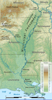
The Mississippi embayment is a physiographic feature in the south-central United States, part of the Mississippi Alluvial Plain. It is essentially a northward continuation of the fluvial sediments of the Mississippi River Delta to its confluence with the Ohio River at Cairo, Illinois. The current sedimentary area was formed in the Cretaceous and early Cenozoic by the filling with sediment of a pre-existing basin. An explanation for the embayment's formation was put forward by Van Arsdale and Cox in 2007: movement of the earth's crust brought this region over a volcanic "hotspot" in the Earth's mantle causing an upthrust of magma which formed the Appalachian-Ouachita range. Subsequent erosion caused a deep trough that was flooded by the Gulf of Mexico and eventually filled with sediment from the Mississippi River.

Algoasaurus is a genus of sauropod dinosaur from the Berriasian-early Valanginian-age Early Cretaceous Upper Kirkwood Formation of Cape Province, South Africa, specifically near a town called Despatch.

Paranthodon is a genus of stegosaurian dinosaur that lived in what is now South Africa during the Early Cretaceous, between 139 and 131 million years ago. Discovered in 1845, it was one of the first stegosaurians found. Its only remains, a partial skull, isolated teeth, and fragments of vertebrae, were found in the Kirkwood Formation. British paleontologist Richard Owen initially identified the fragments as those of the pareiasaur Anthodon. After remaining untouched for years in the British Museum of Natural History, the partial skull was identified by South African paleontologist Robert Broom as belonging to a different genus; he named the specimen Palaeoscincus africanus. Several years later, Hungarian paleontologist Franz Nopcsa, unaware of Broom's new name, similarly concluded that it represented a new taxon, and named it Paranthodon owenii. Since Nopcsa's species name was assigned after Broom's, and Broom did not assign a new genus, both names are now synonyms of the current binomial, Paranthodon africanus. The genus name combines the Ancient Greek para (near) with the genus name Anthodon, to represent the initial referral of the remains.
Nqwebasaurus is a basal coelurosaur and is the basal-most member of the coelurosaurian clade Ornithomimosauria from the Early Cretaceous of South Africa. The name Nqwebasaurus is derived from the Xhosa word "Nqweba" which is the local name for the Kirkwood district, and "thwazi" is ancient Xhosa for "fast runner". Currently it is the oldest coelurosaur in Africa and shows that basal coelurosaurian dinosaurs inhabited Gondwana 50 million years earlier than previously thought. The type specimen of Nqwebasaurus was discovered by William J. de Klerk who is affiliated with the Albany Museum in Grahamstown. It is the only fossil of its species found to date and was found in the Kirkwood Formation of the Uitenhage Group. Nqwebasaurus has the unofficial nickname "Kirky", due to being found in the Kirkwood.

The Tendaguru Formation, or Tendaguru Beds are a highly fossiliferous formation and Lagerstätte located in the Lindi Region of southeastern Tanzania. The formation represents the oldest sedimentary unit of the Mandawa Basin, overlying Neoproterozoic basement, separating by a long hiatus and unconformity. The formation reaches a total sedimentary thickness of more than 110 metres (360 ft). The formation ranges in age from the late Middle Jurassic to the Early Cretaceous, Oxfordian to Hauterivian stages, with the base of the formation possibly extending into the Callovian.

Axelrodichthys is an extinct genus of mawsoniid coelacanth from the Cretaceous of Africa, North and South America, and Europe. Several species are known, the remains of which were discovered in the Lower Cretaceous (Aptian-Albian) of Brazil, North Africa, and possibly Mexico, as well as in the Upper Cretaceous of Morocco (Cenomanian), Madagascar and France. The Axelrodichthys of the Lower Cretaceous frequented both brackish and coastal marine waters while the most recent species lived exclusively in fresh waters. The French specimens are the last known fresh water coelacanths. Most of the species of this genus reached 1 metre to 2 metres in length. Axelrodichthys was named in 1986 by John G. Maisey in honor of the American ichthyologist Herbert R. Axelrod.
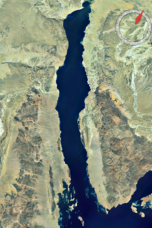
The Gulf of Suez Rift is a continental rift zone that was active between the Late Oligocene and the end of the Miocene. It represented a continuation of the Red Sea Rift until break-up occurred in the middle Miocene, with most of the displacement on the newly developed Red Sea spreading centre being accommodated by the Dead Sea Transform. During its brief post-rift history, the deepest part of the remnant rift topography has been filled by the sea, creating the Gulf of Suez.

The Camarillas Formation is a geological formation in the Teruel Province of Aragón, Spain whose strata date back to the Early Cretaceous. The sandstones, mudstones and conglomerates of the formation, that due to syn-sedimentary faulting varies greatly in thickness from 300 to 800 metres, were deposited in fluvial, deltaic and lacustrine environments.
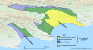
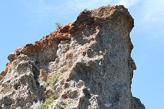
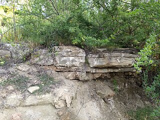
The Kirkwood Formation is a geological formation found in the Eastern and Western Cape provinces in South Africa. It is one of the four formations found within the Uitenhage Group of the Algoa Basin – its type locality – and in the neighbouring Gamtoos Basin. Outcrops of the Kirkwood are also found along the Worcester-Pletmos, Herbertsdale-Riversdale, Heidelberg-Mossel Bay, and Oudtshoorn-Gamtoos basin lines. At these basins the Kirkwood Formation underlies the Buffelskloof Formation and not the Sundays River Formation.
The Enon Formation is a geological formation found in the Eastern and Western Cape provinces in South Africa. It is the lowermost of the four formations found within the Uitenhage Group of the Algoa Basin, its type locality, where it has been measured at a maximum thickness of 480 metres (1,570 ft). Discontinuous outcrops are also found in the Worcester-Pletmos and Oudshoorn-Gamtoos Basins, including isolated occurrences in the Haasvlakte, Jubilee, and Soutpansvlakte Basins near the small town Bredasdorp.
The Sundays River Formation is a geological formation found in the Eastern and Western Cape provinces in South Africa. It is the second youngest of the four formations found within the Uitenhage Group of the Algoa Basin, its type locality, and the only location where outcrops have been located. The Sundays River has been measured at a maximum thickness of 2,000 metres (6,600 ft).
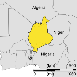
The Iullemmeden Basin is a major sub-Saharan inland basin in West Africa, extending about 1,000 kilometres (620 mi) north to south and 800 kilometres (500 mi) east to west. It covers western Niger and parts of Algeria, Mali and Nigeria. It is named after the Iullemmeden, a federation of Tuareg people who live in the central region of Niger. Its geographic range is largely coincident with the Azawagh region.
The Angola Basin is located along the West African South Atlantic Margin which extends from Cameroon to Angola. It is characterized as a passive margin that began spreading in the south and then continued upwards throughout the basin. This basin formed during the initial breakup of the supercontinent Pangaea during the early Cretaceous, creating the Atlantic Ocean and causing the formation of the Angola, Cape, and Argentine basins. It is often separated into two units: the Lower Congo Basin, which lies in the northern region and the Kwanza Basin which is in the southern part of the Angola margin. The Angola Basin is famous for its "Aptian Salt Basins," a thick layer of evaporites that has influenced topography of the basin since its deposition and acts as an important petroleum reservoir.
The geology of South Africa is highly varied including cratons, greenstone belts, large impact craters as well as orogenic belts. The geology of the country is the base for a large mining sector that extracts gold, diamonds, iron and coal from world-class deposits. The geomorphology of South Africa consists of a high plateau rimmed to west, south and southeast by the Great Escarpment, and the rugged mountains of the Cape Fold Belt. Beyond this there is strip of narrow coastal plain.
The Uitenhage Group is one of three geological groups, which comprise the onshore and offshore post-Karoo middle to lower Upper Mesozoic geological rock units in South Africa. Stratigraphically, the Uitenhage Group overlies the Suurberg Group and is overlain by the Algoa Group. It contains four formations that range in age from late Early Jurassic and late Early Cretaceous in age.
The Algoa Group is one of five geological groups which comprise the coastal Cenozoic geological deposits in South Africa. The Algoa Group contains six formations which range from Middle Eocene to Late Holocene in age.

The Buffelskloof Formation is a geological formation found in the Western Cape province in South Africa. It is the uppermost of the four formations found within the Uitenhage Group of the Algoa Basin. It is considered an informal formation by some of the literature as it is very thin and only outcrops as isolated horizons in the Oudshoorn-Gamtoos, Herbertsdale-Mossel Bay, and Heidelberg-Riversdale Basins. Along the Worcester-Pletmos Basin, it occurs in patches along the southern flanks of the Langeberg mountain range - from Worcester in the west and as far as Mossel Bay in the east. From Mossel Bay this formation is inter fingered by the informal Hartenbos Formation. The Buffelskloof and Hartenbos Formations only occur in the Oudshoorn-Gamtoos and Herbertsdale-Mossel Bay basins and seem to correlate to the Sundays River Formation in age.
Iyuku is a genus of iguanodontian dinosaur from the Early Cretaceous Kirkwood Formation of South Africa. The type species is Iyuku raathi.
References
- ↑ Muir, Robert A., Emese M. Bordy, and Rose Prevec (2015). "Lower Cretaceous deposit reveals first evidence of a post-wildfire debris flow in the Kirkwood Formation, Algoa Basin, Eastern Cape, South Africa." Cretaceous Research, 56, 161–179.
- ↑ Gomez, Bernard, Martínez‐Delclòs, Xavier, Bamford, Marion, & Philippe, Marc (2002). Taphonomy and palaeoecology of plant remains from the oldest African Early Cretaceous amber locality. Lethaia, 35(4), 300–308.
| | This South Africa location article is a stub. You can help Wikipedia by expanding it. |
| | This article about a regional geological feature is a stub. You can help Wikipedia by expanding it. |