Geology of Lincolnshire

Last updated
This article describes the geology of the ceremonial county of Lincolnshire. Besides the modern administrative county, it includes the unitary authority areas of North Lincolnshire and North East Lincolnshire.

The geology of Lincolnshire in eastern England largely consists of an easterly dipping succession of Mesozoic age sedimentary rocks, obscured across large parts of the county by unconsolidated deposits dating from the last few hundred thousand years of the present Quaternary Period. [1]

England Country in north-west Europe, part of the United Kingdom

England is a country that is part of the United Kingdom. It shares land borders with Wales to the west and Scotland to the north. The Irish Sea lies west of England and the Celtic Sea to the southwest. England is separated from continental Europe by the North Sea to the east and the English Channel to the south. The country covers five-eighths of the island of Great Britain, which lies in the North Atlantic, and includes over 100 smaller islands, such as the Isles of Scilly and the Isle of Wight.

The Mesozoic Era is an interval of geological time from about 252 to 66 million years ago. It is also called the Age of Reptiles and the Age of Conifers.

Sedimentary rock Rock formed by the deposition and subsequent cementation of material

Sedimentary rocks are types of rock that are formed by the accumulation or deposition of small particles and subsequent cementation of mineral or organic particles on the floor of oceans or other bodies of water at the Earth's surface. Sedimentation is the collective name for processes that cause these particles to settle in place. The particles that form a sedimentary rock are called sediment, and may be composed of geological detritus (minerals) or biological detritus. Before being deposited, the geological detritus was formed by weathering and erosion from the source area, and then transported to the place of deposition by water, wind, ice, mass movement or glaciers, which are called agents of denudation. Biological detritus was formed by bodies and parts of dead aquatic organisms, as well as their fecal mass, suspended in water and slowly piling up on the floor of water bodies. Sedimentation may also occur as dissolved minerals precipitate from water solution.

Contents

Triassic

The oldest rocks exposed at or near the surface of Lincolnshire are the sandstones and mudstones of the early Triassic Sherwood Sandstone Group. Rocks from this and the overlying Mercia Mudstone and Penarth groups occur in the northwest of the county and along its western border but are generally concealed beneath a thick cover of recent deposits.

Sandstone A clastic sedimentary rock composed mostly of sand-sized particles

Sandstone is a clastic sedimentary rock composed mainly of sand-sized mineral particles or rock fragments.

Mudstone Fine grained sedimentary rock whose original constituents were clays or muds

Mudstone, a type of mudrock, is a fine-grained sedimentary rock whose original constituents were clays or muds. Grain size is up to 0.063 millimetres (0.0025 in) with individual grains too small to be distinguished without a microscope. With increased pressure over time, the platy clay minerals may become aligned, with the appearance of fissility or parallel layering. This finely bedded material that splits readily into thin layers is called shale, as distinct from mudstone. The lack of fissility or layering in mudstone may be due to either original texture or the disruption of layering by burrowing organisms in the sediment prior to lithification. Mud rocks such as mudstone and shale account for some 65% of all sedimentary rocks. Mudstone looks like hardened clay and, depending upon the circumstances under which it was formed, it may show cracks or fissures, like a sun-baked clay deposit.

The Triassic is a geologic period and system which spans 50.6 million years from the end of the Permian Period 251.9 million years ago (Mya), to the beginning of the Jurassic Period 201.3 Mya. The Triassic is the first and shortest period of the Mesozoic Era. Both the start and end of the period are marked by major extinction events.

Jurassic

A range of rocks from the Jurassic Period occur within a broadly north-south outcrop which tapers markedly northwards from the Fens to the banks of the Humber around Whitton and Winteringham. The lowermost and most westerly are the early Jurassic mudstones and limestones of the Lias Group, overlain in turn by the middle Jurassic Inferior Oolite and Great Oolite groups which comprise a mix of limestones, mudstones and sandstones and then the late Jurassic mudstones, limestones, sandstones and siltstones of the Corallian Group and succeeding West Walton Formation. Lincoln Edge is formed by the Oolite Group limestones.

The Jurassic is a geologic period and system that spanned 56 million years from the end of the Triassic Period 201.3 million years ago (Mya) to the beginning of the Cretaceous Period 145 Mya. The Jurassic constitutes the middle period of the Mesozoic Era, also known as the Age of Reptiles. The start of the period was marked by the major Triassic–Jurassic extinction event. Two other extinction events occurred during the period: the Pliensbachian-Toarcian extinction in the Early Jurassic, and the Tithonian event at the end; neither event ranks among the "Big Five" mass extinctions, however.

The Fens Natural region in United Kingdom

The Fens, also known as the Fenlands, are a coastal plain in eastern England. This natural marshy region supported a rich ecology and numerous species, as well as absorbing storms. Most of the fens were drained several centuries ago, resulting in a flat, dry, low-lying agricultural region supported by a system of drainage channels and man-made rivers and automated pumping stations. There have been unintended consequences to this reclamation, as the land level has continued to sink and the dykes must be built higher to protect it from flooding.

Humber Large tidal estuary in England

The Humber is a large tidal estuary on the east coast of Northern England. It is formed at Trent Falls, Faxfleet, by the confluence of the tidal rivers Ouse and Trent. From there to the North Sea, it forms part of the boundary between the East Riding of Yorkshire on the north bank and North Lincolnshire on the south bank. Although the Humber is an estuary from the point at which it is formed, many maps show it as the River Humber.

Cretaceous

The Cretaceous sequence begins with the Wealden Group limestones, mudstones, sandstones and siltstones which occur from Gibraltar Point in a band which narrows northwestwards to the Caistor area. To their east, and stratigraphically above them, are the sandstones of the Lower Greensand Group and beyond them the Chalk which gives rise to the Lincolnshire Wolds and extends to the North Sea coast but is obscured along the coastal margin.

The Cretaceous is a geologic period and system that spans from the end of the Jurassic Period 145 million years ago (mya) to the beginning of the Paleogene Period 66 mya. It is the last period of the Mesozoic Era, and the longest period of the Phanerozoic Eon. The Cretaceous Period is usually abbreviated K, for its German translation Kreide.

The Wealden Group, occasionally also referred to as the Wealden Supergroup, is a group in the lithostratigraphy of southern England. The Wealden group consists of paralic to continental (freshwater) facies sedimentary rocks of Berriasian to Aptian age and thus forms part of the English Lower Cretaceous. It is composed of alternating sands and clays. The sandy units were deposited in a flood plain of braided rivers, the clays mostly in a lagoonal coastal plain.

Gibraltar Point nature reserve in the United Kingdom

Gibraltar Point national nature reserve is an area of about 4.3 km2 (1.7 sq mi) on the coast of Lincolnshire, England.

Quaternary

A wide range of superficial deposits have been laid down across the county in the last couple of million years. Lincolnshire was over-ridden by glacial ice on at least one occasion, that of the Anglian glaciation which left glacial till across much of the county. In the course of the more recent end-Devensian ice age, North Sea ice heading south penetrated inland as far as the eastern slopes of the Lincolnshire Wolds and into the embayment of The Wash. A further tongue of ice advanced southwards from the Vale of York into the northwestern corner of the county as far as the Isle of Axholme. Glacial sands and gravels occur in places along the eastern margin of the Wolds. There are extensive spreads of river, estuarine and coastal alluvium along the North Sea Coast and around the Wash as far inland as Crowland in the south and roughly along the line of the South Forty-Foot Drain. Alluvium also covers the flat floors of the Trent, Witham and Ancholme rivers whilst river terrace sands and gravels are widespread around Woodhall Spa, in the Trent valley and towards Lincoln, along the course of the River Slea and south of Sleaford through Bourne to Market Deeping. Areas of blown sand occur at Donna Nook and inland across an area centred upon Scunthorpe but extending southeast beyond Market Rasen and west to the Yorkshire border. Peat is common around the fenland margin from Walcot to the Cambridgeshire border near Crowland. [2]

Till Unsorted glacial sediment

Till or glacial till is unsorted glacial sediment.

North Sea marginal sea of the Atlantic Ocean

The North Sea is a marginal sea of the Atlantic Ocean located between Great Britain, Denmark, Norway, Germany, the Netherlands, Belgium and France. An epeiric sea on the European continental shelf, it connects to the ocean through the English Channel in the south and the Norwegian Sea in the north. It is more than 970 kilometres (600 mi) long and 580 kilometres (360 mi) wide, with an area of 570,000 square kilometres (220,000 sq mi).

Vale of York

The Vale of York is an area of flat land in the northeast of England. The vale is a major agricultural area and serves as the main north-south transport corridor for Northern England.

See also

Further reading

Related Research Articles

The geology of Cheshire in England consists mainly of Triassic sandstones and mudstones. To the north west of Cheshire, these rocks are heavily faulted and the underlying Carboniferous Coal Measures are thrown up. Around the areas of Poynton and Macclesfield, the coal is close to the surface and was easily mined. Below the Coal Measures is the Millstone Grit, which appears towards the Derbyshire border on the flanks of the Peak District dome.

Geology of Gloucestershire

Gloucestershire is one of the most geologically and scenically diverse counties in England, with rocks from the Precambrian through to the Jurassic represented. These varying rock-types are responsible for the three major areas of the county, each with its own distinctive scenery and land-use - the Forest of Dean in the west, bordering Wales, the Cotswolds in the east, and in between, the Severn Vale.

Geology of Yorkshire

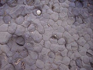
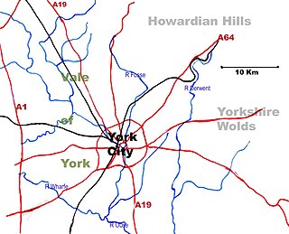
The Geology of Yorkshire in northern England shows a very close relationship between the major topographical areas and the geological period in which their rocks were formed. The rocks of the Pennine chain of hills in the west are of Carboniferous origin whilst those of the central vale are Permo-Triassic. The North York Moors in the north-east of the county are Jurassic in age while the Yorkshire Wolds to the south east are Cretaceous chalk uplands. The plain of Holderness and the Humberhead levels both owe their present form to the Quaternary ice ages. The strata become gradually younger from west to east.

The geology of Monmouthshire in southeast Wales largely consists of a thick series of sedimentary rocks of different types originating in the Silurian, Devonian, Carboniferous, Triassic and Jurassic periods.

Geology of the Isle of Wight

The geology of the Isle of Wight is dominated by sedimentary rocks of Cretaceous and Paleogene age. This sequence was affected by the late stages of the Alpine Orogeny, forming the Isle of Wight monocline, the cause of the steeply-dipping outcrops of the Chalk Group and overlying Paleogene strata seen at The Needles, Alum Bay and Whitecliff Bay.

The geology of Lancashire in northwest England consists in the main of Carboniferous age rocks but with Triassic sandstones and mudstones at or near the surface of the lowlands bordering the Irish Sea though these are largely obscured by Quaternary deposits.

The geology of Cambridgeshire in eastern England largely consists of unconsolidated Quaternary sediments such as marine and estuarine alluvium and peat overlying deeply buried Jurassic and Cretaceous age sedimentary rocks.

The geology of Rutland in eastern England largely consists of sedimentary rocks of Jurassic age which dip gently eastwards.

The geology of Norfolk in eastern England largely consists of late Mesozoic and Cenozoic sedimentary rocks of marine origin covered by an extensive spread of unconsolidated recent deposits.

The geology of Merseyside in northwest England largely consists of a faulted sequence of Carboniferous Coal Measures rocks overlain in the west by younger Triassic and Permian age sandstones and mudstones. Glaciation during the present Quaternary Period has left widespread glacial till as well as erosional landforms. Other post-glacial superficial deposits such as river and estuarine alluvium, peat and blown sand are abundant.

The geology of Tyne and Wear in northeast England largely consists of a suite of sedimentary rocks dating from the Carboniferous and Permian periods into which were intruded igneous dykes during the later Palaeogene Period.

The geology of West Sussex in southeast England comprises a succession of sedimentary rocks of Cretaceous age overlain in the south by sediments of Palaeogene age. The sequence of strata from both periods consists of a variety of sandstones, mudstones, siltstones and limestones. These sediments were deposited within the Hampshire and Weald basins. Erosion subsequent to large scale but gentle folding associated with the Alpine Orogeny has resulted in the present outcrop pattern across the county, dominated by the north facing chalk scarp of the South Downs. The bedrock is overlain by a suite of Quaternary deposits of varied origin. Parts of both the bedrock and these superficial deposits have been worked for a variety of minerals for use in construction, industry and agriculture.

The geology of Northumberland in northeast England includes a mix of sedimentary, intrusive and extrusive igneous rocks from the Palaeozoic and Cenozoic eras. Devonian age volcanic rocks and a granite pluton form the Cheviot massif. The geology of the rest of the county is characterised largely by a thick sequence of sedimentary rocks of Carboniferous age. These are intruded by both Permian and Palaeogene dykes and sills and the whole is overlain by unconsolidated sediments from the last ice age and the post-glacial period. The Whin Sill makes a significant impact on Northumberland's character and the former working of the Northumberland Coalfield significantly influenced the development of the county's economy. The county's geology contributes to a series of significant landscape features around which the Northumberland National Park was designated.

The geology of Israel includes igneous and metamorphic crystalline basement rocks from the Precambrian overlain by a lengthy sequence of sedimentary rocks extending up to the Pleistocene and overlain with alluvium, sand dunes and playa deposits.

This article describes the geology of Dartmoor National Park in Devon, in south-west England. Dartmoor gained national park status in 1951 but the designated area of 954 km2 (368 sq mi) extends beyond the upland of Dartmoor itself to include much of the surrounding land, particularly in the northeast. The geology of the national park consists of a 625 km2 (241 sq mi) core of granite intruded during the early Permian period into a sequence of sedimentary rocks originating in the Devonian and Carboniferous periods. These rocks were faulted and folded, sometimes, intensely, during the Variscan orogeny. Thermal metamorphism has also taken place around the margins of the granite pluton altering the character of the sedimentary rocks whilst mineral veins were emplaced within the granite. A small outlier of Palaeogene sediments occurs on the eastern boundary of the national park.

The geology of national parks in Britain strongly influences the landscape character of each of the fifteen such areas which have been designated. There are ten national parks in England, three in Wales and two in Scotland. Ten of these were established in England and Wales in the 1950s under the provisions of the National Parks and Access to the Countryside Act 1949. With one exception, all of these first ten, together with the two Scottish parks were centred on upland or coastal areas formed from Palaeozoic rocks. The exception is the North York Moors National Park which is formed from sedimentary rocks of Jurassic age.

The geology of Loch Lomond and The Trossachs National Park in the southwestern part of the Scottish Highlands consists largely of Neoproterozoic and Palaeozoic bedrock faulted and folded and subjected to low grade metamorphism during the Caledonian orogeny. These older rocks, assigned to the Dalradian Supergroup, lie to the northwest of the northeast – southwest aligned Highland Boundary Fault which defines the southern edge of the Highlands. A part of this mountainous park extends south of this major geological divide into an area characterised by younger Devonian rocks which are assigned to the Old Red Sandstone.

The geology of Exmoor National Park in south-west England contributes significantly to the character of a landscape which was designated as a national park in 1954. The bedrock of the area consists almost wholly of a suite of sedimentary rocks deposited during the Devonian, a period named for the English county of Devon in which the western half of the park sits. The eastern part lies within Somerset and it is within this part of the park that limited outcrops of Triassic and Jurassic age rocks are to be found.

This article describes the geology of the Brecon Beacons National Park in mid/south Wales. The area gained national park status in 1957 with the designated area of 1,344 km2 (519 sq mi) including mountain massifs to both the east and west of the Brecon Beacons proper. The geology of the national park consists of a thick succession of sedimentary rocks laid down from the late Ordovician through the Silurian and Devonian to the late Carboniferous period. The rock sequence most closely associated with the park is the Old Red Sandstone from which most of its mountains are formed. The older parts of the succession, in the northwest, were folded and faulted during the Caledonian orogeny. Further faulting and folding, particularly in the south of the park is associated with the Variscan orogeny.

The geology of Northumberland National Park in northeast England includes a mix of sedimentary, intrusive and extrusive igneous rocks from the Palaeozoic and Cenozoic eras. Devonian age volcanic rocks and a granite pluton form the Cheviot massif. The geology of the rest of the national park is characterised largely by a thick sequence of sedimentary rocks of Carboniferous age. These are intruded by Permian dykes and sills, of which the Whin Sill makes a significant impact in the south of the park. Further dykes were intruded during the Palaeogene period. The whole is overlain by unconsolidated sediments from the last ice age and the post-glacial period.

References

  1. British Geological Survey 1:625,000 scale geological map Bedrock Geology UK South 5th Edn. NERC 2007
  2. British Geological Survey 1:625,000 scale geological map Quaternary Map of the United Kingdom South 1st Edn. 1977