Related Research Articles

Downland, chalkland, chalk downs or just downs are areas of open chalk hills, such as the North Downs. This term is used to describe the characteristic landscape in southern England where chalk is exposed at the surface. The name "downs" is derived from the Old English word dun, meaning "hill".

The South Downs are a range of chalk hills in the south-eastern coastal counties of England that extends for about 260 sq mi (670 km2) across the south-eastern coastal counties of England from the Itchen valley of Hampshire in the west to Beachy Head, in the Eastbourne Downland Estate, East Sussex, in the east. The Downs are bounded on the northern side by a steep escarpment, from whose crest there are extensive views northwards across the Weald. The South Downs National Park forms a much larger area than the chalk range of the South Downs, and includes large parts of the Weald.

Dorset is a county in South West England on the English Channel coast. Covering an area of 2,653 square kilometres (1,024 sq mi); it borders Devon to the west, Somerset to the north-west, Wiltshire to the north-east, and Hampshire to the east. The great variation in its landscape owes much to the underlying geology, which includes an almost unbroken sequence of rocks from 200 to 40 million years ago (Mya) and superficial deposits from 2 Mya to the present. In general, the oldest rocks appear in the far west of the county, with the most recent (Eocene) in the far east. Jurassic rocks also underlie the Blackmore Vale and comprise much of the coastal cliff in the west and south of the county; although younger Cretaceous rocks crown some of the highpoints in the west, they are mainly to be found in the centre and east of the county.
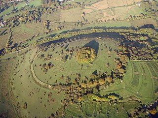
Beacon Hill, Warnford is a 46.4-hectare (115-acre) biological Site of Special Scientific Interest west of Warnford in Hampshire. It is a Nature Conservation Review site, and an area of 40.1 hectares is a national nature reserve. There is a round barrow cemetery dating to the Late Neolithic or Bronze Age on the hill, and this is a scheduled monument.

The geology of England is mainly sedimentary. The youngest rocks are in the south east around London, progressing in age in a north westerly direction. The Tees–Exe line marks the division between younger, softer and low-lying rocks in the south east and the generally older and harder rocks of the north and west which give rise to higher relief in those regions. The geology of England is recognisable in the landscape of its counties, the building materials of its towns and its regional extractive industries.

Chilcomb is a small village and civil parish in the English county of Hampshire 3 miles (4.8 km) east of Winchester and includes the South Downs Way long-distance footpath.

The London Basin is an elongated, roughly triangular sedimentary basin approximately 250 kilometres (160 mi) long which underlies London and a large area of south east England, south eastern East Anglia and the adjacent North Sea. The basin formed as a result of compressional tectonics related to the Alpine orogeny during the Palaeogene period and was mainly active between 40 and 60 million years ago.

The Hampshire Basin is a geological basin of Palaeogene age in southern England, underlying parts of Hampshire, the Isle of Wight, Dorset, and Sussex. Like the London Basin to the northeast, it is filled with sands and clays of Paleocene and younger ages and it is surrounded by a broken rim of chalk hills of Cretaceous age.

Dorset is a county located in the middle of the south coast of England. It lies between the latitudes 50.512°N and 51.081°N and the longitudes 1.682°W and 2.958°W, and occupies an area of 2,653 km2. It spans 90 kilometres (56 mi) from east to west and 63 kilometres (39 mi) from north to south.
Henwood Down is one of the highest points in the county of Hampshire, England, and in the South Downs, reaching a height of 201 metres (659 ft) above sea level. Its prominence of 64 metres qualifies it as a Tump.
The geology of Kent in southeast England largely consists of a succession of northward dipping late Mesozoic and Cenozoic sedimentary rocks overlain by a suite of unconsolidated deposits of more recent origin.
The Winchester-East Meon Anticline is one of a series of parallel east–west trending folds in the Cretaceous chalk of Hampshire. It lies at the western end of the South Downs, immediately to the north of the Hampshire Basin and south-east of Salisbury Plain.
The Winchester-King's Somborne Syncline is one of a series of parallel east-west trending folds in the Cretaceous chalk of Hampshire. It lies at the western end of the South Downs, immediately to the north of the Winchester-East Meon Anticline and east of Salisbury Plain.
The Stockbridge Anticline is one of a series of parallel east-west trending folds in the Cretaceous chalk of Hampshire. It lies at the western end of the South Downs, immediately to the north of the Winchester-King's Somborne Syncline and east of Salisbury Plain.
The Micheldever Syncline is one of a series of parallel east-west trending folds in the Cretaceous chalk of Hampshire. It lies at the western end of the South Downs, immediately to the north of the Stockbridge Anticline and east of Salisbury Plain.
The Dean Hill Anticline is an east-west trending fold in the Cretaceous chalk of Hampshire, England. It lies immediately to the north of the Hampshire Basin and south of Salisbury Plain.
The Alderbury-Mottisfont Syncline is an east–west trending fold in the Cretaceous chalk of Hampshire. It lies to the north of the Dean Hill Anticline and south of Salisbury Plain.
The geology of West Sussex in southeast England comprises a succession of sedimentary rocks of Cretaceous age overlain in the south by sediments of Palaeogene age. The sequence of strata from both periods consists of a variety of sandstones, mudstones, siltstones and limestones. These sediments were deposited within the Hampshire and Weald basins. Erosion subsequent to large scale but gentle folding associated with the Alpine Orogeny has resulted in the present outcrop pattern across the county, dominated by the north facing chalk scarp of the South Downs. The bedrock is overlain by a suite of Quaternary deposits of varied origin. Parts of both the bedrock and these superficial deposits have been worked for a variety of minerals for use in construction, industry and agriculture.
The geology of the South Downs National Park in South East England comprises a gently folded succession of sedimentary rocks from the Cretaceous and early Palaeogene periods overlain in places by a range of superficial deposits from the last 2.6 million years. Whereas the South Downs are formed from the Late Cretaceous age chalk, the South Downs National Park extends into the Weald to the north of the range and thereby includes older rock strata dating from the Early Cretaceous including sandstones and mudstones. The youngest solid rocks are found on the southern fringes of the National Park in the eastern extension of the Hampshire Basin and include sand, silt and clay deposited during the Palaeocene and Eocene epochs.
References
- ↑ Booth, K.A. (2002). Geology of the Winchester district - a brief explanation of the geological map. British Geological Survey. ISBN 0-85272-429-2.
- ↑ Winchester (Map). 1:50000. British Geological Survey England and Wales. British Geological Survey. 2002. ISBN 0-7518-3340-1.
- ↑ Alresford (Map). 1:50000. British Geological Survey England and Wales. British Geological Survey. 1999. ISBN 0-7518-3250-2.
- ↑ Fareham (Map). 1:50000. British Geological Survey England and Wales. British Geological Survey. 1998. ISBN 0-7518-3167-0.
- Draper, Jo. 1990. Hampshire. Wimborne: Dovecote Press.