Related Research Articles

Alexander Island, which is also known as Alexander I Island, Alexander I Land, Alexander Land, Alexander I Archipelago, and Zemlja Alexandra I, is the largest island of Antarctica. It lies in the Bellingshausen Sea west of Palmer Land, Antarctic Peninsula from which it is separated by Marguerite Bay and George VI Sound. The George VI Ice Shelf entirely fills George VI Sound and connects Alexander Island to Palmer Land. The island partly surrounds Wilkins Sound, which lies to its west. Alexander Island is about 390 kilometres (240 mi) long in a north–south direction, 80 kilometres (50 mi) wide in the north, and 240 kilometres (150 mi) wide in the south. Alexander Island is the second-largest uninhabited island in the world, after Devon Island.
The Dennistoun Glacier is a glacier, 50 nautical miles long, draining the northern slopes of Mount Black Prince, Mount Royalist and Mount Adam in the Admiralty Mountains of Victoria Land, Antarctica. It flows northwest between the Lyttelton Range and Dunedin Range, turning east on rounding the latter range to enter the sea south of Cape Scott.

Marie Byrd Land (MBL) is an unclaimed region of Antarctica. With an area of 1,610,000 km2 (620,000 sq mi), it is the largest unclaimed territory on Earth. It was named after the wife of American naval officer Richard E. Byrd, who explored the region in the early 20th century.

The Getz Ice Shelf is an ice shelf over 300 nautical miles long and from 20 to 60 nautical miles wide, bordering the Hobbs Coast and Bakutis Coast of Marie Byrd Land, Antarctica, between the McDonald Heights and Martin Peninsula. Several large islands are partially or wholly embedded in the ice shelf.

Queen Mary Land or the Queen Mary Coast is the portion of the coast of Antarctica lying between Cape Filchner, in 91° 54' E, and Cape Hordern, at 100° 30' E. It is claimed by Australia as part of the Australian Antarctic Territory.

Knox Coast, part of Wilkes Land, is that portion of the coast of Antarctica lying between Cape Hordern, at 100°31′E, and the Hatch Islands, at 109°16′E.

Sabrina Coast is that portion of the coast of Wilkes Land, Antarctica, lying between Cape Waldron, at 115° 33' E, and Cape Southard, at 122° 05' E. John Balleny has long been credited with having seen land in March 1839 at about 117° E.
Princess Martha Coast is that portion of the coast of Queen Maud Land lying between 05° E and the terminus of Stancomb-Wills Glacier, at 20° W. The entire coastline is bounded by ice shelves with ice cliffs 20 to 35 metres high.

The Fallières Coast is that portion of the west coast of the Antarctic Peninsula between the head of Bourgeois Fjord and Cape Jeremy and lies on Marguerite Bay and the Wordie Ice Shelf. On the south it is joined by Rymill Coast, and in the north by Loubet Coast. Fallières Coast was first explored in January 1909 by the French Antarctic Expedition under J.B. Charcot, who named it for Armand Fallières, then President of France.

English Coast is a portion of the coast of Antarctica between the northern tip of Rydberg Peninsula and the Buttress Nunataks, on the west side of Palmer Land. To the west is Bryan Coast, and northward runs Rymill Coast east of Alexander Island across George VI Sound. This coast was discovered and explored in 1940, on land by Finn Ronne and Carl R. Eklund and from the air by other members of the East Base of the US Antarctic Service (USAS), 1939–41. It was originally named "Robert English Coast" after Capt. Robert A.J. English, US Navy, Executive Secretary of USAS, 1939–41, and formerly Captain of the Bear of Oakland on the Byrd Antarctic Expedition, 1933–35. The name is shortened for the sake of brevity.
The Walgreen Coast is a portion of the coast of Antarctica between Cape Herlacher and Cape Waite, or between Eights Coast on the east and Bakutis Coast in the west. It is part of Marie Byrd Land. It extends from 103°24'W to 114°12'W. It was discovered by Richard E. Byrd and members of the US Antarctic Service (USAS) by flights from the USS Bear during February 1940.
Siple Coast is the middle portion of the relatively ill-defined coast along the east side of the Ross Ice Shelf, between the north end of Gould Coast and the south end of Shirase Coast. The area was originally called Kirton Coast, but was renamed by NZ-APC in 1961 after Paul A. Siple, a noted American scientist-explorer who accompanied R. Admiral Richard E. Byrd on all of his Antarctic expeditions.
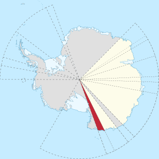
Oates Land is a region of Antarctica. It is variously defined as a portion of the East Antarctica near the coast stretching along and inland from the Oates Coast and as an officially delineated wedge-shaped segment of the Australian Antarctic Territory. The segment of the Australian claim extends between 153°45' E and 160° E, forming a wedge between Latitude 60° S and the South Pole. It is bounded in the east by the Ross Dependency and overlaps George V Land to the west.

Oates Coast is the portion of the coast of Antarctica between Cape Hudson and Cape Williams. It forms the coast of Oates Land, part of the Australian claim to the Antarctic. The eastern portion of this coast was discovered in February 1911 by Lieutenant Harry Pennell, Royal Navy, commander of the expedition ship Terra Nova during the British Antarctic Expedition, 1910–13. He named the coast after Captain Lawrence E.G. Oates who, with Captain Robert F. Scott and three British Antarctic Expedition companions, perished on the return journey from the South Pole in 1912. Captain Oates' death was described by Robert Falcon Scott as "the act of a brave man and English gentleman". The western portion of the coast, the vicinity of the Mawson Peninsula, was first delineated from air photos taken by U.S. Navy Operation Highjump, 1946–47.
Zykov Glacier is a valley glacier about 25 nautical miles long in the Anare Mountains of Victoria Land, Antarctica. It flows northwest and reaches the coast between Cape Williams and Cooper Bluffs. It was photographed by the Soviet Antarctic Expedition (SovAE) in 1958 and named for student navigator Ye. Zykov, who died in Antarctica, Feb. 3, 1957.
The Scott Glacier is a major glacier, 120 nautical miles long, that drains the East Antarctic Ice Sheet through the Queen Maud Mountains to the Ross Ice Shelf. The Scott Glacier is one of a series of major glaciers flowing across the Transantarctic Mountains, with the Amundsen Glacier to the west and the Leverett and Reedy glaciers to the east.

The Danco Coast is the portion of the west coast of the Antarctic Peninsula between Cape Sterneck and Cape Renard. This coast was explored in January and February 1898 by the Belgian Antarctic Expedition under Adrien de Gerlache, who named it for Lieutenant Emile Danco who died on the expedition.
The George VI Ice Shelf is an extensive ice shelf that occupies George VI Sound which separates Alexander Island from Palmer Land in Antarctica. The ice shelf extends from Ronne Entrance, at the southwest end of the sound, to Niznik Island, about 30 nautical miles (56 km) south of the north entrance between Cape Brown and Cape Jeremy. It was named by the UK Antarctic Place-Names Committee in association with George VI Sound.
Beascochea Bay is a bay, 10 nautical miles (19 km) long and 5 nautical miles (9 km) wide, indenting the Graham Coast of Graham Land, Antarctica, between Kyiv Peninsula and Barison Peninsula, and entered south of Cape Perez. The glaciers Lever, Funk, Cadman, Talev and Butamya feed the bay.
McClary Glacier is a glacier 10 nautical miles (19 km) long and 2 nautical miles (4 km) wide on the west coast of Graham Land, Antarctica. It flows southwest along the north side of Butson Ridge into Marguerite Bay between Cape Calmette and the Debenham Islands. The glacier was first roughly surveyed by the British Graham Land Expedition, 1936–37, and resurveyed by the Falkland Islands Dependencies Survey, 1946–50. It was named by the UK Antarctic Place-Names Committee for George B. McClary, father of Nelson McClary, mate on the Port of Beaumont during the Ronne Antarctic Research Expedition, 1947–48.
References
- ↑ Stanton, William (1975). The Great United States Exploring Expedition . Berkeley: University of California Press. pp. 157. ISBN 0520025571.
- ↑ "George V Coast". Geographic Names Information System . United States Geological Survey, United States Department of the Interior . Retrieved 2012-04-22.
![]() This article incorporates public domain material from "George V Coast". Geographic Names Information System . United States Geological Survey.
This article incorporates public domain material from "George V Coast". Geographic Names Information System . United States Geological Survey.
| | This George V Land location article is a stub. You can help Wikipedia by expanding it. |