A gurdwara is a place of assembly and worship for Sikhs. Sikhs also refer to gurdwaras as Gurdwara Sahib. People from all faiths are welcomed in gurdwaras. Each gurdwara has a Darbar Sahib where the Guru Granth Sahib is placed on a takhat in a prominent central position. Any congregant may recite, sing, and explain the verses from the Guru Granth Sahib, in the presence of the rest of the congregation.

Una district is a district in the Indian state of Himachal Pradesh. Una shares its border with the Hoshiarpur and Rupnagar districts of Punjab and Kangra, Hamirpur, and Bilaspur districts of Himachal Pradesh. The terrain is generally plain with semi hills.

Anandpur Sahib, sometimes referred to simply as Anandpur, is a city in Rupnagar district (Ropar), on the edge of Shivalik Hills, in the Indian state of Punjab. Located near the Sutlej River, the city is one of the most sacred places in Sikhism, being the place where the last two Sikh Gurus, Guru Tegh Bahadur and Guru Gobind Singh, lived. It is also the place where Guru Gobind Singh founded the Khalsa Panth in 1699. The city is home to Takhat Sri Kesgarh Sahib, Third of the five Takhts in Sikhism.

Patiala district is one of the twenty three districts in the state of Punjab in north-west India.

Rupnagar is a city and a municipal council in Rupnagar district in the Indian state of Punjab. Rupnagar is a newly created fifth Divisional Headquarters of Punjab comprising Rupnagar, Mohali, and its adjoining districts. It is also one of the bigger sites belonging to the Indus Valley civilization. Rupnagar is nearly 43 km (27 mi) to the northwest of Chandigarh. It is bordered by Himachal Pradesh to the north and Shahid Bhagat Singh Nagar district to its west.

Chamkaur Sahib is a Sub Divisional town in the district of Rupnagar in the Indian State of Punjab. It is famous for the First Battle of Chamkaur (1702) and the Second Battle of Chamkaur (1704) fought between the Mughals and Guru Gobind Singh.

Dadhi is a small village in Rupnagar district, Punjab, India, near the towns of Rupnagar city, Kiratpur Sahib and Anandpur Sahib. The village is situated on the bank of the Sutlej river about 10 km (6.2 mi) south of Anandpur, 30 km (19 mi) north of Rupnagar and 90 km (56 mi) from Chandigarh on the Nangal-Rupnagar-Chandigarh road.

Rupnagar district is one of twenty-two districts in the state of Punjab, India. The city of Rupnagar is said to have been founded by a Raja called Rokeshar, who ruled during the 11th century and named it after his son Rup Sen. It is also the site of an ancient town of the Indus Valley civilization. The major cities in Rupnagar District are Morinda, Nangal and Anandpur Sahib. Morinda is also known as Baghwāla "[The City] of Gardens." Morinda is located on the Chandigarh-Ludhiana Highway. The Bhakra Dam in Nangal lies on the boundary with the neighboring state of Himachal Pradesh. Dadhi is one of the most important villages of the district, particularly because of Gurudwara Sri Hargobindsar Sahib.
Morinda is a city with Municipal Council, near city of Rupnagar in Rupnagar District in the Indian state of Punjab. Morinda is an old town which is believed to trace its name from Mor Jats. It can be known as Moran and then Morinda.
Tewar, is a village in the Mohali District of the state of Punjab, India. According to the 2011 Census, the population of the village is about 4500. The village is situated about 7-8 kilometers east on Kharar-Kurali stretch of NH 21. The village is said to be most developed and bigger than other villages in the area. Tewar is the market hub among the neighboring villages viz. Radiala, Jakar Majra, Bhajauli, Ghataur, Palheri, Rurkee kham, Abheypur etc.. Its market comprises medical stores, apparel stores, electronic stores, electrical stores and general stores. The village has one government sr sec school and 3 private schools and also one computer center. The village has one gramin bank, post office and a verka milk dairy. The village has rich religious places: 1 historical gurudwara sahib named GURUDWARA BHANDARA SAHIB which has religious beliefs that Guru Gobind Singh ji visited that place where gurudwara sahib is built. Village has 2 more gurudwara and 3 Hindu temples and a mosque.

Sikh architecture is a style of architecture that was developed under the Sikh Confederacy and Sikh Empire during the 18th and 19th centuries in the Punjab region. Due to its progressive style, it is constantly evolving into many newly developing branches with new contemporary styles. Although Sikh architecture was initially developed within Sikhism its style has been used in many non-religious buildings due to its beauty. 300 years ago, Sikh architecture was distinguished for its many curves and straight lines; Keshgarh Sahib and the Harmandir Sahib are prime examples.

Puadh is a historic region in north India that comprises parts of present-day Punjab, Haryana, Uttar Pradesh, Himachal Pradesh and the U.T. of Chandigarh, India. It has the Sutlej river in its north and covers the regions immediately south of the Ghaggar river. The people of the area are known as Puadhi and speak the Puadhi dialect of Punjabi. The capital cities of Puadh region are Rupnagar, Fatehgarh Sahib, Mohali, Patiala, Chandigarh, Panchkula, Ambala, Yamunanagar

Puadhi is a dialect of Punjabi primarily spoken in the Puadh region of northern India. It is spoken between the Sutlej and Ghaggar river basins in the present day states of Punjab and Haryana, and the union territory of Chandigarh and Uttar Pradesh
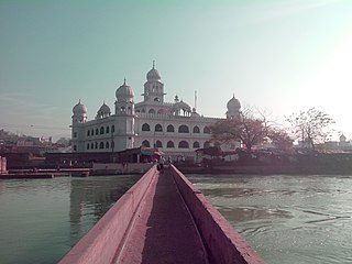
Kiratpur also known as Kiratpur Sahib is a town in Rupnagar district, Punjab, India. The town is the location of the Gurdwara Patal Puri where many Sikhs take ashes of their deceased.
National Highway 205 commonly referred to as NH 205, is a highway in India. The highway passes through the Indian states of Himachal Pradesh and Punjab.
Chamkaur Sahib Assembly constituency is one of the 117 constituencies of the Punjab Legislative Assembly in the state of Punjab, India. It lies in Rupnagar district and is reserved for member of the Scheduled Castes.
Sotran is a village in Shaheed Bhagat Singh Nagar district of Punjab State, India. It is located 9.2 kilometres (5.7 mi) away Mukandpur, 1.8 kilometres (1.1 mi) from Banga, 12 kilometres (7.5 mi) from district headquarters Shaheed Bhagat Singh Nagar and 105 kilometres (65 mi) from the state capital Chandigarh. The village is administrated by Sarpanch an elected representative of the village.
Nangal Dam Ambala Passenger is a Passenger express train of the Indian Railways connecting Ambala Cantonment Junction in Haryana and Nangal Dam in Punjab. It is currently being operated with 64514/64515 train numbers on daily basis.
Rupnagar railway station is a railway station in Rupnagar district, Punjab. Its code is RPAR. It is fall under Northern Railway zone's Ambala railway division. It serves Rupnagar city. The station consists of 1 platform.

