
Gilbert's Coombe is a hamlet north of Redruth in west Cornwall, England. [1] It falls within the Redruth North division on Cornwall Council. [2]
Gilbert's Coombe is a hamlet north of Redruth in west Cornwall, England. [1] It falls within the Redruth North division on Cornwall Council. [2]

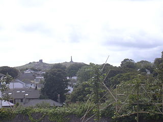
Redruth is a town and civil parish in Cornwall, England. The population of Redruth was 14,018 at the 2011 census. In the same year the population of the Camborne-Redruth urban area, which also includes Carn Brea, Illogan and several satellite villages, stood at 55,400 making it the largest conurbation in Cornwall. Redruth lies approximately at the junction of the A393 and A3047 roads, on the route of the old London to Land's End trunk road, and is approximately 9 miles (14 km) west of Truro, 12 miles (19 km) east of St Ives, 18 miles (29 km) north east of Penzance and 11 miles (18 km) north west of Falmouth. Camborne and Redruth together form the largest urban area in Cornwall and before local government reorganisation were an urban district.
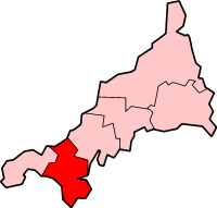
Kerrier was a local government district in Cornwall, England, United Kingdom. It was the most southerly district in the United Kingdom, other than the Isles of Scilly. Its council was based in Camborne. Other towns in the district included Redruth and Helston. The district also contained the Lizard Peninsula.
Carn Brea is a civil parish and hilltop site in Cornwall, England, United Kingdom. The population of Carn Brea including Bosleake and Church Coombe was 8,013 at the 2011 census. The hilltop site is situated approximately one mile (1.6 km) southwest of Redruth. The settlements of Bosleake, Brea, Broad Lane, Carn Arthen, Carn Brea Village, Carnkie, Four Lanes, Grillis, Illogan Highway, Pencoys, Penhallick, Piece, Pool, Tolskithy, Tregajorran, Treskillard, Tuckingmill and West Tolgus are in the parish.
There are three Redruth transmitting stations:

Falmouth and Camborne was, from 1950 until 2010, a county constituency represented in the House of Commons of the Parliament of the United Kingdom. It elected one Member of Parliament (MP) by the first past the post system of election.
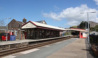
Redruth station serves the town of Redruth, Cornwall, United Kingdom, and is situated on the Cornish Main Line between Truro and Camborne. The station is 310 miles (500 km) from London Paddington via Bristol Temple Meads.
Camborne-Redruth was an urban district in Cornwall, England, from 1934 to 1974. It was formed as a merger of Camborne and Redruth urban districts along with parts of Redruth Rural District and Helston Rural District. The towns are about four miles apart and form a loose conurbation.

Camborne and Redruth is a parliamentary constituency in the United Kingdom. The seat is in Cornwall on the South West Peninsula of England, and is currently represented by George Eustice, a Conservative who served as Environment Secretary between 2020 and 2022.
Pool is a village in Carn Brea civil parish in west Cornwall, England. It is bypassed by the A30, on the A3047 between Camborne and Redruth, between Tuckingmill and Illogan Highway.

Redruth Grammar School in Redruth, Cornwall, was a boys school between 1907 and 1976.

Four Lanes is a village in west Cornwall, England, United Kingdom approximately 3 miles (4.8 km) south of Redruth at grid reference SW 689 386 in the civil parish of Carn Brea.

Blowinghouse is the name of two settlements in Cornwall, England, United Kingdom.

Chiverton Cross is a road junction in west Cornwall, England, United Kingdom, about four miles north-east of Redruth and five miles (8 km) west of Truro at OS grid ref SW747469. Its name derives from Chyverton House which is in the extreme east of the parish of Perranzabuloe.

Menagissey is a hamlet in Cornwall, England, United Kingdom. It is half-a-mile south of Mount Hawke about three miles (5 km) north-northeast of Redruth in the civil parish of St Agnes. It is included in the Mount Hawke and Portreath division on Cornwall Council.

Restronguet Creek is a tidal ria in south Cornwall, United Kingdom. It is a tributary of Carrick Roads, the estuary of the River Fal, and is situated approximately four miles (6.5 km) south of Truro and three miles (5 km) north of Falmouth.

Chycoose, Point and Penpol form a coastal settlement around Penpol Creek in Cornwall, England, United Kingdom.

Trehan is a hamlet near Saltash in Cornwall, England, United Kingdom.

Treleigh is a hamlet north of Redruth in Cornwall, England, United Kingdom.

Kresen Kernow in Redruth, United Kingdom is Cornwall's archive centre, home to the world's biggest collection of archive and library material related to Cornwall. Funded by the National Lottery Heritage Fund and Cornwall Council and opened in 2019, it brings together the collections which were previously held at Cornwall Record Office, the Cornish Studies Library and Cornwall and Scilly Historic Environment Record as well as in various outstores.
Redruth North is an electoral division of Cornwall in the United Kingdom and returns one member to sit on Cornwall Council. The current Councillor is Stephen Barnes, the leader of the Labour Party on the Council.
| Unitary authorities | |
|---|---|
| Major settlements |
|
| Rivers | |
| Topics | |
Coordinates: 50°14′50″N5°14′26″W / 50.24722°N 5.24056°W
| | This Cornwall location article is a stub. You can help Wikipedia by expanding it. |