Glen Arbor, Michigan

Last updated
Glen Arbor, Michigan
Sylvan Inn-Glen Arbor.jpg
The Sylvan Inn, founded in 1885
Glen Arbor, MI location.png
Location within Leelanau County
USA Michigan location map.svg
Red pog.svg
Glen Arbor
Location within the state of Michigan
Usa edcp location map.svg
Red pog.svg
Glen Arbor
Location within the United States
Coordinates: 44°53′51″N85°59′07″W / 44.89750°N 85.98528°W / 44.89750; -85.98528 Coordinates: 44°53′51″N85°59′07″W / 44.89750°N 85.98528°W / 44.89750; -85.98528
CountryFlag of the United States.svg United States
State Flag of Michigan.svg  Michigan
County Flag of Leelanau County, Michigan.svg Leelanau
Township Glen Arbor
Area
[1]
  Total1.04 sq mi (2.71 km2)
  Land1.03 sq mi (2.66 km2)
  Water0.02 sq mi (0.04 km2)
Elevation
591 ft (180 m)
Population
 (2020)
  Total261
  Density253.64/sq mi (97.95/km2)
Time zone UTC-5 (Eastern (EST))
  Summer (DST) UTC-4 (EDT)
ZIP code(s)
49636
Area code 231
GNIS feature ID626870 [2]

Glen Arbor is an unincorporated community and census-designated place in Glen Arbor Township, Leelanau County, Michigan, United States. A small tourist town, Glen Arbor lies on an isthmus between Lake Michigan and Glen Lake. It is adjacent to Sleeping Bear Dunes National Lakeshore.

Contents

Its population was 261 as of the 2020 census, up from 229 at the 2010 census. [3] The community is located along M-22 and the Lake Michigan shore. Glen Arbor has a post office with ZIP code 49636. [4] [5]

History

The land around Glen Arbor was first inhabited by Odawa, Ojibwe, and Potawatomi peoples, all members of the Council of Three Fires.

By 1886, lumberman D.H. Day bought vast swathes of land north of Glen Lake. He had built a sawmill on the nearby Crystal River, and developed the nearby town of Glen Haven, which led to the growth of Glen Arbor. By the 1900s, the area was recognized as a tourist mecca. [6] In 1971, much of Day's former land was converted to Sleeping Bear Dunes National Lakeshore. [7]

Etymology

Glen Arbor's name was coined by the wife of one of the area's early settlers. It is a combination of Glen Lake and grapevines that adorned trees in the area. [6]

Geography

According to the U.S. Census Bureau, the community has an area of 1.044 square miles (2.70 km2), of which 1.028 square miles (2.66 km2) is land and 0.016 square miles (0.041 km2) is water. [3]

Glen Arbor is bordered to the south by the shores of Glen Lake, to the west by the Sleeping Bear Dunes National Lakeshore, and to the north by Lake Michigan. Meandering to the east of the town, the Crystal River intersects many roads and hiking trails before terminating in Lake Michigan.

Major highways

Demographics

Historical population
CensusPop.
2010 229
2020 26114.0%
U.S. Decennial Census [8]

As of the census [9] of 2010, there were 229 people living in the township. The population density was 27.6 inhabitants per square mile (10.7/km2). There were 1,617 housing units at an average density of 56.6 per square mile (21.9/km2). The racial makeup of the township was 98.69% White, 0.44% African American, 0.44% Asian, and 0.44% from two or more races. Hispanic or Latino of any race were 1.31% of the population.

The gender gap of the town was almost split evenly, with females accounting for 53.71% and males for 46.29% of the population.

In the township the population was spread out, with 11.79% under the age of 18, 45.85% from 18 to 64, and 42.36% who were 65 years of age or older. The median age was 53 years. For every 100 females, there were 96.0 males. For every 100 females age 18 and over, there were 97.0 males.

The median income for a household in the township was $46,719, and the median income for a family was $58,571. Males had a median income of $35,114 versus $30,179 for females. The per capita income for the township was $29,070. About 1.5% of families and 5.1% of the population were below the poverty line, including 6.0% of those under age 18 and 2.0% of those age 65 or over.

Related Research Articles

<span class="mw-page-title-main">Leelanau County, Michigan</span> County in Michigan, United States

Leelanau County is a county located in the U.S. state of Michigan. As of the 2020 Census, the population was 22,301. Since 2008, the county seat has been located within Suttons Bay Township, one mile east of the unincorporated village of Lake Leelanau. Before 2008, Leelanau County's seat was Leland. Leelanau County is included in the Traverse City Micropolitan Statistical Area of Northern Michigan. The largest settlement in Leelanau County by population is Greilickville, itself a suburb of Traverse City.

<span class="mw-page-title-main">Benzie County, Michigan</span> County in Michigan, United States

Benzie County is a county in the U.S. state of Michigan. As of the 2020 Census, the population was 17,970. The county seat is Beulah. The county was initially set off in 1863 and organized in 1869. At 321 square miles (831 km2), Benzie County is the smallest of the 83 counties in Michigan in terms of land area.

<span class="mw-page-title-main">Inland Township, Michigan</span> Civil township in Michigan, United States

Inland Township is a civil township of Benzie County in the U.S. state of Michigan. The population was 2,386 at the 2020 census. The township is located in the east of the county, and shares a border with Grand Traverse County. The Platte River flows through the north of the township.

<span class="mw-page-title-main">Lake Township, Benzie County, Michigan</span> Civil township in Michigan, United States

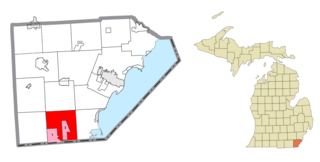
Lake Township is a civil township of Benzie County in the U.S. state of Michigan. The population was 694 at the 2020 census. The township is irregularly shaped, following the shore of Lake Michigan from Crystal Lake north to the border with Leelanau County. A portion of the Sleeping Bear Dunes National Lakeshore is located in the northern end of the township.

<span class="mw-page-title-main">Lake Charter Township, Michigan</span> Charter township in Michigan, United States

Lake Charter Township is a charter township of Berrien County in the U.S. state of Michigan. The population was 2,972 at the 2010 census.

<span class="mw-page-title-main">Shorewood–Tower Hills–Harbert, Michigan</span> Census-designated place & unincorporated communities in Michigan, United States

Shorewood–Tower Hills–Harbert is a census-designated place (CDP) composed of several small unincorporated communities in Chikaming Township of Berrien County in the U.S. state of Michigan. The population was 1,249 at the 2020 census. The median age is 60.5, but the township has a large youth population as well. The CDP is limited to Chikaming Township, although some of the communities extend into southern Lake Township. All of the communities are located either upon or just east of the dunes on the shore of Lake Michigan. Most of the communities lie west of Interstate 94, although the CDP includes a small area east of the freeway up to Sawyer. In the town, white females make a disproportionately low amount of income. The township is a popular resort destination.

<span class="mw-page-title-main">Cleveland Township, Michigan</span> Civil township in Michigan, United States

Cleveland Township is a civil township of Leelanau County in the U.S. state of Michigan. The population of Cleveland Township was 1,103 at the 2020 census. Part of the township is located within Sleeping Bear Dunes National Lakeshore.

<span class="mw-page-title-main">Empire, Michigan</span> Village in Michigan, United States

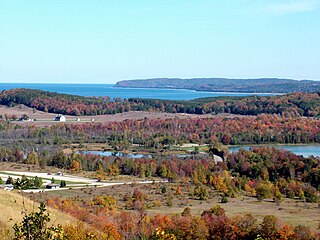
Empire is a village on Lake Michigan in the northwestern Lower Peninsula of Michigan. Located in southwestern Leelanau County, its population was 362 at the 2020 census. The village is located within Empire Township, and is famous for its proximity to the Sleeping Bear Dunes National Lakeshore. Empire is home to the lakeshore's headquarters, the Philip A. Hart Visitor Center.

<span class="mw-page-title-main">Empire Township, Michigan</span> Civil township in Michigan, United States

Empire Township is a civil township of Leelanau County in the U.S. state of Michigan. The population was 764 at the 2020 census. On the shores of Lake Michigan, Empire Township contains a substantial amount of land within the Sleeping Bear Dunes National Lakeshore.

<span class="mw-page-title-main">Glen Arbor Township, Michigan</span> Civil township in Michigan, United States

Glen Arbor Township is a civil township of Leelanau County in the U.S. state of Michigan. The population was 757 at the 2020 census. However, the population of the town expands rapidly during the summer months as a result of it being a summer colony.

<span class="mw-page-title-main">Kasson Township, Michigan</span> Civil township in Michigan, United States

Kasson Township is a civil township of Leelanau County in the U.S. state of Michigan. The population was 1,647 as of the 2020 census. A small portion of the township is included in the Sleeping Bear Dunes National Lakeshore.
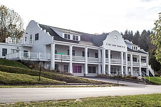
<span class="mw-page-title-main">Hamburg Township, Michigan</span> Civil township in Michigan, United States

Hamburg Township is a civil township of Livingston County in the U.S. state of Michigan. As of the 2010 census, the township population was 21,165. It is the most populated municipality in Livingston County.

Marilla Township is a civil township of Manistee County in the U.S. state of Michigan. The population was 362 at the 2000 census.

<span class="mw-page-title-main">Onekama Township, Michigan</span> Township in Michigan, United States

Onekama Township is a civil township of Manistee County in the U.S. state of Michigan. The population was 1,514 at the 2000 census.

Belvidere Township is a civil township of Montcalm County in the U.S. state of Michigan. As of the 2000 census, the township population was 2,438.

Golden Township is a civil township of Oceana County in the U.S. state of Michigan. The population was 1,810 at the 2000 census.

<span class="mw-page-title-main">Lyon Township, Roscommon County, Michigan</span> Civil township in Michigan, United States

Lyon Township is a civil township of Roscommon County in the U.S. state of Michigan. The population was 1,370 at the 2010 census.

<span class="mw-page-title-main">Pine Grove Township, Michigan</span> Township in Michigan, United States

Pine Grove Township is a civil township of Van Buren County in the U.S. state of Michigan. The population was 2,773 at the 2000 census.

<span class="mw-page-title-main">Whitmore Lake, Michigan</span> Census-designated place & unincorporated community in Michigan, United States

Whitmore Lake is a census-designated place (CDP) and unincorporated community in the U.S. state of Michigan. The community spans the boundary between Green Oak Township in Livingston County and Northfield Township in Washtenaw County. The population of the CDP was 7,584 at the 2020 census.

Maple Valley Township is a civil township of Montcalm County in the U.S. state of Michigan. The population was 2,083 at the 2000 census.

References

  1. "2020 U.S. Gazetteer Files". United States Census Bureau. Retrieved May 21, 2022.
  2. "Glen Arbor". Geographic Names Information System . United States Geological Survey, United States Department of the Interior.
  3. 1 2 "2010 Census Gazetteer Files - Places: Michigan". U.S. Census Bureau . Retrieved May 6, 2018.
  4. United States Postal Service. "USPS - Look Up a ZIP Code" . Retrieved May 6, 2018.
  5. "Postmaster Finder - Post Offices by ZIP Code". United States Postal Service . Retrieved May 6, 2018.
  6. 1 2 "History". Glen Lake Chamber of Commerce. Retrieved 2022-11-02.
  7. Kalt, Brian (2001). Sixties Sandstorm: The Fight Over Establishment of a Sleeping Bear Dunes National Lakeshore, 1961–1970. East Lansing: Michigan State University Press. ISBN   9780870135590.[ page needed ]
  8. "Census of Population and Housing". Census.gov. Retrieved June 4, 2016.
  9. "U.S. Census website". United States Census Bureau . Retrieved 2008-01-31.