
A glen is a valley, typically one that is long and bounded by gently sloped concave sides, unlike a ravine, which is deep and bounded by steep slopes. Whittow defines it as a "Scottish term for a deep valley in the Highlands" that is "narrower than a strath". The word is Goidelic in origin: gleann in Irish and Scottish Gaelic, glion in Manx. The designation "glen" also occurs often in place names.

The Lagan Valley is an area of Northern Ireland between Belfast and Lisburn. The River Lagan rises on Slieve Croob in County Down and flows generally northward discharging into Belfast Lough. For a section, the river forms part of the border between the counties of Antrim and Down.

The Glens of Antrim, known locally as simply The Glens, is a region of County Antrim, Northern Ireland. It comprises nine glens (valleys), that radiate from the Antrim Plateau to the coast. The Glens are an area of outstanding natural beauty and are a major tourist attraction in north Antrim.

The A2 is a major road in Northern Ireland, a considerable length of which is often referred to the Antrim Coast Road because much of it follows the scenic coastline of County Antrim; other parts of the road follow the coasts in Counties Down and Londonderry.
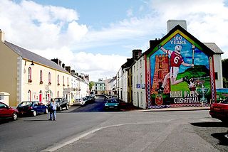
Cushendall, formerly known as Newtownglens, is a coastal village and townland in County Antrim, Northern Ireland. It is located in the historic barony of Glenarm Lower and the civil parish of Layd, and is part of Causeway Coast and Glens district.

Portballintrae is a small seaside village in County Antrim, Northern Ireland. It is four miles east of Portrush and two miles west of the Giant's Causeway. In the 2001 Census it had a population of 734 people, a decline of 10% compared to 1991. It lies within the Causeway Coast and Glens District Council area.

Waterfoot or Glenariff is a small coastal village in County Antrim, Northern Ireland. It is at the foot of Glenariff, one of the Glens of Antrim, within the historic barony of Glenarm Lower and the civil parishes of Ardclinis and Layd. The village is in the townland of Warren. The 2001 Census recorded a population of 504 inhabitants.

Glenoe or Gleno is a hamlet in County Antrim, Northern Ireland. It is halfway between Larne and Carrickfergus. In the 2001 Census, it had a population of 87 people. Glenoe is in the Mid and East Antrim Borough Council area.
Ballyvoy is a small village and townland in County Antrim, Northern Ireland. It is on the main A2 coast road 5 km east of Ballycastle and 17 km north west of Cushendall. In the 2001 Census it had a population of 72 people. It lies within the Antrim Coast and Glens Area of Outstanding Natural Beauty and is part of Causeway Coast and Glens District Council.

Moss-side or Mosside is a small village and townland in County Antrim, Northern Ireland. In the 2001 Census it had a population of 270 people.

Glendun translates into English as glen of the brown river and is one of the nine Glens of Antrim in County Antrim in Northern Ireland.
Glenariff Forest Park is an 1185 hectare forest in County Antrim, Northern Ireland. It is part of Glenariff glen itself. The forest is managed by the Northern Ireland Forest Service, the state body responsible for forestry in the province, which is part of the Department of Agriculture, Environment and Rural Affairs.

Lagan Valley is a constituency in the Northern Ireland Assembly.
The Ballymena, Cushendall and Red Bay Railway was a 3 ft narrow gauge railway between Ballymena and Retreat, both in County Antrim, in what is now Northern Ireland. It operated from 1875 to 1940.

Glenshesk is one of the nine Glens of Antrim in County Antrim, Northern Ireland. It was shaped by glacial erosion. The glen lies on the eastern side of Knocklayde mountain and flows out to the sea at Ballycastle.

Red Bay Castle is situated in County Antrim, Northern Ireland, on a headland projecting into the sea north of Glenariff situated on the road to Cushendall.
Glenviggan is a townland in County Londonderry, Northern Ireland with a population of 43 people. In 1911, the population was 77.
The Glenariff Iron Ore and Harbour Company (GIOH) was a railway and harbour company in Glenariff, County Antrim, in what is now Northern Ireland. It operated Red Bay Pier on the Antrim coast and about 4 miles (6.4 km) of narrow gauge railway between the pier and Cloughcor Mines in Glenariff. The railway was 3 ft narrow gauge and carried iron ore from the mines to the pier, where it was loaded onto cargo ships for export to ironworks in Scotland and England.
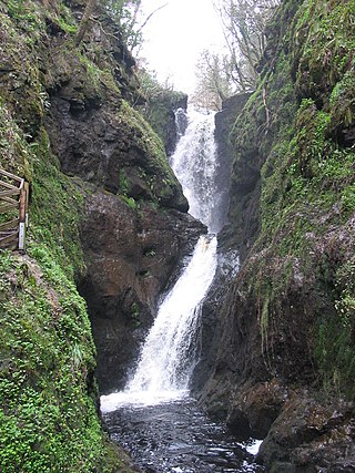
Ess na Larach is a waterfall in Glenariff Forest Park, County Antrim, Northern Ireland. It lies along Glenariff River.

