Train station in Gondiswil. The first railroad station in the village was built in 1889.Aerial view of Gondiswil, Ärbolligen and Rohrbach from 3000m by Walter Mittelholzer (1923)
Gondiswil is first mentioned in the mid-9th century as Cundolteswilare.[3]
Religiously it was part of the parish of Grossdietwil in Lucerne until the Protestant Reformation. In 1528 it became part of the parish of Melchnau. In an effort to become their own parish, in 1737 the village built a cemetery. However, it took several centuries for this goal to be realized. Starting in 1856 or 1870 worship and Sunday school services were conducted in the village. In 1918 a church was completed. Then, in 1945 the Melchnau parish appointed a vicar to oversee Gondiswil. Finally in 1960, a rectory was built and the village became a parish. In 1300 in the hamlet of Freibach, the Lords of Büttikon built St. Mary's Chapel. During the 14th and 15th centuries, this chapel became a pilgrimage site and the headquarters of a regional blacksmiths fellowship. The chapel was demolished in 1528.[3]
During the 18th and 19th centuries, linen mills and a wooden shoe factory provided jobs outside of agriculture. In 1889 the Langenthal-Huttwil-Wolhusenbahn built a railroad and station through Gondiswil. During the First and Second World Wars there was a coal mine in the village.[3]
Geography
Farm house and fields outside Gondiswil
Gondiswil has an area of 9.4km2 (3.63sqmi).[4] Of this area, 6.49km2 (2.51sqmi) or 69.3% is used for agricultural purposes, while 2.28km2 (0.88sqmi) or 24.3% is forested. Of the rest of the land, 0.55km2 (0.21sqmi) or 5.9% is settled (buildings or roads), 0.03km2 (7.4 acres) or 0.3% is either rivers or lakes and 0.01km2 (2.5 acres) or 0.1% is unproductive land.[5]
Of the built up area, housing and buildings made up 2.3% and transportation infrastructure made up 3.0%. Out of the forested land, all of the forested land area is covered with heavy forests. Of the agricultural land, 40.4% is used for growing crops and 26.6% is pastures, while 2.2% is used for orchards or vine crops. All the water in the municipality is flowing water.[5]
The municipality is located on the border with the Canton of Lucerne. It consists of the village of Gondiswil and the hamlets of Freibach, Brüggenweid, Haltstelle, Staldershaus and Schwendi.
On 31 December 2009 Amtsbezirk Aarwangen, the municipality's former district, was dissolved. On the following day, 1 January 2010, it joined the newly created Verwaltungskreis Oberaargau.[6]
Coat of arms
The blazon of the municipal coat of arms is Azure a Trefoil issuant from a Mount of 3 Coupeaux Vert and in Chief two Mullets of Five Argent.[7]
Demographics
Gondiswil village center
Gondiswil has a population (as of December 2020[update]) of 711.[8]As of 2010[update], 2.0% of the population are resident foreign nationals.[9] Over the last 10 years (2000-2010) the population has changed at a rate of -4.5%. Migration accounted for -2.8%, while births and deaths accounted for -2.3%.[10]
Most of the population (as of 2000[update]) speaks German (715 or 97.4%) as their first language, Albanian is the second most common (13 or 1.8%) and English is the third (3 or 0.4%). There is 1 person who speaks French and 1 person who speaks Romansh.[11]
As of 2008[update], the population was 51.0% male and 49.0% female. The population was made up of 354 Swiss men (49.9% of the population) and 8 (1.1%) non-Swiss men. There were 342 Swiss women (48.2%) and 6 (0.8%) non-Swiss women.[9] Of the population in the municipality, 374 or about 51.0% were born in Gondiswil and lived there in 2000. There were 235 or 32.0% who were born in the same canton, while 78 or 10.6% were born somewhere else in Switzerland, and 29 or 4.0% were born outside of Switzerland.[11]
As of 2010[update], children and teenagers (0–19 years old) make up 20.8% of the population, while adults (20–64 years old) make up 58% and seniors (over 64 years old) make up 21.1%.[10]
As of 2000[update], there were 298 people who were single and never married in the municipality. There were 370 married individuals, 43 widows or widowers and 23 individuals who are divorced.[11]
As of 2000[update], there were 72 households that consist of only one person and 28 households with five or more people. In 2000[update], a total of 279 apartments (87.7% of the total) were permanently occupied, while 15 apartments (4.7%) were seasonally occupied and 24 apartments (7.5%) were empty.[12]As of 2010[update], the construction rate of new housing units was 1.4 new units per 1000 residents.[10] The vacancy rate for the municipality, in 2011[update], was 2.8%.
The historical population is given in the following chart:[3][13]
Transportation
Gondiswil train station
Gondiswil lies on the Wolhusen–Huttwil railway and has a station.
Politics
In the 2011 federal election the most popular party was the SVP which received 48.3% of the vote. The next three most popular parties were the BDP Party (17.9%), the SPS (8.3%) and the FDP (5.7%). In the federal election, a total of 300 votes were cast, and the voter turnout was 50.2%.[14]
Economy
In 1894 the Schieferkohle railway was founded. From 1918 to 1919, limited coal mining occurred, but the beds were too small, and the mine collapsed, leaving a small lake. In World War II, coal was again mined from the area.
As of 2011[update], Gondiswil had an unemployment rate of 0.44%. As of 2008[update], there were a total of 228 people employed in the municipality. Of these, there were 135 people employed in the primary economic sector and about 51 businesses involved in this sector. 58 people were employed in the secondary sector and there were 10 businesses in this sector. 35 people were employed in the tertiary sector, with 13 businesses in this sector.[10]
In 2008[update] there were a total of 158 full-time equivalent jobs. The number of jobs in the primary sector was 79, all of which were in agriculture. The number of jobs in the secondary sector was 51 of which 39 or (76.5%) were in manufacturing and 12 (23.5%) were in construction. The number of jobs in the tertiary sector was 28. In the tertiary sector; 8 or 28.6% were in wholesale or retail sales or the repair of motor vehicles, 4 or 14.3% were in a hotel or restaurant and 8 or 28.6% were in education.[15]
In 2000[update], there were 48 workers who commuted into the municipality and 238 workers who commuted away. The municipality is a net exporter of workers, with about 5.0 workers leaving the municipality for every one entering.[16] Of the working population, 7% used public transportation to get to work, and 58.2% used a private car.[10]
Religion
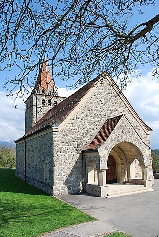
Reformed church, post office and town hall
From the 2000 census[update], 40 or 5.4% were Roman Catholic, while 645 or 87.9% belonged to the Swiss Reformed Church. Of the rest of the population, there were 2 members of an Orthodox church (or about 0.27% of the population), and there were 11 individuals (or about 1.50% of the population) who belonged to another Christian church. There were 6 (or about 0.82% of the population) who were Islamic. 18 (or about 2.45% of the population) belonged to no church, are agnostic or atheist, and 17 individuals (or about 2.32% of the population) did not answer the question.[11]
Education
In Gondiswil about 294 or (40.1%) of the population have completed non-mandatory upper secondary education, and 58 or (7.9%) have completed additional higher education (either university or a Fachhochschule). Of the 58 who completed tertiary schooling, 75.9% were Swiss men, 19.0% were Swiss women.[11]
The Canton of Bern school system provides one year of non-obligatory Kindergarten, followed by six years of Primary school. This is followed by three years of obligatory lower Secondary school where the students are separated according to ability and aptitude. Following the lower Secondary students may attend additional schooling or they may enter an apprenticeship.[17]
During the 2009–10 school year, there were a total of 67 students attending classes in Gondiswil. There were no kindergarten classes in the municipality. The municipality had 3 primary classes and 52 students. Of the primary students, 3.8% were permanent or temporary residents of Switzerland (not citizens) and 1.9% have a different mother language than the classroom language. During the same year, there was one lower secondary class with a total of 15 students. There were 6.7% who were permanent or temporary residents of Switzerland (not citizens) and 6.7% have a different mother language than the classroom language.[18]
As of 2000[update], there were 9 students in Gondiswil who came from another municipality, while 25 residents attended schools outside the municipality.[16]
Related Research Articles
Courtételle is a municipality in the district of Delémont in the canton of Jura in Switzerland.
Aarwangen is a village and a municipality in the Oberaargau administrative district in the canton of Bern in Switzerland.
Develier is a municipality in the district of Delémont in the canton of Jura in Switzerland.
La Chaux-des-Breuleux is a former municipality in the district of Franches-Montagnes in the canton of Jura in Switzerland. On 1 January 2023 the former municipality of La Chaux-des-Breuleux merged to form the municipality of Les Breuleux.
Pleigne is a municipality in the district of Delémont in the canton of Jura in Switzerland.
Morlon is a municipality in the district of Gruyère in the canton of Fribourg in Switzerland.
Bannwil is a municipality in the Oberaargau administrative district in the canton of Bern in Switzerland.
Busswil bei Melchnau is a municipality in the Oberaargau administrative district in the canton of Bern in Switzerland.
Madiswil is a municipality in the Oberaargau administrative district in the canton of Bern in Switzerland. Since January 1, 2007, Gutenburg is part of the municipality. On 1 January 2011 Kleindietwil and Leimiswil were merged with the municipality of Madiswil.
Melchnau is a municipality in the Oberaargau administrative district in the canton of Bern in Switzerland.
Reisiwil is a municipality in the Oberaargau administrative district in the canton of Bern in Switzerland.
Rohrbachgraben is a municipality in the Oberaargau administrative district in the canton of Bern in Switzerland.
Ursenbach is a municipality in the Oberaargau administrative district in the canton of Bern in Switzerland.
Les Planchettes is a municipality in the canton of Neuchâtel in Switzerland.
Granges, officially referred to as Granges (Veveyse), is a municipality in the district of Veveyse in the canton of Fribourg in Switzerland.
Plasselb is a municipality in the district of Sense in the canton of Fribourg in Switzerland. It is one of the municipalities with a large majority of German speakers in the mostly French speaking Canton of Fribourg.
Tentlingen is a municipality in the district of Sense in the canton of Fribourg in Switzerland. It is one of the municipalities with a large majority of German speakers in the mostly French speaking Canton of Fribourg.
Ueberstorf is a municipality in the district of Sense in the canton of Fribourg, Switzerland. It is one of the municipalities with a large majority of German speaking people in the mostly French speaking Canton of Fribourg.
Ried bei Kerzers is a municipality in the district of See, within the canton of Fribourg, Switzerland. It is one of the municipalities with a large majority of German speakers in the mostly French speaking Canton of Fribourg.
La Sonnaz is a municipality in the district of Sarine in the canton of Fribourg in Switzerland. The municipality was created in 2004 through the merger of Cormagens, La Corbaz and Lossy-Formangueires. The municipal administration, the kindergarten and the primary school are in Lossy.
This page is based on this Wikipedia article Text is available under the CC BY-SA 4.0 license; additional terms may apply. Images, videos and audio are available under their respective licenses.