Grass Lake Township, Kanabec County, Minnesota

Last updated

Grass Lake Township, Minnesota
USA Minnesota location map.svg
Red pog.svg
Grass Lake Township
Location within Minnesota and the United States
Usa edcp location map.svg
Red pog.svg
Grass Lake Township
Grass Lake Township (the United States)
Coordinates: 45°45′58″N93°11′7″W / 45.76611°N 93.18528°W / 45.76611; -93.18528
Country United States
State Minnesota
County Kanabec
Area
  Total34.8 sq mi (90.2 km2)
  Land34.6 sq mi (89.5 km2)
  Water0.3 sq mi (0.7 km2)
Elevation
955 ft (291 m)
Population
 (2000)
  Total928
  Density26.8/sq mi (10.4/km2)
Time zone UTC-6 (Central (CST))
  Summer (DST) UTC-5 (CDT)
FIPS code 27-25406 [1]
GNIS feature ID0664330 [2]

Grass Lake Township is a township in Kanabec County, Minnesota, United States. The population was 928 at the 2000 census.

Contents

Etymology

This township took its name from Grass Lake. [3]

Geography

According to the United States Census Bureau, the township has a total area of 34.8 square miles (90 km2), of which 34.6 square miles (90 km2) is land and 0.3 square miles (0.78 km2) (0.77%) is water.

Demographics

As of the census [1] of 2000, there were 928 people, 340 households, and 263 families residing in the township. The population density was 26.8 inhabitants per square mile (10.3/km2). There were 357 housing units at an average density of 10.3/sq mi (4.0/km2). The racial makeup of the township was 97.41% White, 0.32% African American, 0.54% Native American, 0.11% Asian, and 1.62% from two or more races. Hispanic or Latino of any race were 0.86% of the population.

There were 340 households, out of which 33.5% had children under the age of 18 living with them, 66.2% were married couples living together, 3.8% had a female householder with no husband present, and 22.6% were non-families. 18.5% of all households were made up of individuals, and 4.7% had someone living alone who was 65 years of age or older. The average household size was 2.73 and the average family size was 3.10.

In the township the population was spread out, with 26.8% under the age of 18, 7.8% from 18 to 24, 30.3% from 25 to 44, 24.7% from 45 to 64, and 10.5% who were 65 years of age or older. The median age was 37 years. For every 100 females, there were 111.4 males. For every 100 females age 18 and over, there were 116.9 males.

The median income for a household in the township was $39,083, and the median income for a family was $42,708. Males had a median income of $32,589 versus $21,364 for females. The per capita income for the township was $17,110. About 2.3% of families and 5.7% of the population were below the poverty line, including 7.9% of those under age 18 and 5.9% of those age 65 or over.

Related Research Articles

Waukenabo Township is a township in Aitkin County, Minnesota, United States. The population was 316 as of the 2010 census.

Cottonwood Township is a township in Brown County, Minnesota, United States. The population was 938 as of the 2000 census.

Powers Township is a township in Cass County, Minnesota, United States. The population was 918 at the 2000 census. Powers Township was named for Gorham Powers, a Minnesota politician who owned land there.

Moland Township is a township in Clay County, Minnesota, United States. The population was 340 at the 2000 census.

Hudson Township is a township in Douglas County, Minnesota, United States. The population was 686 at the 2000 census.

Lone Pine Township is a township in Itasca County, Minnesota, United States. The population was 410 at the 2010 census.

Manfred Township is a township in Lac qui Parle County, Minnesota, United States. The population was 111 at the 2000 census.

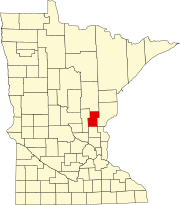
Forest Prairie Township is a township in Meeker County, Minnesota, United States. The population was 869 at the 2000 census.

Harvey Township is a township in Meeker County, Minnesota, United States. The population was 445 at the 2000 census.

Litchfield Township is a township in Meeker County, Minnesota, United States. The population was 808 at the 2000 census. The township includes most of the city of Litchfield, except for a small protrusion northeast into Forest City Township and another small one due east into Darwin Township.

Manannah Township is a township in Meeker County, Minnesota, United States. The population was 610 at the 2000 census. Most of the city of Eden Valley is located in Manannah Township

Swede Grove Township is a township in Meeker County, Minnesota, United States. The population was 414 at the 2000 census.

East Side Township is a township in Mille Lacs County, Minnesota, United States. The population was 620 at the 2010 census.

Pulaski Township is a township in Morrison County, Minnesota, United States. The population was 340 at the 2000 census.

Royalton Township is a township in Pine County, Minnesota, United States. The population was 976 at the 2000 census.

Morristown Township is a township in Rice County, Minnesota, United States. The population was 665 at the 2000 census.

Little Elk Township is a township in Todd County, Minnesota, United States. The population was 340 at the 2000 census and was 266 at the time of the 2020 Census.

Elgin Township is a township in Wabasha County, Minnesota, United States. The population was 787 at the 2000 census.

May Township is a township in Washington County, Minnesota, United States. The population was 2,928 at the 2000 census.

Whiteface Reservoir is an unorganized territory in Saint Louis County, Minnesota, United States. The population was 292 at the 2000 census.

References

  1. 1 2 "U.S. Census website". United States Census Bureau . Retrieved January 31, 2008.
  2. "US Board on Geographic Names". United States Geological Survey. October 25, 2007. Retrieved January 31, 2008.
  3. Upham, Warren (1920). Minnesota Geographic Names: Their Origin and Historic Significance. Minnesota Historical Society. p.  266.