Brunswick, Minnesota

Last updated

Brunswick
USA Minnesota location map.svg
Red pog.svg
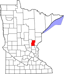
Brunswick
Location of the community of Brunswick
within Brunswick Township, Kanabec County
Usa edcp location map.svg
Red pog.svg
Brunswick
Brunswick (the United States)
Coordinates: 45°47′20″N93°16′33″W / 45.78889°N 93.27583°W / 45.78889; -93.27583
Country United States
State Minnesota
County Kanabec
Township Brunswick Township
Elevation
961 ft (293 m)
Time zone UTC-6 (Central (CST))
  Summer (DST) UTC-5 (CDT)
ZIP code
55051
Area code 320
GNIS feature ID640556 [1]

Brunswick is an unincorporated community in Brunswick Township, Kanabec County, Minnesota, United States. The community is located between Mora and Rock Creek at the junction of State Highway 65 (MN 65) and State Highway 70 (MN 70).

The Groundhouse River flows through the community. Nearby places include Mora, Braham, Coin, Stanchfield, and Grasston.

ZIP codes 55051 (Mora) and 55006 (Braham) meet near Brunswick.

Historical population
CensusPop.Note
1860 30
1870 93210.0%
U.S. Decennial Census [2]

History

Brunswick, platted in 1856, is situated within Brunswick Township. The community is located in Section 1 of the township, but its history traces back to the Hersey, Staples, and Bean Lumber Company, whose logging headquarters were in Section 12 of the township. George and Isaac Staples platted the site of the community, naming it after Brunswick, Maine. With stores, a post office, and mills located in Brunswick, it became the county seat for Kanabec County on March 13, 1859. It retained its status as the county seat until it was transferred to Mora in 1883. [3]

A post office was established at Brunswick in 1860, and remained in operation until 1934. [4]

Related Research Articles

<span class="mw-page-title-main">Wadena County, Minnesota</span> County in Minnesota, United States

Wadena County is a county in the U.S. state of Minnesota. As of the 2020 census, the population was 14,065. Its county seat is Wadena.

<span class="mw-page-title-main">Ramsey County, Minnesota</span> County in Minnesota, United States

Ramsey County is a county located in the U.S. state of Minnesota. As of the 2020 census, the population was 552,352, making it the second-most populous county in Minnesota. Its county seat and largest city is Saint Paul, the state capital and the twin city of Minneapolis. The county was founded in 1849 and is named for Alexander Ramsey, the first governor of the Minnesota Territory.

<span class="mw-page-title-main">Pine County, Minnesota</span> County in Minnesota, United States

Pine County is a county in the U.S. state of Minnesota. As of the 2020 census, the population was 28,876. Its county seat is Pine City. The county was formed in 1856 and organized in 1872. Today, Pine County is the fastest growing county in the state.

<span class="mw-page-title-main">Le Sueur County, Minnesota</span> County in Minnesota, United States

Le Sueur County is a county located in the south central portion of the U.S. state of Minnesota. As of the 2020 census, the population was 28,674. Its county seat is Le Center.

<span class="mw-page-title-main">Kanabec County, Minnesota</span> County in Minnesota, United States

Kanabec County is a county in the East Central part of U.S. state of Minnesota. As of the 2020 census, the population was 16,032. Its county seat is Mora.

<span class="mw-page-title-main">Isanti County, Minnesota</span> County in the United States

Isanti County is a county in the east-central part of the U.S. state of Minnesota. As of the 2020 census, the population was 41,135. Its county seat is Cambridge.

Arthur Township is a township in Kanabec County, Minnesota, United States. The population was 1,905 at the 2000 census.

<span class="mw-page-title-main">Mora, Minnesota</span> City in Minnesota, United States

Mora is a city and the county seat of Kanabec County, Minnesota It is located at the junction of Minnesota highways 23 and 65 and is along the Snake River. The population was 3,665 at the 2020 Census.

<span class="mw-page-title-main">Braham, Minnesota</span> City in Minnesota, United States

Braham is a city in Isanti and Kanabec counties in the U.S. state of Minnesota. The population was 1,769 at the 2020 census.

<span class="mw-page-title-main">Minnesota State Highway 65</span> Highway in Minnesota

Minnesota State Highway 65 is a highway in the east–central and northeast parts of the U.S. state of Minnesota, which starts at its split from I-35W, skipping past the downtown Minneapolis core, only to resume at the intersection with Washington Avenue at the north end of downtown Minneapolis to continue north to its northern terminus at its intersection with U.S. Highway 71 (US 71) in Littlefork near International Falls.

Minnesota State Highway 118 was a highway route number in the U.S. state of Minnesota that was used previously during two different time periods: once during the 1930s and once during the 1990s.

Lewis Lake is an unincorporated community in Brunswick Township, Kanabec County, Minnesota, United States. The community is located between Braham and Ogilvie.

Warman is an unincorporated community in Peace Township, Kanabec County, Minnesota, United States.

Coin is an unincorporated community in Brunswick Township, Kanabec County, Minnesota, United States.

Andree is an unincorporated community in Stanchfield Township, Isanti County, Minnesota, United States.

Grandy is an unincorporated community in Cambridge Township, Isanti County, Minnesota, United States.

Stanchfield is an unincorporated community and census-designated place (CDP) in Stanchfield Township, Isanti County, Minnesota, United States. As of the 2020 census, its population was 103.

Greeley is an unincorporated community in Royalton Township, Pine County, Minnesota, United States.

Woodland is an unincorporated community in Ford Township, Kanabec County, Minnesota, United States.

References

  1. "Brunswick, Minnesota". Geographic Names Information System . United States Geological Survey, United States Department of the Interior.
  2. United States Census Bureau. "Census of Population and Housing".
  3. Upham, Warren. Minnesota Place Names: Their Origin and Historic Significance Archived 2007-06-20 at the Wayback Machine
  4. "Kanabec County". Jim Forte Postal History. Retrieved July 15, 2015.