Mille Lacs County is a county in the East Central part of the U.S. state of Minnesota. As of the 2010 United States Census, the population was 26,097. Its county seat is Milaca. The county was founded in 1857, and its boundary was expanded in 1860.
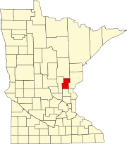
Kanabec County is a county in the East Central part of U.S. state of Minnesota. As of the 2010 United States Census, the population was 16,239. Its county seat is Mora.

Aitkin County is a county in the U.S. state of Minnesota. As of the 2010 United States Census, the population was 16,202. Its county seat is Aitkin. Part of the Mille Lacs Indian Reservation is in the county. The county was created in 1857 and organized in 1871.

Idun Township is a township in Aitkin County, Minnesota, United States. The population was 259 as of the 2010 census.

Mora is a city in, and the county seat of, Kanabec County in Minnesota, United States. It is located at the junction of Minnesota State Highways 23 and 65. The population was 3,571 at the 2010 census.
Minnesota State Highway 65 is a highway in the east–central and northeast parts of the U.S. state of Minnesota, which starts at its split from I-35W, skipping past the downtown Minneapolis core, only to resume at the intersection with Washington Avenue at the north end of downtown Minneapolis to continue north to its northern terminus at its intersection with U.S. Highway 71 (US 71) in Littlefork near International Falls.
Mille Lacs Indian Reservation is the popular name for the land-base for the Mille Lacs Band of Ojibwe in Central Minnesota, about 100 miles (160 km) north of Minneapolis-St. Paul. The contemporary Mille Lacs Band reservation has significant land holdings in Mille Lacs, Pine, Aitkin and Crow Wing counties, as well as other land holdings in Kanabec, Morrison, and Otter Tail Counties. Mille Lacs Indian Reservation is also the name of a formal Indian reservation established in 1855. It is one of the two formal reservations on which the contemporary Mille Lacs Band retains land holdings. The contemporary Mille Lacs band includes several aboriginal Ojibwe bands and villages, whose members reside in communities throughout central Minnesota.
Minnesota State Highway 47 is a 126.872-mile-long (204.181 km) highway in east–central Minnesota, which runs from its intersection with Central Avenue in Minneapolis and continues north to its northern terminus at its intersection with U.S. Highway 169 in Aitkin.

The Snake River is a 104-mile-long (167 km) tributary of the St. Croix River in east-central Minnesota in the United States. It is one of three streams in Minnesota with this name. Its name is a translation from the Ojibwa Ginebigo-ziibi, after the Dakota peoples who made their homes along this river. Kanabec County's name is derived from the Ojibwe word for this river.
The Knife River is a 27.4-mile-long (44.1 km) tributary of the Snake River in east-central Minnesota in the United States. It is one of three streams in Minnesota with this name. Its name is a translation from the Dakota Isaanti. Knife Lake and Santee Sioux are named after this river. In turn Isanti County is named after the Santee Sioux.
Minnesota State Highway 18 is a 78.207-mile-long (125.862 km) highway in east-central Minnesota, which runs from its intersection with State Highway 25 in Brainerd and continues east to its eastern terminus at its intersection with State Highway 23 in Finlayson Township near Askov and Sandstone. The eastern terminus of Highway 18 is less than 1/2 mile west of an interchange with Interstate Highway 35 along Highway 23.
Minnesota State Highway 27 (MN 27) is a 247.623-mile-long (398.511 km) state highway in west-central and east-central Minnesota, which runs from its intersection with MN 28 in Browns Valley and continues east to its interchange with Interstate 35 (I-35) in Moose Lake. For part of its route, it runs concurrently with MN 65 in Kanabec and Aitkin counties between Woodland and Rice River Township.
Brunswick is an unincorporated community in Brunswick Township, Kanabec County, Minnesota, United States. The community is located between Mora and Rock Creek at the junction of State Highway 65 and State Highway 70.
Lewis Lake is an unincorporated community in Brunswick Township, Kanabec County, Minnesota, United States. The community is located between Braham and Ogilvie.
Warman is an unincorporated community in Peace Township, Kanabec County, Minnesota, United States.
Coin is an unincorporated community in Brunswick Township, Kanabec County, Minnesota, United States.
Glen is an unincorporated community and business district in Aitkin County, Minnesota, United States. The community is located southeast of the city of Aitkin at the junction of State Highway 47, Aitkin County Road 12, and 280th Street.
Malmo is an unincorporated community and business district in Aitkin County, Minnesota, United States. The community is located on the northeast corner of Mille Lacs Lake at the junction of State Highway 18, State Highway 47, and Aitkin County Road 2.
The Rum River State Forest is a state forest located in Kanabec, Mille Lacs and Morrison counties in central Minnesota. The forest is nearby the city of Onamia and is along the Rum River, just downstream (south) of Mille Lacs Lake. The forest is managed by the Minnesota Department of Natural Resources. The forest is home to many Northern hardwoods such as maple, oak, ash, elm and basswood that occupy most of the upland areas while tamarack and black spruce are found in lowland and marshy areas.