Grayson, Louisiana

Last updated

Grayson, Louisiana
Village
Village of Grayson
U.S. Post Office, Grayson, LA IMG 2691.JPG
U.S. Post Office in Grayson
Caldwell Parish Louisiana Incorporated and Unincorporated areas Grayson Highlighted.svg
Location of Grayson in Caldwell Parish, Louisiana.
Louisiana in United States (US48).svg
Location of Louisiana in the United States
Coordinates: 32°02′55″N92°06′42″W / 32.04861°N 92.11167°W / 32.04861; -92.11167 Coordinates: 32°02′55″N92°06′42″W / 32.04861°N 92.11167°W / 32.04861; -92.11167
CountryUnited States
StateLouisiana
Parish Caldwell
Government
  MayorMelissa Bratton (I) [1]
Area
[2]
  Total1.27 sq mi (3.30 km2)
  Land1.27 sq mi (3.30 km2)
  Water0.00 sq mi (0.00 km2)
Elevation
164 ft (50 m)
Population
 (2020)
  Total449
  Rank CW: 2nd
  Density352.71/sq mi (136.15/km2)
Time zone UTC-6 (CST)
  Summer (DST) UTC-5 (CDT)
ZIP code
71435
Area code 318
FIPS code 22-31250
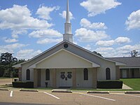
The Grayson United Methodist Church is located near Grayson Town Hall and Grayson Elementary School. First United Methodist Church, Grayson, LA IMG 2687.JPG
The Grayson United Methodist Church is located near Grayson Town Hall and Grayson Elementary School.
Grayson Baptist Church Grayson, LA, Baptist Church IMG 2690.JPG
Grayson Baptist Church

Grayson is a village in Caldwell Parish, Louisiana, United States. The population was 532 at the 2010 census. [3]

Contents

Geography

Grayson is located southwest of the center of Caldwell Parish at 32°2′55″N92°6′42″W / 32.04861°N 92.11167°W / 32.04861; -92.11167 (32.048640, -92.111666). [4] U.S. Route 165 passes through the center of the village, leading northeast 4 miles (6 km) to Columbia, the parish seat, and southwest 13 miles (21 km) to Olla.

According to the United States Census Bureau, Grayson has a total area of 1.3 square miles (3.3 km2), all land. [3]

Notable people

Though primarily associated with Columbia, former Governor John J. McKeithen was born in Grayson in 1918.

The Louisiana historian Hubert D. Humphreys was born and reared in Grayson. He published an article on the village in a 1992 edition of the journal, North Louisiana History . [5]

Demographics

Historical population
CensusPop.Note
1920 337
1930 43529.1%
1940 407−6.4%
1950 45511.8%
1960 428−5.9%
1970 51620.6%
1980 5649.3%
1990 529−6.2%
2000 5310.4%
2010 5320.2%
2020 449−15.6%
U.S. Decennial Census [6]

As of the census [7] of 2000, there were 531 people, 227 households, and 167 families residing in the village. The population density was 418.2 inhabitants per square mile (161.5/km2). There were 260 housing units at an average density of 204.8 per square mile (79.1/km2). The racial makeup of the village was 88.89% White, 9.79% African American, 0.56% from other races, and 0.75% from two or more races. Hispanic or Latino of any race were 1.88% of the population.

There were 227 households, out of which 32.2% had children under the age of 18 living with them, 47.1% were married couples living together, 22.5% had a female householder with no husband present, and 26.4% were non-families. 25.1% of all households were made up of individuals, and 13.7% had someone living alone who was 65 years of age or older. The average household size was 2.34 and the average family size was 2.78.

In the village, the population was spread out, with 26.2% under the age of 18, 9.4% from 18 to 24, 23.0% from 25 to 44, 25.2% from 45 to 64, and 16.2% who were 65 years of age or older. The median age was 38 years. For every 100 females, there were 80.0 males. For every 100 females age 18 and over, there were 70.4 males.

The median income for a household in the village was $28,125, and the median income for a family was $33,250. Males had a median income of $30,556 versus $20,536 for females. The per capita income for the village was $14,491. About 23.2% of families and 25.6% of the population were below the poverty line, including 38.2% of those under age 18 and 16.3% of those age 65 or over.

Related Research Articles

<span class="mw-page-title-main">Mansura, Louisiana</span> Town in Louisiana, United States

Mansura is a town in Avoyelles Parish, Louisiana, United States. The population was 1,419 at the 2010 census. Mansura is home to the Cochon de Lait Festival, and claims to be the Cochon de Lait capital of the world.

<span class="mw-page-title-main">Bienville, Louisiana</span> Village in Louisiana, United States

Bienville is a village in Bienville Parish, Louisiana, United States. The population was 218 at the 2010 census.

<span class="mw-page-title-main">Bryceland, Louisiana</span> Village in Louisiana, United States

Bryceland is a village in Bienville Parish, Louisiana, United States. The population was 108 at the 2010 census.

<span class="mw-page-title-main">Saline, Louisiana</span> Village in Louisiana, United States

Saline is a village in southeastern Bienville Parish, Louisiana, United States. The population was 277 at the 2010 census. Saline is pronounced "Suh-LEEN".

<span class="mw-page-title-main">Clarks, Louisiana</span> Village in Louisiana, United States

Clarks is a rural village in Caldwell Parish, Louisiana, United States. The population was 1,017 at the 2010 census. Clarks is the largest community by population in Caldwell Parish.

<span class="mw-page-title-main">Pine Prairie, Louisiana</span> Village in Louisiana, United States

Pine Prairie is a village in Evangeline Parish, Louisiana, United States. The population was 1,610 at the 2010 census, up from 1,087 in 2000.

<span class="mw-page-title-main">Turkey Creek, Louisiana</span> Village in Louisiana, United States

Turkey Creek is a village in Evangeline Parish, Louisiana, United States. The population was 441 at the 2010 census, up from 356 in 2000.

<span class="mw-page-title-main">Dry Prong, Louisiana</span> Village in Louisiana, United States

Dry Prong is a village in central Grant Parish, Louisiana, United States. It is part of the Alexandria, Louisiana Metropolitan Statistical Area. The population was 436 at the 2010 census.

<span class="mw-page-title-main">Georgetown, Louisiana</span> Village in Louisiana, United States

Georgetown is a village in Grant Parish, Louisiana, United States. It is part of the Alexandria, Louisiana Metropolitan Statistical Area. The population was 327 at the 2010 census.

<span class="mw-page-title-main">East Hodge, Louisiana</span> Village in Louisiana, United States

East Hodge is a village in Jackson Parish, Louisiana, United States. The population was 289 at the 2010 census, down from 366 at the 2000 census. It is part of the Ruston Micropolitan Statistical Area.

<span class="mw-page-title-main">Hodge, Louisiana</span> Village in Louisiana, United States

Hodge is a village in Jackson Parish, Louisiana, United States. The population was 470 at the 2010 census. It is part of the Ruston Micropolitan Statistical Area.

<span class="mw-page-title-main">North Hodge, Louisiana</span> Village in Louisiana, United States

North Hodge is a village in Jackson Parish, Louisiana, United States. The population was 388 at the 2010 census, down from 436 at the 2000 census. It is part of the Ruston Micropolitan Statistical Area.

<span class="mw-page-title-main">Quitman, Louisiana</span> Village in Louisiana, United States

Quitman is a village in Jackson Parish, Louisiana, United States. As of the 2010 census, the village population was 181. Quitman is 15 miles (24 km) south of Ruston on U.S. Highway 167, and 9 miles (14 km) north of Jonesboro, the parish seat of Jackson Parish. It is also adjacent to the Jackson Bienville Wildlife Area.

<span class="mw-page-title-main">Fenton, Louisiana</span> Village in Louisiana, United States

Fenton is a village in Jefferson Davis Parish, Louisiana, United States. The population was 379 at the 2010 census. It is part of the Jennings Micropolitan Statistical Area.

<span class="mw-page-title-main">Cankton, Louisiana</span> Village in Louisiana, United States

Cankton is a village in St. Landry Parish, Louisiana, United States. The population was 484 at the 2010 census. It is part of the Opelousas–Eunice Micropolitan Statistical Area.

<span class="mw-page-title-main">Spearsville, Louisiana</span> Village in Louisiana, United States

Spearsville is a village in Union Parish, Louisiana, United States. The population was 137 at the 2010 census, a decrease from 155 in 2000. It is part of the Monroe Metropolitan Statistical Area.

<span class="mw-page-title-main">Dodson, Louisiana</span> Village in Louisiana, United States

Dodson is a village in Winn Parish, Louisiana, United States. The population was 357 at the 2000 census, which decreased to 337 in 2010.

<span class="mw-page-title-main">Sikes, Louisiana</span> Village in Louisiana, United States

Sikes is a village in Winn Parish, Louisiana, United States. The population was 121 at the 2000 census.

<span class="mw-page-title-main">Tullos, Louisiana</span> Town in Louisiana, United States

Tullos is a town in LaSalle and Winn parishes in the U.S. state of Louisiana, along Castor Creek. The population was 385 at the 2010 census.

<span class="mw-page-title-main">Downsville, Louisiana</span> Village in Louisiana, United States

Downsville is a village in Lincoln and Union parishes in the U.S. state of Louisiana. The population as of the 2010 census was 143, an increase from 118 in the 2000 census.

References

  1. "Election Returns: Caldwell Parish". Louisiana Secretary of State. November 6, 2018. Retrieved November 9, 2018.
  2. "2020 U.S. Gazetteer Files". United States Census Bureau. Retrieved March 20, 2022.
  3. 1 2 "Geographic Identifiers: 2010 Demographic Profile Data (G001): Grayson village, Louisiana". U.S. Census Bureau, American Factfinder. Archived from the original on February 12, 2020. Retrieved August 18, 2014.
  4. "US Gazetteer files: 2010, 2000, and 1990". United States Census Bureau. February 12, 2011. Retrieved April 23, 2011.
  5. Hubert D. Humphreys, "A History of the Village of Grayson, Louisiana," Vol. 23, No. 4 (Fall 1992), pp. 99-143
  6. "Census of Population and Housing". Census.gov. Retrieved June 4, 2015.
  7. "U.S. Census website". United States Census Bureau . Retrieved January 31, 2008.