Great Wheal Charlotte

Last updated

Great Wheal Charlotte
GreatWhealCharlotte 1.jpg
The ruins of Great Wheal Charlotte mine on the South West Coast Path between Porthtowan and Chapel Porth
Location
Cornwall UK location map.svg
Schlaegel und Eisen nach DIN 21800.svg
Great Wheal Charlotte
Location in Cornwall
Location Porthtowan
County Cornwall
CountryEngland
Coordinates 50°17′48″N5°14′06″W / 50.296534°N 5.234939°W / 50.296534; -5.234939
Production
Products Copper
History
Openedbefore 1820
Closed1840

Great Wheal Charlotte, also known as Wheal Charlotte, is an abandoned copper and tin mine lying between St Agnes and Porthtowan in Cornwall, England. All that is left of the mine now is the wall and door arch of an engine house and an adjacent fenced-off mine shaft. The surviving wall is surrounded by rock debris and the extensive remains of spoil tips, mostly of bare rock fragments crisscrossed by paths that link the South West Coast Path with surrounding land owned by the National Trust. [1] Predominantly a copper producer, [2] in its heyday, in the 1830s, the mine extracted ore containing 7.25% copper. It may have partially closed around 1840. [3] However, ore production was high in this year, and records of output extend at least to 1856, and possibly to 1863. [4]

Contents

History

Tin mining in Cornwall can be traced back to medieval times and much earlier still; the tin was usually obtained from stream sediments or from freshly mined ore using open cast techniques. [5] In the sixteenth century through to the eighteenth this was mostly carried out part-time by a land occupier and his family, or tenants, to supplement an income from farming or from a smallholding. [6] Copper was produced in the seventeenth century, largely as a by-product of tin extraction, but grew rapidly during the eighteenth century, with many full-time mines opening as a result of a newfound ability to pump water from deep shafts through the use of steam power. [lower-alpha 1] British coins were first minted using British copper in 1717. [7] By 1800, copper production in Cornwall had reached 55,000 tons of ore per annum. [7]

Great Wheal Charlotte was certainly working in 1820, and probably before then. [3] It may have partially closed in 1840: a lot of equipment, including a 60-inch pumping engine, was sold off in 1842. [3] However, records show total output at the mine in the period 182056 to be 23,100 tons. [4] Copper mines at this time could exceed two hundred meters in depth, some reaching 400 meters, [7] and all access was by ladder, requiring miners, after an exhausting shift in the tunnels, to spend over an hour climbing back to the surface. [8] Only by 1838 was there a hope that future mechanization might provide some relief from this. [7] But by then, the continual deepening of mines and economic changes had made the long-term future of Cornish copper uncertain. From 1860 onwards, large numbers of Cornish miners emigrated or found work overseas. [9] The most recent record of ore production for 'Charlotte' mine is for the period 185463, 7,578 tons in total. [4]

Copper ore production

There were at least six shafts at Great Wheal Charlotte; the main Engine shaft was 150 meters in depth and other shafts included West shaft at 77 meters and Midwinter’s shaft at 132 meters. [3] Annual production reached 2,800 tons of ore at 7.25% copper in three years during the 1830s and in 1840. [4] For comparison, Cornwall’s largest complex of copper mines, Consolidated Mines, lying immediately to the east of Redruth, produced 18,393 tons of ore in 1836. [7] Average annual production in the whole of Cornwall between 1831 and 1837 was 142,785 tons of ore, producing 11,637 tons of copper. [7] Great Wheal Charlotte, therefore, produced a significant quantity of ore during this period, reaching nearly 2% of total Cornish ore production in the years 18346 and again in 1840. This total from over 160 mines. [7]

Remains of Great Wheal Charlotte engine house looking northwards across Chapel Porth towards Wheal Coates mine (National Trust). GreatWhealCharlotte 3.jpg
Remains of Great Wheal Charlotte engine house looking northwards across Chapel Porth towards Wheal Coates mine (National Trust).

At Consolidated Mines, only 9 km away from Great Wheal Charlotte, statistics from 1837 list a total of 2,387 men, women and children working. This was the largest copper ore producer in Cornwall at the time, producing about six and a half times as much ore as Great Wheal Charlotte. [7] As an estimate, therefore, it may be surmised that Great Wheal Charlotte mine in some years in the 1830s had a workforce of around 350 men, women and children. The men largely worked underground and the women and children on the surface, breaking ore into smaller pieces for sorting. Underground work was divided into the excavation of tunnels and shafts for access, and the mining of ore within the lode itself, which was higher status and slightly better paid work.

Engineering

All that remain of the surface buildings is the bob wall of an engine house. [2] This engine house held a 60-inch pumping engine which was installed in 1828. [3] It would have contained two boilers and would have had a chimney. There would have been other pumping engine houses nearby. A 36-inch pumping engine was put up for sale in 1828 and may have been located above Cock's shaft, a shaft 77 meters deep. [3]

Engine shaft at Great Wheal Charlotte is vertical to 150 meters and located next to the remnant of the engine house. [3] The two shallowest mine shafts are William's and Moyle's, each 59 meters deep. Much of the machinery was sold off in 1842. The sale of equipment in 1842 included a dual whim and crusher and two horse whims; [3] a whim was a device like a capstan with ropes and pulleys for hauling material up from underground.

Economic geology and mineralization

Extensive spoil tips crisscrossed with paths meandering across National Trust land from the South West Coast Path. GreatWhealCharlotte 2.jpg
Extensive spoil tips crisscrossed with paths meandering across National Trust land from the South West Coast Path.

The rocks underlying and surrounding Great Wheal Charlotte consist of Devonian mudstones that have been metamorphosed into slate. [4] Such outcrops and pebbles, often containing the remains of numerous quartz veins, can be seen on the beaches of Porth Towan and Chapel Porth. During the Variscan orogeny huge granite intrusions rose into these Devonian sediments. [lower-alpha 2] The heat from these plutons, themselves part of a huge batholith, not only metamorphosed the Devonian sediment but powered the circulation of surface water deep into the crust, causing the precipitation of metal-bearing minerals in veins close to the boundary between the granite and the slate. [10] The largest of these veins are called by Cornish miners ‘lodes’, and the barren Devonian slates surrounding them, ‘killas’. The age of formation of the granite at Great Wheal Charlotte has been dated to 295 Ma, near the beginning of the Permian period, and major polymetallic mineralization took place around 25 million years later. [2]

Lodes in Cornwall are often near-vertical sheets of mineralization containing tin, copper and other minerals, usually found where granite and killas meet. At Great Wheal Charlotte it was copper mineralization in the ‘Main’ lode that was principally sought. [3] Ore minerals from the site recently recovered for examination (201624) include chalcopyrite (a copper sulphide), malachite (a copper carbonate) and cuprite (a copper oxide). [2] Tin in the form of cassiterite and arsenic in the form of arsenopyrite was also found to be present. [2]

Present day

View from Wheal Charlotte National Trust area looking north across Chapel Porth towards the paths leading up to Wheal Coates abandoned mine GreatWhealCharlotte 5.jpg
View from Wheal Charlotte National Trust area looking north across Chapel Porth towards the paths leading up to Wheal Coates abandoned mine

Great Wheal Charlotte is on the South West Coast Path and was purchased by the National Trust in 1956. [11] The mine ruins are contained within a larger area owned by the National Trust that includes the sandy cove at Chapel Porth and hillsides and clifftops surrounding it.

Access to Great Wheal Charlotte can be made from a National Trust car park at Chapel Porth with a relatively short, but steep, climb onto the heathland and spoil scree above. [12] Alternatively, a path leads from the beach at Porthtowan directly across the cliff tops, a walk of about 1.5 km (0.93 mi).

In addition to Great Wheal Charlotte, Wheal Coates mine lies directly to the north of Chapel Porth, with its own car park a little inland from the cove. [13] The site of North Towan mine, an early nineteenth century copper mine which was later worked as New Wheal Charlotte and then Charlotte United, lies 0.5 km (0.31 mi) inland from Great Wheal Charlotte, its later engine house still standing. All are connected by National Trust paths. North Towan mine employed twelve people in 1837. [7]

Heather and gorse carpet this clifftop terrain in a display of purple and yellow flowers in late summer. The old mine waste dumps at Great Wheal Charlotte, however, remain bare of any vegetation due to their lingering heavy metal concentration. [1] They are popular with walkers and the views from the clifftops are spectacular.

Related Research Articles

<span class="mw-page-title-main">Porthtowan</span> Human settlement in England

Porthtowan is a small village in Cornwall, England, UK, which is a popular summer tourist destination. Porthtowan is on Cornwall's north Atlantic coast about 3.5 km (2.2 mi) southwest of St Agnes, 6 km (3.7 mi) north of Redruth, 16 km (9.9 mi) west of Truro and 24 km (15 mi) southwest of Newquay in the Cornwall and West Devon Mining Landscape, a World Heritage Site.

<span class="mw-page-title-main">Mount Wellington Tin Mine</span> Tin mine in St Day, Cornwall, UK

Mount Wellington Tin mine, two miles east of the village of St Day in Cornwall, in the United Kingdom, opened in 1976 and was the first new mine in the region in many years.

<span class="mw-page-title-main">Geevor Tin Mine</span> Former tin mine in Cornwall, England

Geevor Tin Mine, formerly North Levant Mine is a tin mine in the far west of Cornwall, England, between the villages of Pendeen and Trewellard. It was operational between 1911 and 1990 during which time it produced about 50,000 tons of black tin. It is now a museum and heritage centre left as a living history of a working tin mine. The museum is an Anchor Point of ERIH, The European Route of Industrial Heritage. Since 2006, the mine has been part of the UNESCO World Heritage Site Cornwall and West Devon Mining Landscape.

<span class="mw-page-title-main">Botallack Mine</span> Former mine in Cornwall, England

The Botallack Mine is a former mine in Botallack in the west of Cornwall, UK. Since 2006 it has been part of the UNESCO World Heritage Site – Cornwall and West Devon Mining Landscape. The mine is within the Aire Point to Carrick Du Site of Special Scientific Interest (SSSI) and the South West Coast Path passes along the cliff.

<span class="mw-page-title-main">Levant Mine and Beam Engine</span> British mine

Levant Mine and Beam Engine is a National Trust property at Trewellard, Pendeen, near St Just, Cornwall, England, UK. Its main attraction is that it has the world's only Cornish beam engine still operated by steam on its original site. There is also a visitor centre, a short underground tour, and the South West Coast Path leads to Botallack Mine, via a cliff-top footpath.

<span class="mw-page-title-main">Mining in Cornwall and Devon</span> Mining in the English counties of Cornwall and Devon

Mining in Cornwall and Devon, in the southwest of Britain, is thought to have begun in the early-middle Bronze Age with the exploitation of cassiterite. Tin, and later copper, were the most commonly extracted metals. Some tin mining continued long after the mining of other metals had become unprofitable, but ended in the late 20th century. In 2021, it was announced that a new mine was extracting battery-grade lithium carbonate, more than 20 years after the closure of the last South Crofty tin mine in Cornwall in 1998.

<span class="mw-page-title-main">St Agnes, Cornwall</span> Village and civil parish in England

St Agnes is a civil parish and town on the north coast of Cornwall, England, United Kingdom. The village is about five miles (8 km) north of Redruth and ten miles (16 km) southwest of Newquay. An electoral ward exists stretching as far south as Blackwater. The population at the 2011 census was 7,565.

<span class="mw-page-title-main">Gwennap</span> Village and civil parish in Cornwall, England

Gwennap is a village and civil parish in Cornwall, England, United Kingdom. It is about five miles (8 km) southeast of Redruth. Hamlets of Burncoose, Comford, Coombe, Crofthandy, Cusgarne, Fernsplatt, Frogpool, Hick's Mill, Tresamble and United Downs lie in the parish, as does Little Beside country house.

<span class="mw-page-title-main">The Towans</span>

Towan is found in many placenames in Cornwall. However, The Towans usually refers to the three-mile (5 km) stretch of coastal dunes which extends north-east from the estuary of the River Hayle to Gwithian beach with a midpoint near Upton. The South West Coast Path crosses the towans.

<span class="mw-page-title-main">South Crofty</span> Tin and copper mine in Cornwall, England

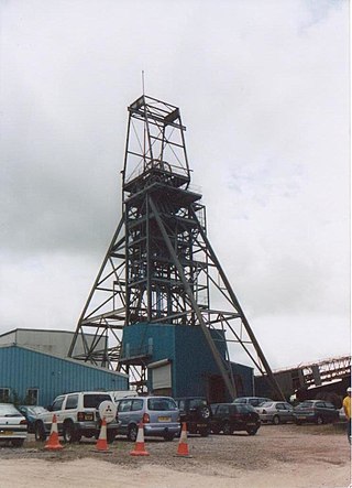
South Crofty is a metalliferous tin and copper mine located in the village of Pool, Cornwall, England. An ancient mine, it has seen production for over 400 years, and extends almost two and a half miles across and 3,000 feet (910 m) down and has mined over 40 lodes. Evidence of mining activity in South Crofty has been dated back to 1592, with full-scale mining beginning in the mid-17th century. The mine went into serious decline after 1985 and eventually closed in 1998. After several changes of ownership, South Crofty is owned by Cornish Metals Inc, which is working to re-open the mine, as of November 2022, having received a permit for dewatering the mine.

<span class="mw-page-title-main">Wheal Peevor</span> Former metalliferous mine in Cornwall, England

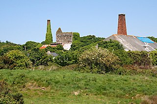
Wheal Peevor was a metalliferous mine located on North Downs about 1.5 miles north-east of Redruth, Cornwall, England. The first mining sett was granted here in around 1701 on land owned by the St Aubyn family. It was originally mined at shallow depths for copper, but when the price for that metal slumped after 1788, the mine was able to change to mining tin ore, which was found deeper down. In the late 18th century Wheal Peevor had the advantage of being drained by the Great County Adit which was around 100 metres deep here. The mine covered only 12 acres but had rich tin lodes. In addition to tin and copper, pyrite was also mined here between 1872 and 1887.

Wheal Vor was a metalliferous mine about 2 miles (3.2 km) north west of Helston and 1 mile (1.6 km) north of the village of Breage in the west of Cornwall, England, UK. It is considered to be part of the Mount's Bay mining district. Until the mid-19th century the mine was known for its willingness to try out new innovations. Although very rich in copper and tin ores, the mine never lived up to its expectations. During the later part of the 19th century it had several periods of closure, with an attempt to reopen it in the 1960s which was not successful mainly because of bureaucracy. Today the site is part of the Cornwall and West Devon Mining Landscape.

<span class="mw-page-title-main">Wheal Busy</span> Disused metalliferous mine in Cornwall, England

Wheal Busy, sometimes called Great Wheal Busy and in its early years known as Chacewater Mine, was a metalliferous mine halfway between Redruth and Truro in the Gwennap mining area of Cornwall, England. During the 18th century the mine produced enormous amounts of copper ore and was very wealthy, but from the later 19th century onwards was not profitable. Today the site of the mine is part of the Cornwall and West Devon Mining Landscape, a UNESCO World Heritage Site.

<span class="mw-page-title-main">East Pool mine</span> Former metalliferous mine in Cornwall,UK

East Pool mine, was a metalliferous mine in the Camborne and Redruth mining area, just east of the village of Pool in Cornwall. Worked from the early 18th century until 1945, first for copper and later tin, it was very profitable for much of its life. Today the site has two preserved beam engines and is part of the Cornwall and West Devon Mining Landscape World Heritage Site. It is owned by the National Trust.

<span class="mw-page-title-main">Consolidated Mines</span> Former metalliferous mine in Cornwall, England

Consolidated Mines, also known as Great Consolidated mine, but most commonly called Consols or Great Consols was a metalliferous mine about a mile ESE of the village of St Day, Cornwall, England. Mainly active during the first half of the 19th century, its mining sett was about 600 yards north–south; and 2,700 yards east–west, to the east of Carharrack. Although always much troubled by underground water, the mine was at times highly profitable, and it was the largest single producer of copper ore in Cornwall. Today the mine is part of the Cornwall and West Devon Mining Landscape World Heritage Site.

<span class="mw-page-title-main">Wheal Coates</span> Former tin mine in Cornwall, England

Wheal Coates is a former tin mine situated on the north coast of Cornwall, UK, on the cliff tops between Porthtowan and St Agnes. It is preserved and maintained by the National Trust.

Wheal Fortune or Great Wheal Fortune is the site of a mine in the civil parishes of Breage and Sithney in west Cornwall. Part of the disused mine was designated as a Site of Special Scientific Interest (SSSI) for its geological interest in 1991 and is also a Geological Conservation Review site of national importance for the minerals on the site.

Wheal Metal is a tin-mining sett in west Cornwall, England, UK. Whilst not as famous as neighbouring Wheal Vor, it was thus described by the Mining Journal in July 1885: " Truly this is a wonderful mine—probably the richest tin mine in the world." It also hosts a very remarkable engine house of the mid-19th century that once stood over Trelawney's shaft on Wheal Vor, and since the Wheal Vor area itself has no visible remains, this is the only large surviving engine house of this group of mines which accounted for over a quarter of Cornish tin production in the mid-19th century.

<span class="mw-page-title-main">South Wheal Frances Mine</span> Former copper and tin mine in Cornwall, England

South Wheal Frances is a former mine accessing the copper and tin of the Great Flat Lode south of Camborne in Cornwall, England.

<span class="mw-page-title-main">Basset Mines</span> Mining company in Cornwall, England

Basset Mines was a mining company formed in Cornwall, England, by the amalgamation of six copper and tin mining setts. It operated from 1896 until 1918, when it was closed due to a fall in the price of tin.

References

  1. 1 2 "Chapel Porth to Towan Cross walk" (PDF). National Trust. Retrieved 3 September 2024.
  2. 1 2 3 4 5 "Wheal Charlotte (Great Wheal Charlotte), Porthtowan, St Agnes, Cornwall, England". mindat.org. Retrieved 6 September 2024.
  3. 1 2 3 4 5 6 7 8 9 "Great Wheal Charlotte". Explorecornwall.org. Retrieved 2 June 2018.
  4. 1 2 3 4 5 Dines, H. G. (1956). The metalliferous mining regions of south-west England. British Geological Survey. Retrieved 14 September 2024.
  5. Carne, Joseph (1839). "Statistics of the Tin-Mines in Cornwall, and of the Consumption of Tin in Great Britain". Journal of the Statistical Society of London. 2 (4 (July, 1839)): 260–8.
  6. Burt, Roger (1991). "The International Diffusion of Technology in the Early Modern Period: The Case of the British Non-Ferrous Mining Industry". The Economic History Review. 44 (2 (May, 1991)): 249–71.
  7. 1 2 3 4 5 6 7 8 9 10 Lemon, Charles (1838). "The Statistics of the Copper Mines of Cornwall". Journal of the Statistical Society of London. 1 (2 (June, 1838)): 65–84.
  8. Harvey, Bryan (1970). "Who started it all?". British journal of Industrial Medicine. 27 (1 (Jan., 1970)): 81–83.
  9. Schwartz, Sharron P (2006). "Bridging "The Great Divide": The Evolution and Impact of Cornish Translocation in Britain and the USA". Journal of American Ethnic History. 25 (2/3 (Winter – Spring, 2006)): 169–89.
  10. S238 Open University course team (1984). The Earth's Physical Resources, Block 3, Part 1, Ore deposits: origin and distribution. Milton Keynes, UK: The Open University Press. p. 49. ISBN   0 335 16157 X.{{cite book}}: CS1 maint: numeric names: authors list (link)
  11. "Wheal Charlotte Mine Cornwall". Cornwall-calling.co.uk. Retrieved 2 June 2018.
  12. "Chapel Porth". National Trust. Retrieved 5 September 2024.
  13. "Wheal Coates". National Trust. Retrieved 5 September 2024.

Notes

  1. The Newcomen atmospheric engine was utilized in Cornish mines early in the eighteenth century, and in 1769 the Scottish engineer James Watt obtained a patent for the use of his own engine which dominated mining for another thirty years. Over the following thirty years, between about 1800 to 1830, the efficiency of steam power in the mines increased another fourfold again. [7]
  2. These intrusions are all part of the vast Cornubian batholith, whose granite outcrops in Devon and Cornwall form many of the upland and moorland areas of these counties.