
Baldhu is a village and parish in Cornwall, England, United Kingdom. It is in the civil parish of Kea.

Balwest is a hamlet in the civil parish of Porthleven in west Cornwall, England, in the United Kingdom . It is in the civil parish of Germoe.

Bodiniel is a group of small settlements in Cornwall, England, United Kingdom one mile (1.6 km) north of Bodmin town centre. It is in the civil parish of Helland.

The River Allen in north Cornwall is one of two rivers of the same name in Cornwall which share this name. In this case the name is the result of a mistake made in 1888 by Ordnance Survey, replacing the name Layne with Allen which is the old name for the lower reaches of the Camel. The other River Allen runs through Truro.
Brea is a village in Cornwall, England, UK, between the towns of Camborne and Redruth. It is in the civil parish of Carn Brea and consists of Brea, Lower Brea, and Higher Brea. A small stream, the Red River, flows through the village and a hill, Carn Brea dominates the landscape to the east, along with its monument to Francis Basset.

Crelly is a moorland in the parish of Wendron in Cornwall, England. On the edges of the moor are Crelly Farm, Crelly Barton and Higher Crelly Farm.
Higher Boscaswell is a hamlet near Pendeen in west Cornwall, England. It is east of Pendeen and on the B road from St Ives to St Just.(where the 2011 census population was included.)
Higher Condurrow is a hamlet in the parish of Camborne, Cornwall, England.
Higher Cransworth is a hamlet in the parish of St Breock, Cornwall, England. It is in the civil parish of St Wenn

Higher Downs is a moorland in the parish of Morvah in west Cornwall, England.

Higher Menadew is a farm west of Luxulyan in Cornwall, England.
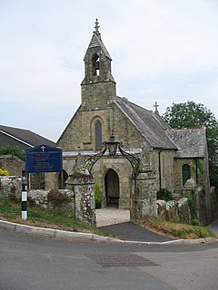
Higher Porthpean is a village south of Duporth and contiguous with Lower Porthpean in Cornwall, England. It has a small church, dedicated to St Levan that is a Grade II building, and that seats 48 people. The church is a Chapel of ease to St Austell Parish Church
Higher Tolcarne is a hamlet in Cornwall, England]. It is near St Mawgan; Tolcarne was one of the two Cornish manors of this name recorded in the Domesday Book, 1086. It is in the civil parish of Mawgan in Pydar
Higher Tremarcoombe is a hamlet in the parish of St Cleer, Cornwall, England.

Lower Porthpean is a coastal hamlet in Cornwall, England, UK. It is close to Higher Porthpean and one mile south of St Austell.

Lower Tregantle is a hamlet in Cornwall, England, UK. It is about half a mile south of Antony; Higher Tregantle is about a quarter of a mile further south. It should be distinguished from Lower Tregantle, a farm near Luxulyan.
Norris Green is a village in Cornwall, England, UK. It was enlarged from a farming hamlet so that it now adjoins the neighbouring village of Higher Metherell. Both settlements are within the civil parish of Calstock which borders the River Tamar, the county boundary with Devon in south-east Cornwall.

Porthmeor consists of two farms, Higher and Lower Porthmeor, in the parish of Zennor in Cornwall, England. It should not be confused with Porthmeor beach at St Ives. Higher Porthmeor lies along the B3306 road which connects St Ives to the A30 road and Lower Porthmeor is nearer the coast.
Trevenen is a hamlet on the A394 main road from Helston to Mabe in west Cornwall, England, United Kingdom. It is south of Wendron.

Trevenen Bal is a hamlet west of Trevenen in west Cornwall, England, United Kingdom.
