Green Acres, North Dakota | |
|---|---|
 Green Acres, North Dakota | |
| Coordinates: 48°50′17″N99°41′24″W / 48.83806°N 99.69000°W | |
| Country | United States |
| State | North Dakota |
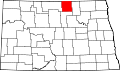
| County | Rolette |
| Area | |
• Total | 1.51 sq mi (3.90 km2) |
| • Land | 1.51 sq mi (3.90 km2) |
| • Water | 0 sq mi (0.00 km2) |
| Elevation | 1,923 ft (586 m) |
| Population (2020) | |
• Total | 605 |
| • Density | 402.0/sq mi (155.21/km2) |
| Time zone | UTC-6 (CST) |
| • Summer (DST) | UTC-5 (CDT) |
| ZIP Code | 58316 |
| Area code | 701 |
| GNIS feature ID | 2584344 [2] |
Green Acres is a census-designated place in Rolette County, North Dakota, United States. Its population was 605 as of the 2020 census. [3]