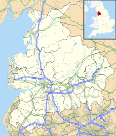
The Forest of Bowland, also known as the Bowland Fells and formerly the Chase of Bowland, is an area of gritstone fells, deep valleys and peat moorland, mostly in north-east Lancashire, England, with a small part in North Yorkshire. It is a western outlier of the Pennines.
Bowland at its most general most often refers to:

The Amounderness Hundred is one of the six subdivisions of the historic county of Lancashire in North West England, but the name is older than the system of hundreds first recorded in the 13th century and might best be described as the name of a Norse wapentake. In the Domesday Book of 1086, it was used for some territories north of the River Ribble included together with parts of Yorkshire. The area eventually became part of Lancashire, sitting geographically between the Rivers Lune and Ribble, in the strip of coast between the Irish Sea and Bowland Forest.

Bentham is a civil parish in North Yorkshire, England, with a population of 3,027 at the 2011 Census. The parish includes the town of High Bentham, occasionally known as Higher Bentham or just Bentham, and the older adjacent village of Low Bentham.

Lancashire is a county of England, in the northwest of the country. The county did not exist in 1086, for the Domesday Book, and was apparently first created in 1182, making it one of the youngest of the traditional counties.
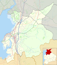
Dunsop Bridge is a village in the civil parish of Bowland Forest High, in the borough of Ribble Valley, Lancashire, England, 9 miles (14 km) north-west of Clitheroe, 15 miles (24 km) south-east of Lancaster and 24.5 miles (39 km) west of Skipton. Historically, the village is part of the West Riding of Yorkshire, but was placed under the administration of Lancashire County Council on 1 April 1974.

Slaidburn is a village and civil parish within the Ribble Valley district of Lancashire, England. The parish covers just over 5,000 acres of the Forest of Bowland.

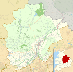
Bowland Forest High is a civil parish in the Ribble Valley district of Lancashire, England, covering some 20,000 acres (80 km2) of the Forest of Bowland. It fell within the ancient boundaries of the West Riding of Yorkshire. According to the 2001 census, the parish had a population of 163, falling to 144 at the 2011 Census. The parish includes the settlements of Hareden, Sykes, and Dunsop Bridge. It covers Sykes Fell, Whins Brow, Croasdale Fell and Wolfhole Crag. Before 1974, it formed part of Bowland Rural District in the West Riding of Yorkshire.
The River Hodder is in Lancashire, England. It is a County Biological Heritage Site.

Gisburn is a village and civil parish within the Ribble Valley borough of Lancashire, England. Historically within the West Riding of Yorkshire, it lies 8 miles (13 km) northeast of Clitheroe and 11 miles (18 km) west of Skipton. The civil parish had a population of 506, recorded in the 2001 census, increasing to 521 at the 2011 Census.

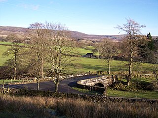
The Trough of Bowland is a valley and high pass in the Forest of Bowland Area of Outstanding Natural Beauty, Lancashire, England.

Grindleton is a village and civil parish in the Ribble Valley district of the English county of Lancashire, formerly in the West Riding of Yorkshire. Its 3,700 acres sit within the Forest of Bowland. The population of the civil ward taken at the 2011 census was 772.

Newsholme is a small village and civil parish in the Ribble Valley, Lancashire, England, but lies within the historic West Riding of Yorkshire. According to the 2001 census, the parish had a population of 50, however the United Kingdom Census 2011 grouped the parish with Horton and Paythorne, giving a total of 253. Today it lies near the boundary with North Yorkshire on the A682, 4 miles (6 km) north of Barnoldswick and 12 miles (19 km) west of Skipton.

The Great Stone of Fourstones, or the Big Stone as it is known locally, is a glacial deposit on the moorlands of Tatham Fells, England, straddling the county border between North Yorkshire and Lancashire, near Bentham in the District of Craven.
Easington is a civil parish within the Ribble Valley district of Lancashire, England, with a population in 2001 of 52. The Census 2011 population details have been grouped with the parish of Slaidburn. Before 1974, it formed part of Bowland Rural District in the West Riding of Yorkshire. It covers just over 9000 acres.

Gisburn Forest is a civil parish in the Ribble Valley, in Lancashire, England. Mainly lying within the Forest of Bowland Area of Outstanding Natural Beauty, the parish includes the larger part of the village of Tosside and the hamlet of Grunsagill to the south. Historically, the parish lay within the West Riding of Yorkshire. It had a population of 151 at the 2011 Census.
The geology of Lancashire in northwest England consists in the main of Carboniferous age rocks but with Triassic sandstones and mudstones at or near the surface of the lowlands bordering the Irish Sea though these are largely obscured by Quaternary deposits.
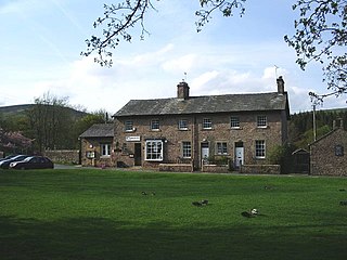
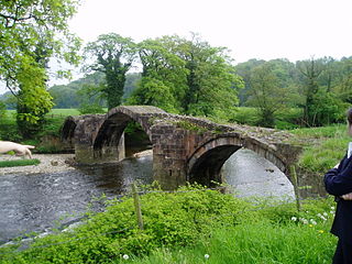
Bowland Forest High is a civil parish in Ribble Valley, Lancashire, England. It contains eight listed buildings that are recorded in the National Heritage List for England. All of the listed buildings are designated at Grade II, the lowest of the three grades, which is applied to "buildings of national importance and special interest". The parish contains the village of Dunsop Bridge, and otherwise consists of farmland and moorland. The listed buildings comprise houses, a bridge, a milestone and a boundary stone.
Grizedale Bridge is a Grade II listed bridge in the English parish of Over Wyresdale, Lancashire. The structure, which dates to the 19th century, carries Rakehouse Brow over the River Grizedale. A Grade II listed structure, it is in sandstone and consists of a single elliptical arch and has a solid parapet with a rounded top.

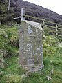
The Bowland Forest High milestone is an historic milestone marker in the English parish of Bowland Forest High, in the Trough of Bowland, Lancashire. A Grade II listed structure, erected in 1739, the milestone is in sandstone and has a rectangular plan and a shaped top. It is inscribed with the distances in miles, on one face to Lancaster and to Clitheroe, and on the other face to Slaidburn and to Hornby.