
Markham is a city in the Regional Municipality of York, Ontario, Canada. It is approximately 30 km (19 mi) northeast of Downtown Toronto. In the 2016 Census, Markham had a population of 328,966, which ranked it the largest in York Region, fourth largest in the Greater Toronto Area (GTA), and 16th largest in Canada.

Buttonville is a suburban planned neighbourhood from a former police village in the city of Markham, Ontario, Canada, west of the larger Unionville neighbourhood. the former hamlet and police village named after its founder, John Button.
Unionville is a neighbourhood and former village in Markham, Ontario, Canada 33 km northeast of Downtown Toronto and 4 km east of southern Richmond Hill. The boundaries of Unionville are not well-defined, as it is an unincorporated community. Several neighbourhoods claim to be part of it however, this has been disputed between the various wards.

Milliken GO Station is a GO Transit train station located in the Scarborough district of Toronto, Ontario, Canada, near the city's northern border. It is located in the neighbourhood of Milliken, Ontario. The station originally opened on September 7, 1982 on the Stouffville line but was relocated on September 6, 2005 because the curve of the original station made it difficult for the operator to see, and it would allow a parking lot to be built on the other side, along with making the station accessible.

The history of Markham, Ontario dates back several millennia. What would become Markham, Ontario was home to First Nations long before European settlement. Seasonal settlements were found from 900 BC to 1650, but traces of these first residence were buried before the area was farmed.
Milliken and Milliken Mills are neighbourhoods in the cities of Toronto and Markham. Milliken is situated in the north west section of Scarborough, whereas Milliken Mills is situated in the south-central portions of Markham. The neighbourhoods are centered on Kennedy Road and Steeles Avenue, the latter street serving as the boundary between the cities of Markham and Toronto.
Victoria Square is an unincorporated community in Markham, Ontario, Canada. The community was formed in the early nineteenth century.
Box Grove(Census Tract 5350400.01) is an original community in Markham, Ontario.

Armadale is a neighbourhood that overlaps into the city of Markham and the former city of Scarborough in Toronto, Ontario, Canada. The historical community is situated in the south-east of Markham and north-east of Scarborough.
Cedar Grove is a community in Markham, Ontario on the Little Rouge River. It is centred on 14th Avenue and Reesor Road and within the boundaries of the future national Rouge Park.
Mount Joy is a community located in north part of Markham, Ontario, Canada near Highway 48 and 16th Avenue and part of the former Township of Markham.
Brown's Corners is an unincorporated community in Markham, Regional Municipality of York in the Greater Toronto Area of Ontario, Canada and located near the corner of Woodbine Avenue and Highway 7. The community, founded in 1842, was named for local settler Alexander Brown, Sr. (1771–1851) who acquired 100 acres (40 ha) in 1838. Beaver Creek flows through it.

Markham Museum is a 25-acre (10 ha) open-air museum located in Markham, Ontario, Canada. It is dedicated to the preservation of old buildings and artefacts from Markham's past, especially as the original rural village has become an urban centre.

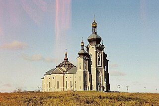
Main Street Unionville is a collector route that runs through the historical suburban community of Unionville, in Markham, Ontario, Canada. Like most other Main Streets, the street serves as an important road for local tourism development. All along the road, the street has structures that are virtually unchanged from its founding in 1794. Renowned for its pubs, parks, restaurants, and its historical European view, the road also hosts the annual Unionville Festival, which draws several thousand visitors to the neighbourhood.
Cashel, Ontario is a small hamlet situated in Unionville, Ontario located at the intersection of Elgin Mills Road and York Regional Road 67. Originally it was called Crosby Corners after John Crosby, the village's first store owner, who came originally from New York State. The name was changed to Cashel in 1851 with the opening of its first post office. It was likely named after Cashel in Ireland. In 1851 the community had a sawmill, cobbler shop, blacksmith shop, wagon shop, inn and tavern, Masonic Lodge, and Presbyterian church. In 1890 Peaches United Church was built on land from farmer Thomas Peach at 10762 McCowan Road. The church is a historic site and not operating since the 1960s to 1970s, but cemetery remains in active use. The east west sideroad along the church was locally called Peaches (Peach's) Sideroad or otherwise known as Elgin Mills Road.
Berczy Village is a residential neighbourhood in Markham, Ontario, Canada. It is bounded to the north by Major Mackenzie Drive, to the east by McCowan Road, to the south by 16th Avenue, and to the west by Kennedy Road. This area is north of Unionville. The community is named after William Berczy, Markham's founder. The name can be found on limestone plaques throughout the community's many arterial road entrances.
Downtown Markham is the central business district of Markham, Ontario, Canada currently being developed. It is located within Markham Centre and Unionville and is proposed to serve as the heart of Markham. Businesses in the district are expected to employ as many as 16,000 individuals, and it may house as many as 10,000 residents. The development will have a high density of residential, retail, commercial and mixed-use structures. The community is being developed, built and wholly financed by The Remington Group Inc.
Mongolia is an historical community in Markham, Ontario centred on 10th Line and Elgin Mills Rd. East, immediately south of the Town of Whitchurch-Stouffville. The hamlet lies completely within the expropriated federal Pickering Airport lands and also within the proposed boundaries of a future national Rouge Park.
Milnesville is a historic community of Markham, Ontario on the 8th Line or 8th Concession Road, between Elgin Mills Road and Major Mackenze Drive, and the Little Rouge Creek.

Dollar is a former community of Markham Township, now the city of Markham and city of Richmond Hill, Ontario, Canada and was located near the corner of Leslie Street and 15th Avenue. In 1869, Dollar was granted a post office, which was located on the north-west corner of Line 3 and 15th Avenue. In 1871 Dollar also had general store, a blacksmith shop and a church. The Zion Wesleyan Methodist Church was built about 1870 on Lot 10, Concession 3, on the east side of Line 3, just south of the intersection.
