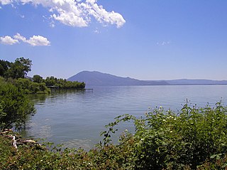
Middletown is a census-designated place (CDP) in Lake County, California, United States. Its population was 1,323 at the 2010 census, up from 1,020 at the 2000 census. Middletown was given its name because it is halfway between Lower Lake and Calistoga which is 17 miles (27 km) to the south. The town was severely damaged by the 2015 Valley Fire.
Cold Springs is a census-designated place (CDP) in Washoe County, Nevada, United States. It is located just off U.S. Route 395 in the northwestern part of the Reno–Sparks Metropolitan Statistical Area, adjacent to the California state line. The population was 8,544 at the 2010 census.

Harbin is the capital of Heilongjiang province, and largest city in the northeastern region of the People's Republic of China. Holding sub-provincial administrative status, Harbin has direct jurisdiction over nine metropolitan districts, two county-level cities and seven counties. Harbin is the eighth most populous Chinese city according to the 2010 census, the built-up area had 5,282,093 inhabitants, while the total population of the sub-provincial city was up to 10,635,971. Harbin serves as a key political, economic, scientific, cultural, and communications hub in Northeast China, as well as an important industrial base of the nation.

The Songhua River is one of the primary rivers of China, and the largest tributary of the Amur River. It flows about 1,434 kilometres (891 mi) from the Changbai Mountains on the China–North Korea border through China's northeastern Jilin and Heilongjiang provinces. The river drains 557,180 square kilometres (215,130 sq mi) of land, and has an annual discharge of 2,463 cubic metres per second (87,000 cu ft/s).
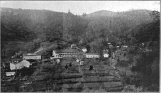
Harbin Hot Springs is a non-profit hot spring retreat and workshop center at Harbin Springs in Lake County, Northern California. Named after Matthew Harbin, a pioneer who settled in the Lake County area. It is located about two hours northeast of the San Francisco Bay Area, in the United States. The facility was partially destroyed in the Valley Fire in September 2015, and was temporarily closed; as of September 2017 it was announced the resort would reopen in early spring 2018.

Putah Creek is a major stream in Northern California, a tributary of the Yolo Bypass, and ultimately, the Sacramento River. The 85-mile-long (137 km) creek has its headwaters in the Mayacamas Mountains, a part of the Coast Range, and flows east through two dams. First, Monticello Dam forms Lake Berryessa, below which Putah Creek forms the border of Yolo and Solano Counties, and then flows to the Putah Diversion Dam and Lake Solano. After several drought years in the late 1980s, the majority of Putah Creek went dry, prompting a landmark lawsuit that resulted in the signing of the Putah Creek Accord in 2000. The Accord established releases from the dams to maintain stream flows in Putah Creek, with natural flow regimes which spike in winter/spring and ebb in summer/fall. The restoration of natural flow regimes has resulted in a doubling of riparian bird species and a return of spawning native steelhead trout and Chinook salmon, as well as protecting the livelihood of farmers on the lower watershed.

Stege, founded in 1876, was an unincorporated community in western Contra Costa County, California, United States. The town has now been annexed and absorbed by the cities of Richmond and El Cerrito, California. It was located on the Southern Pacific Railroad 1.5 miles (2.4 km) south-southeast of downtown Richmond, at an elevation of 23 feet. The site is now located in the area known as the Richmond Annex, at coordinates: 37°55′00″N122°19′38″W.

Enterprise is a former settlement in Butte County, California. It was located 5 miles (8.0 km) west-northwest of Forbestown on the South Fork of the Feather River, at an elevation of 902 feet. In 1968, it was inundated by Lake Oroville.
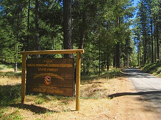
Boggs Mountain Demonstration State Forest is a state forest located on State Route 175, eight miles (13 km) south of Clear Lake in Lake County, California, USA. It is one of the largest mountains in the area, with a length of 10 miles (16 km) east to west and width of 4 miles (6 km) north to south. The mountain's highest point is 3,750 feet (1,143 m) elevation. Like nearby mountains such as Cobb Mountain, Boggs is volcanic in origin. It receives heavy rainfall, winter snow and has at least two perennial springs. Boggs Mountain State Forest is managed by the California Department of Forestry (CDF). CDF purchased 3,433 acres (13.89 km2) in 1949 from the Calso Company for 38,000 dollars Due to hazards from the Valley Fire, the forest is now closed until further notice.
Box Springs is an unincorporated community in Riverside County, California. Box Springs is located 5 miles (8.0 km) east-southeast of downtown Riverside on Interstate 215/State Route 60.

Rich Gulch is an unincorporated community in Calaveras County, California, 5 miles (8.0 km) east-northeast of Mokelumne Hill. It lies at an elevation of 1903 feet.
Canyon is a former gold mining town in El Dorado County, California. It was located 5 miles (8.0 km) southeast of Shingle Springs on Big Canyon Creek.
Cold Springs is a census-designated place in El Dorado County, California. It is located 4 miles (6.4 km) west of Placerville, at an elevation of 1207 feet. It has a population of 446.
Rock Springs is a former settlement in Kern County, California. It was located 0.5 miles (0.8 km) south-southeast of Mount Adelaide, at an elevation of 2280 feet. Rock Springs still appeared on maps as of 1914.
Soda Springs is an unincorporated community and census-designated place (CDP) in Nevada County, California, United States. Soda Springs is located 3 miles (4.8 km) west of Donner Pass. The population was 81 at the 2010 census.
Harbin Springs is an unincorporated community in Lake County, California. It is located 3.5 miles (5.6 km) east-southeast of Whispering Pines, at an elevation of 1555 feet. It is the site of the Harbin Hot Springs.
Bass Lake Annex is an unincorporated community in Madera County, California. It lies at an elevation of 3369 feet.
Rancho Rio de Jesus Maria was a 26,637-acre (107.80 km2) Mexican land grant in present-day Yolo County, California given in 1843 by Governor Manuel Micheltorena to Thomas M. Hardy. The name refers to Rio de Jesús María, now known as Cache Creek. The grant, north of Woodland, extended along Cache Creek, from Rancho Quesesoni on the east to the Sacramento River.
Napa Soda Springs is an unincorporated community in Napa County, California. It lies at an elevation of 705 feet. Napa Soda Springs is located 5 miles (8.0 km) east-southeast of Yountville.
Spring Hill is an unincorporated community in Nevada County, California. Spring Hill is located 1.25 miles (2.0 km) northeast of Grass Valley. It lies at an elevation of 2674 feet.