Haskell Limestone is a geological unit name originating in Kansas and used in adjoining states. The Pennsylvanian period[1] unit was named by R.C. Moore for the Haskell Institute in the southeast of Lawrence, Kansas in 1931.[1] The name has been applied to various beds within this range, and assigned as a member variously to the Lawrence Formation, Cass Formation, and Stranger Formation, and significant legacy literature exists for each classification. These three formations now comprise the Douglas Group.[2]
In 2002, within the effort to improve the correlation of Missourian stage geology between the states of Missouri and Kansas, as well as Nebraska and Iowa, the Haskell was assigned in Kansas to the Cass Formation as its lowest member (on the basis of distinct changes in fossil species).[2]
Distribution and outcrop
The Haskell Limestone is recognized in deep hydrocarbon well logs throughout most of the state of Kansas; the "hot shale" gamma ray log "kicks" associated with the Haskell unit make it an easily identifiable datum/marker bed.[3][4] However, as a stage in the Pennsylvania-Permian marine embayment of Kansas (Midcontinent Basin), the unit extends only limited distances into Oklahoma, Colorado, Nebraska, Missouri, and Iowa.[5]
The Haskell Limestone's outcrop extends from northeast Oklahoma through Douglas County, Kansas, continuing into the adjoining corners of Nebraska, Missouri, and Iowa.[5]
Blue Jacket's Crossing
Proceeding west from Independence, Missouri, the Oregon Trail kept a distance south from the incised bluffs nearer the Kansas River. However, it was unavoidable to cross the Wakarusa River and gain the crest of the hogback ridge between the Wakarusa and Kansas Rivers. Here, the Wakarusa had steep banks about 20 feet high. Moreover, on the south bank, the river cut into the outcrop of the Haskell Limestone as seen above. To cross the rivers, westbound wagons had to be unloaded and disassembled. The cargo and wagon parts were lowered down the limestone bed, rafted across the river, and pulled by rope up the other bank. Shawnee Indian Paschal Fish, who had settled on the river, assisted travelers in the crossing.[6] In 1855, Shawnee chief and Methodist minister Charles Blue Jacket, received authority to create a crossing by cutting ramps into the limestone and soils of the banks, greatly speeding transport across the river.[6]
City parks in Eudora commemorate Blue Jacket's Crossing and Pashal Fish.[7]
Viewing and access
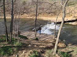
Public waterfall over the Haskell Limestone at Clinton Lake outlet park
An outcrop of the Haskell Limestone (pictured above) occurs on the bridge right-of-way of Douglas County Highway 1057 a half mile south of the E 1900 Road exit of the K-10 between Lawrence and Eudora.[8] The actual historic Blue Jacket’s Crossing is about 1 mile east of this bridge.[9]
The Clinton Lake Dam was constructed across the Wakarusa River valley just upstream of where that river has cut down through the Haskell Limestone, forming a waterfall (pictured right). This waterfall is a public feature of the Clinton Lake Outlet Park. The outcrop of the Haskell Limestone is generally present in the river's banks from here to the Kansas River.
↑ Padgett, Philip C. O. (1988), Petrology, Diagenesis and Depositional Environment of the Tonkawa Sandstone in Southwestern Dewey County, Oklahoma(PDF), retrieved 2022-04-02, The Tonkawa Sandstone is contained within a sequence of strata defined at the base by the Avant Limestone and at the top by a "hot-shale" gamma ray marker overlying the Haskell Limestone (Fig. 2). This "hot-shale" marker is termed the Haskell Marker in this study. The interval defined by the top of the Avant Limestone and by the base of the Haskell Marker is termed the Tonkawa Interval.
↑ Andrew Cullen (2020). "A model for an unconventional trap in low permeability upper Tonkawa shallow marine sandstones in Dewey, Roger Mills, and Ellis Counties, Oklahoma". Shale Shaker. 71 (6): 222–237. Retrieved 2022-04-02. Stacking patterns and electro facies tied to core record an initial regression followed by a transgressive succession capped by the Haskell "hot shale" which is present in areas where the regionally extensive Haskell Limestone is absent. Fitzjarrold and Puckette (2015) document an overall vertical succession of facies from prodelta, delta front, distributary mouth bar, distributary channel, ....
↑ "Eudora Parks". Eudora Parks & Recreation. Bluejacket Park ... CPA Park ... the park also is the home for the statue of Chief Paschal Fish and his daughter, Eudora, the town's namesake. ... Paschal Fish Park: The park is named after Shawnee Chief Paschal Fish, who owned much of the land in Eudora's early days.
↑ "Douglas County". County Geologic Maps. Kansas Geological Survey. p.Douglas County T. 13 S., R. 20 E. [Map showing outcrop of the Top of the Haskell Limestone on the south bank of the Wakarusa at the E1900 bridge (top center)]
↑ "Quantrill's 1863 Lawrence Raid". The Civil War Muse. p.Stop 9: Bluejacket Crossing. Map showing location of the Bluejacket Crossing tour stop.
This page is based on this Wikipedia article Text is available under the CC BY-SA 4.0 license; additional terms may apply. Images, videos and audio are available under their respective licenses.