
The Ring of Fire is a tectonic belt of volcanoes and earthquakes, about 40,000 km (25,000 mi) long and up to about 500 km (310 mi) wide, which surrounds most of the Pacific Ocean. The exact number of volcanoes within the Ring of Fire is not universally agreed but, depending on which regions are included in any particular count, it contains 750 and 915 active or dormant volcanoes, around two-thirds of the world total. About 90% of the world's earthquakes, including most of its largest, occur within the belt.

The Taupō Volcanic Zone (TVZ) is a volcanic area in the North Island of New Zealand that has been active for at least the past two million years and is still highly active. Mount Ruapehu marks its south-western end and the zone runs north-eastward through the Taupō and Rotorua areas and offshore into the Bay of Plenty. It is part of the larger Central Volcanic Region that extends further westward through the western Bay of Plenty to the eastern side of the Coromandel Peninsula and has been active for four million years. At Taupō the rift volcanic zone is widening east–west at the rate of about 8 mm per year while at Mount Ruapehu it is only 2–4 mm per year but this increases at the north eastern end at the Bay of Plenty coast to 10–15 mm per year. It is named after Lake Taupō, the flooded caldera of the largest volcano in the zone, the Taupō Volcano and contains a large central volcanic plateau as well as other landforms associated with its containing tectonic intra-arc continental Taupō Rift.

The Kermadec Islands are a subtropical island arc in the South Pacific Ocean 800–1,000 km (500–620 mi) northeast of New Zealand's North Island, and a similar distance southwest of Tonga. The islands are part of New Zealand. They are 33.6 km2 (13.0 sq mi) in total area and uninhabited, except for the permanently staffed Raoul Island Station, the northernmost outpost of New Zealand.

James Healy Seamount is a submarine volcano located among the South Kermadec Ridge Seamounts south of New Zealand's Kermadec Islands. It consists of a volcanic cone that reaches a depth of 1,150 metres (3,770 ft) below sea level, two 2–2.5 kilometres (1.2–1.6 mi) and 1.3 kilometres (0.81 mi) wide calderas and a parasitic cone that reaches a depth of 950 metres (3,120 ft) below sea level. The flanks of the volcano are covered with pumice and volcanic rocks, and hydrothermal venting occurs inside the caldera.

The Brothers Seamount is a Pacific Ocean submarine volcano in the Kermadec Arc, 340 kilometres (210 mi) north east of New Zealand's Whakaari/White Island. It is one of the South Kermadec Ridge Seamounts.

The Kermadec-Tonga subduction zone is a convergent plate boundary that stretches from the North Island of New Zealand northward. The formation of the Kermadec and Tonga Plates started about 4–5 million years ago. Today, the eastern boundary of the Tonga Plate is one of the fastest subduction zones, with a rate up to 24 cm/yr. The trench formed between the Kermadec-Tonga and Pacific Plates is also home to the second deepest trench in the world, at about 10,800 m, as well as the longest chain of submerged volcanoes.

West Mata is an active submarine volcano located in the northeastern Lau Basin, roughly 200 km (124 mi) southwest of the Samoan Islands. It is part of the Tonga-Kermadec volcanic arc, which stretches from the North Island of New Zealand to Samoa. The volcano was first discovered in 2008 by scientists aboard the R/V Thompson research vessel, using sonar mapping and a remotely operated vehicle (ROV) to explore the seafloor. At the same time West Mata was discovered, multiple neighboring volcanoes—most of them hydrothermally active—were discovered as well, including Volcano O, Tafu-Maka, Northern Matas and East Mata.
The Lau Basin is a back-arc basin at the Australian-Pacific plate boundary. It is formed by the Pacific plate subducting under the Australian plate. The Tonga-Kermadec Ridge, a frontal arc, and the Lau-Colville Ridge, a remnant arc, sit to the eastern and western sides of the basin, respectively. The basin has a raised transition area to the south where it joins the Havre Trough.

The 2012 Kermadec Islands eruption was a major undersea volcanic eruption that was produced by the previously little-known Havre Seamount near the L'Esperance and L'Havre Rocks in the Kermadec Islands of New Zealand. The large volume of low density pumice produced by the eruption accumulated as a large area of floating pumice, a pumice raft, that was originally covering a surface of 400 square kilometres, spread to a continuous float of between 19,000 and 26,000 square kilometres and within three months dispersed to an area of more than twice the size of New Zealand.

The Pacific Ocean evolved in the Mesozoic from the Panthalassic Ocean, which had formed when Rodinia rifted apart around 750 Ma. The first ocean floor which is part of the current Pacific Plate began 160 Ma to the west of the central Pacific and subsequently developed into the largest oceanic plate on Earth.
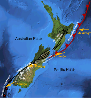
The Hikurangi Margin is New Zealand's largest subduction zone and fault.
The Tonga-Kermadec Ridge is an oceanic ridge in the south-west Pacific Ocean underlying the Tonga-Kermadec island arc. It is a result of the most linear, fastest converging, and seismically active subduction boundary on Earth, the Kermadec-Tonga subduction zone, and consequently has the highest density of submarine volcanoes.
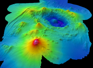
Monowai Seamount is a volcanic seamount to the north of New Zealand. It is formed by a large caldera and a volcanic cone just south-southeast from the caldera. The volcanic cone rises to depths of up to 100 metres (330 ft) but its depth varies with ongoing volcanic activity, including sector collapses and the growth of lava domes. The seamount and its volcanism were discovered after 1877, but only in 1980 was it named "Monowai" after a research ship of the same name.

NW Rota-1 is a seamount in the Mariana Islands, northwest of Rota, which was discovered through its hydrothermal activity in 2003. The volcano has been observed to be erupting underwater, the first time that submarine explosive eruptions have been directly witnessed.
Whakatāne Seamount is a submarine stratovolcano situated some 130 kilometres (81 mi) off the Bay of Plenty coastline of New Zealand. It is found within the Kermadec Arc, and is one of the northernmost volcanoes of the Taupō Volcanic Zone and is usually recognised as the most southern of the South Kermadec Ridge Seamounts. The seamount rises some 1,200 metres (3,900 ft) from the seafloor, and reaches 900 metres (3,000 ft) below sea level at its highest point.
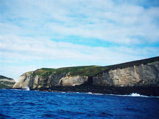
Macauley Island is a volcanic island in New Zealand's Kermadec Islands, approximately halfway between New Zealand's North Island and Tonga in the southwest Pacific Ocean. It is part of a larger submarine volcano that features a 10.5 by 7 kilometres wide underwater caldera northwest of Macauley Island. Two islets, Haszard Island and Newcome Rock, lie east offshore of Macauley Island. The island is mostly surrounded by high cliffs that make accessing it difficult; the inland parts are mostly gently sloping terrain covered with ferns and grasses.

Curtis Island is an island in the southwest Pacific. It is a volcanic island which, together with neighbouring Cheeseman Island, belongs to the Kermadec Islands, an outlying island group of New Zealand. It is a volcanic island with a fumarolically active crater, while vegetated slopes are nested by seabirds. There are uncertain reports of eruptions and the island has been uplifted by about 18 m (59 ft) during the past 200 years.
The South Kermadec Ridge Seamounts are a continuation of the volcanic island arc, formed at the convergent boundary where the Pacific Plate subducts under the Indo-Australian Plate. The subducting Pacific Plate created the Kermadec Trench, the second deepest submarine trench, to the east of the islands. The seamounts lie along the western aspect of the undersea Kermadec Ridge, which runs southwest from the Kermadec Islands towards the North Island of New Zealand and northeast towards Tonga.

The Taupō Rift is the seismically active rift valley containing the Taupō Volcanic Zone, central North Island of New Zealand.

The Havre Trough is a currently actively rifting back-arc basin about 100 km (62 mi) to 120 km (75 mi) wide, between the Australian Plate and Kermadec microplate. The trough extends northward from New Zealand's offshore Taupō Volcanic Zone commencing at Zealandia's continental shelf margin and continuing as a tectonic feature, as the Lau Basin which currently contains active seafloor spreading centers. Its eastern margin is defined by the Kermadec Ridge created by Pacific Plate subduction under the Kermadec microplate, while the western margin is the remnant Lau-Colville Ridge.

