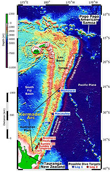
The Tonga Trench is an oceanic trench located in the southwestern Pacific Ocean. It is the deepest trench in the Southern hemisphere and the second deepest on Earth after the Mariana Trench. The fastest plate-tectonic velocity on Earth is occurring at this location, as the Pacific Plate is being subducted westward in the trench.

The Hawaiian–Emperor seamount chain is a mostly undersea mountain range in the Pacific Ocean that reaches above sea level in Hawaii. It is composed of the Hawaiian ridge, consisting of the islands of the Hawaiian chain northwest to Kure Atoll, and the Emperor Seamounts: together they form a vast underwater mountain region of islands and intervening seamounts, atolls, shallows, banks and reefs along a line trending southeast to northwest beneath the northern Pacific Ocean. The seamount chain, containing over 80 identified undersea volcanoes, stretches about 6,200 km (3,900 mi) from the Aleutian Trench in the far northwest Pacific to the Kamaʻehuakanaloa Seamount, the youngest volcano in the chain, which lies about 35 kilometres (22 mi) southeast of the Island of Hawaiʻi.
The Ontong Java Plateau (OJP) is a massive oceanic plateau located in the southwestern Pacific Ocean, north of the Solomon Islands. The OJP was formed around 120 million years ago (Ma) with a much smaller volcanic event around 90 Ma. Two other southwestern Pacific plateaus, Manihiki and Hikurangi, now separated from the OJP by Cretaceous oceanic basins, are of similar age and composition and probably formed as a single plateau and a contiguous large igneous province together with the OJP. When eruption of lava had finished, the Ontong Java–Manihiki–Hikurangi plateau covered 1% of Earth's surface and represented a volume of 80 million km3 (19 million cu mi) of basaltic magma. This "Ontong Java event", first proposed in 1991, represents the largest volcanic event of the past 200 million years, with a magma eruption rate estimated at up to 22 km3 (5.3 cu mi) per year over 3 million years, several times larger than the Deccan Traps. The smooth surface of the OJP is punctuated by seamounts such as the Ontong Java Atoll, one of the largest atolls in the world.
The Kermadec Trench is a linear ocean trench in the south Pacific Ocean. It stretches about 1,000 km (620 mi) from the Louisville Seamount Chain in the north (26°S) to the Hikurangi Plateau in the south (37°S), north-east of New Zealand's North Island. Together with the Tonga Trench to the north, it forms the 2,000 km (1,200 mi)-long, near-linear Kermadec-Tonga subduction system, which began to evolve in the Eocene when the Pacific Plate started to subduct beneath the Australian Plate. Convergence rates along this subduction system are among the fastest on Earth, 80 mm (3.1 in)/yr in the north and 45 mm (1.8 in)/yr in the south.

The Kermadec-Tonga subduction zone is a convergent plate boundary that stretches from the North Island of New Zealand northward. The formation of the Kermadec and Tonga Plates started about 4–5 million years ago. Today, the eastern boundary of the Tonga Plate is one of the fastest subduction zones, with a rate up to 24 cm/yr. The trench formed between the Kermadec-Tonga and Pacific Plates is also home to the second deepest trench in the world, at about 10,800 m, as well as the longest chain of submerged volcanoes.

The Hikurangi Plateau is an oceanic plateau in the South Pacific Ocean east of the North Island of New Zealand. It is part of a large igneous province (LIP) together with Manihiki and Ontong Java, now located 3,000 km (1,900 mi) and 3,500 km (2,200 mi) north of Hikurangi respectively. Mount Hikurangi, in Māori mythology the first part of the North Island to emerge from the ocean, gave its name to the plateau.

The Louisville Ridge, often now referred to as the Louisville Seamount Chain, is an underwater chain of over 70 seamounts located in the Southwest portion of the Pacific Ocean. As one of the longest seamount chains on Earth it stretches some 4,300 km (2,700 mi) from the Pacific-Antarctic Ridge northwest to the Tonga-Kermadec Trench, where it subducts under the Indo-Australian Plate as part of the Pacific Plate. The chains formation is best explained by movement of the Pacific Plate over the Louisville hotspot although others had suggested by leakage of magma from the shallow mantle up through the Eltanin fracture zone, which it follows closely for some of its course.

The Louisville hotspot is a volcanic hotspot responsible for the volcanic activity that has formed the Louisville Ridge in the southern Pacific Ocean.
The Osbourn Seamount is a seamount in the south-west Pacific Ocean. It is the westernmost and oldest unsubducted seamount of the Louisville Ridge, with an estimated age of 78.8 ± 1.3 Ma. Like other seamounts comprising the Louisville Ridge, it was formed by the Louisville hotspot which is currently located 4,300 km (2,700 mi) away near the Pacific-Antarctic Ridge.

The Manihiki Plateau is an oceanic plateau in the south-west Pacific Ocean. The Manihiki Plateau was formed by volcanic activity 126 to 116 million years ago during the mid-Cretaceous period at a triple junction plate boundary called the Tongareva triple junction. Initially at 125 million years ago the Manihiki Plateau formed part of the giant Ontong Java-Manihiki-Hikurangi plateau.
The Lau Basin is a back-arc basin at the Australian-Pacific plate boundary. It is formed by the Pacific plate subducting under the Australian plate. The Tonga-Kermadec Ridge, a frontal arc, and the Lau-Colville Ridge, a remnant arc, sit to the eastern and western sides of the basin, respectively.

The Pacific Ocean evolved in the Mesozoic from the Panthalassic Ocean, which had formed when Rodinia rifted apart around 750 Ma. The first ocean floor which is part of the current Pacific Plate began 160 Ma to the west of the central Pacific and subsequently developed into the largest oceanic plate on Earth.
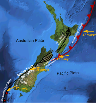
The Hikurangi Margin is New Zealand's largest subduction zone and fault.

The North Fiji Basin (NFB) is an oceanic basin west of Fiji in the south-west Pacific Ocean. It is an actively spreading back-arc basin delimited by the Fiji islands to the east, the inactive Vitiaz Trench to the north, the Vanuatu/New Hebrides island arc to the west, and the Hunter fracture zone to the south. Roughly triangular in shape with its apex located at the northern end of the New Hebrides Arc, the basin is actively spreading southward and is characterised by three spreading centres and an oceanic crust younger than 12 Ma. The opening of the NFB began when a slab roll-back was initiated beneath the New Hebrides and the island arc started its clockwise rotation. The opening of the basin was the result of the collision between the Ontong Java Plateau and the Australian Plate along the now inactive Solomon–Vitiaz subduction system north of the NFB. The NFB is the largest and most developed back-arc basin of the south-west Pacific. It is opening in a complex geological setting between two oppositely verging subduction systems, the New Hebrides/Vanuatu and Tonga trenches and hence its ocean floor has the World's largest amount of spreading centres per area.
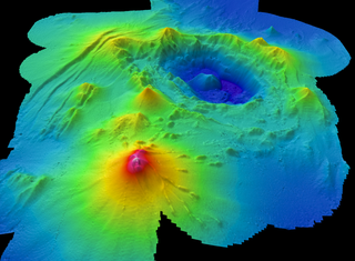
Monowai Seamount is a volcanic seamount to the north of New Zealand. It is formed by a large caldera and a volcanic cone just south-southeast from the caldera. The volcanic cone rises to depths of up to 100 metres (330 ft) but its depth varies with ongoing volcanic activity, including sector collapses and the growth of lava domes. The seamount and its volcanism were discovered after 1877, but only in 1980 was it named "Monowai" after a research ship of the same name.

The Wishbone scarp is a Pacific Ocean floor feature in the oceanic crust, that if it were on land would be similar to a mountain range fault system over 1,000 km (620 mi) long. It commences in the north near the Osbourn Trough although it appears related tectonically to the Manihiki scarp to its north. To the south it splits into west and east scarps that have been intercepted by the Louisville hotspot with the West Wishbone scarp continuing until it intercepts the Chatham Rise. The recent definite ability to assign its southern Western Wishbone scarp portion to primarily a dextral strike-slip fault that was active in the Late Cretaceous makes a fracture zone origin more likely for the entire scarp as the Eastern Wishborn scarp had already been characterised as a Cretaceous fracture zone.
The Osbourn Trough, is a 900 km (560 mi)-long extinct mid-ocean ridge, that may have stopped spreading as recently as 79 million years ago. It is a west-to-east oriented sea floor feature, located to the east of the present Tonga-Kermadec Ridge where the present Pacific Plate is under going subduction under a micro-plate of the Australian Plate. The Osbourn Trough is key to understanding the postulated breakup mechanism of the historic massive Ontong Java-Manihiki-Hikurangi large igneous province (LIP), as it has been shown to be the spreading centre that lead to the separation of the Manihiki Plateau to its north and the Hikurangi Plateau to its south close to New Zealand.
The Lau-Colville Ridge is an extinct oceanic ridge located on the oceanic Australian Plate in the south-west Pacific Ocean extending about 2,700 km (1,700 mi) from the south east of Fiji to the continental shelf margin of the North Island of New Zealand. It was an historic subduction boundary between the Australian Plate and the Pacific Plate and has important tectonic relationships to its east where very active spreading and subduction processes exist today. It is now the inactive part of an eastward-migrating, 100 million year old Lau-Tonga-Havre-Kermadec arc/back-arc system or complex and is important in understanding submarine arc volcanism because of these relationships. To its west is the South Fiji Basin whose bedrock is Oligocene in origin.
The Havre Trough is a currently actively rifting back-arc basin between 100 km (62 mi) to 120 km (75 mi) wide between the Australian Plate and Kermadec microplate. The trough extends northward from New Zealand's offshore Taupō Volcanic Zone commencing at Zealandia's continental shelf margin and continuing as a tectonic feature as the Lau Basin which is currently an active spreading centre. Its eastern margin is defined by the Kermadec Ridge created by Pacific Plate subduction under the Kermadec microplate, while the western margin is the remnant Lau-Colville Ridge.