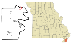
Hayward, Missouri

Last updated
Hayward, Missouri
Pemiscot County Missouri Incorporated and Unincorporated areas Hayward Highlighted.svg
Location of Hayward, Missouri
Coordinates: 36°23′46″N89°40′00″W / 36.39611°N 89.66667°W / 36.39611; -89.66667 Coordinates: 36°23′46″N89°40′00″W / 36.39611°N 89.66667°W / 36.39611; -89.66667
Country United States
State Missouri
County Pemiscot
Area
[1]
  Total0.25 sq mi (0.66 km2)
  Land0.25 sq mi (0.66 km2)
  Water0.00 sq mi (0.00 km2)
Elevation
[2]
282 ft (86 m)
Population
 (2020)
  Total93
  Density367.59/sq mi (141.95/km2)
Time zone UTC-6 (Central (CST))
  Summer (DST) UTC-5 (CDT)
FIPS code 29-31186 [3]
GNIS feature ID2587079 [2]

Hayward is a census-designated place and former village in Pemiscot County, Missouri, United States. The population was 131 at the 2010 census.

Contents

History

An early variant name was "Fisher", after John J. Fisher, an early settler. [4] A post office called Fisher was established in 1880. [5] The present name is after one Mr. Hayward, another early citizen. [4] A post office called Hayward has been in operation since 1895. [5]

The village disincorporated in 2000. [6] Hayward is now an unincorporated community classified by the Census Bureau as a census-designated place. [7]

Geography

According to the United States Census Bureau, the CDP has a total area of 0.25 square miles (0.65 km2), all land. [8]

Demographics

Historical population
CensusPop.Note
2020 93
U.S. Decennial Census [9]

2010 census

As of the census [10] of 2010, there were 131 people, 49 households, and 39 families living in the CDP. The population density was 524.0 inhabitants per square mile (202.3/km2). There were 56 housing units at an average density of 224.0 per square mile (86.5/km2). The racial makeup of the CDP was 99.24% White and 0.76% from two or more races.

There were 49 households, of which 36.7% had children under the age of 18 living with them, 59.2% were married couples living together, 12.2% had a female householder with no husband present, 8.2% had a male householder with no wife present, and 20.4% were non-families. 18.4% of all households were made up of individuals, and 6.1% had someone living alone who was 65 years of age or older. The average household size was 2.67 and the average family size was 2.92.

The median age in the CDP was 38.5 years. 24.4% of residents were under the age of 18; 9.2% were between the ages of 18 and 24; 21.4% were from 25 to 44; 33.6% were from 45 to 64; and 11.5% were 65 years of age or older. The gender makeup of the CDP was 46.6% male and 53.4% female.

2000 census

As of the census [3] of 2000, there were 123 people, 45 households, and 31 families living in the town. The population density was 521.2 inhabitants per square mile (201.2/km2). There were 48 housing units at an average density of 203.4 per square mile (78.5/km2). The racial makeup of the town was 100.00% White.

There were 45 households, out of which 26.7% had children under the age of 18 living with them, 68.9% were married couples living together, 2.2% had a female householder with no husband present, and 28.9% were non-families. 24.4% of all households were made up of individuals, and 15.6% had someone living alone who was 65 years of age or older. The average household size was 2.73 and the average family size was 3.16.

In the town the population was spread out, with 24.4% under the age of 18, 10.6% from 18 to 24, 31.7% from 25 to 44, 19.5% from 45 to 64, and 13.8% who were 65 years of age or older. The median age was 37 years. For every 100 females there were 75.7 males. For every 100 females age 18 and over, there were 78.8 males.

The median income for a household in the town was $34,375, and the median income for a family was $43,750. Males had a median income of $29,583 versus $17,031 for females. The per capita income for the town was $12,720. There were no families and 1.6% of the population living below the poverty line, including no under eighteens and 13.3% of those over 64.

Related Research Articles

<span class="mw-page-title-main">Rock Creek, Alabama</span> CDP in Alabama, United States

Rock Creek is a census-designated place in Jefferson County, Alabama, United States. Its location is northwest of Hueytown. At the 2020 census, the population was 1,471. This area was damaged by an F5 tornado on April 8, 1998. An EF2 tornado struck northwest from here on January 23, 2012.

<span class="mw-page-title-main">Underwood-Petersville, Alabama</span> Census-designated place in Alabama, United States

Underwood-Petersville is a census-designated place (CDP) in Lauderdale County, Alabama United States. It is part of the Florence - Muscle Shoals Metropolitan Statistical Area known as "The Shoals". As of the 2010 census, the population of the CDP is 3,247.

<span class="mw-page-title-main">Mignon, Alabama</span> CDP in Alabama, United States

Mignon is a census-designated place (CDP) in Talladega County, Alabama, United States. At the 2020 census, the population was 1,186.

<span class="mw-page-title-main">Ashland, California</span> Unincorporated community in California, United States

Ashland is a census-designated place (CDP) and unincorporated community in Alameda County, California, United States. The population was 23,823 at the 2020 census. Ashland is located between the city of San Leandro to the north, the unincorporated community of Cherryland to the south, the unincorporated community of Castro Valley to the east, and the unincorporated community of San Lorenzo to the southwest.

<span class="mw-page-title-main">Cherryland, California</span> Unincorporated Community in California, United States

Cherryland is an unincorporated community and census-designated place (CDP) in Alameda County, California, United States. Cherryland is located between Ashland to the north and the city of Hayward to the south. The population was 15,808 at the 2020 census.

<span class="mw-page-title-main">Fairview, California</span> CDP in California, United States

Fairview is a census-designated place (CDP) in Alameda County, California, United States. It borders on the city of Hayward and the census-designated place of Castro Valley. The population was 11,341 at the 2020 census.

<span class="mw-page-title-main">Desert View Highlands, California</span> Census designated place in California, United States

Desert View Highlands is a census-designated place (CDP) in Los Angeles County, California, United States. The population was 2,360 at the 2010 census, up from 2,337 at the 2000 census. It is surrounded by the City of Palmdale.

<span class="mw-page-title-main">North El Monte, California</span> Census-designated place in California, United States

North El Monte is a census-designated place (CDP) in the San Gabriel Valley, in Los Angeles County, California, United States. The population was 3,723 at the 2010 census, up from 3,703 at the 2000 census.

<span class="mw-page-title-main">Morada, California</span> Census-designated place in California, United States

Morada is a census-designated place (CDP) in San Joaquin County, California, United States. The population was 3,166 at the 2020 census, down from 3,828 at the 2010 census.

Coyne Center is a census-designated place (CDP) in Rock Island County, Illinois, United States. The population was 827 at the 2010 census.

<span class="mw-page-title-main">Bragg City, Missouri</span> City in Missouri, United States

Bragg City is a city in Pemiscot County, Missouri, United States. The population was 72 at the 2020 census.

<span class="mw-page-title-main">Cooter, Missouri</span> City in Missouri, United States

Cooter is a city in Pemiscot County, Missouri, United States. The population was 343 at the 2020 census.

<span class="mw-page-title-main">Hayti Heights, Missouri</span> City in Missouri, United States

Hayti Heights is a city in eastern Pemiscot County in the bootheel of southeast Missouri, United States. The population was 515 at the 2020 census.

<span class="mw-page-title-main">Holland, Missouri</span> Town in Missouri, United States

Holland is a town in Pemiscot County, Missouri, United States. The population was 194 at the 2020 census.

<span class="mw-page-title-main">Homestown, Missouri</span> City in Missouri, United States

Homestown is a city in Pemiscot County, Missouri, United States. The population was 73 at the 2020 census.

<span class="mw-page-title-main">Pascola, Missouri</span> Village in Missouri, United States

Pascola is a village in Pemiscot County, Missouri, United States. The population was 108 at the 2010 census.

<span class="mw-page-title-main">Steele, Missouri</span> City in Missouri, United States

Steele is a city in southern Pemiscot County in the Missouri Bootheel of southeastern Missouri, United States. The population was 1,853 at the 2020 census.

<span class="mw-page-title-main">Wardell, Missouri</span> City in Missouri, United States

Wardell is a city in Pemiscot County, Missouri, United States. The population was 310 at the 2020 census. It annexed North Wardell in 2007.

<span class="mw-page-title-main">Wye, Montana</span> Place in Montana, United States

Wye is a unincorporated community in Missoula County, Montana, United States. It is part of the Missoula, Montana Metropolitan Statistical Area. The population was 511 at the 2010 census, an increase from its population of 381 in 2000. For statistical purposes, the United States Census Bureau has defined Saticoy as a census-designated place (CDP). Wye is named for the "y"-shaped DeSmet Junction where US 93 and MT 200 met former US 10.

<span class="mw-page-title-main">Chief Lake, Wisconsin</span> CDP in Wisconsin, United States

Chief Lake is a census-designated place (CDP) in the town of Hayward, Sawyer County, Wisconsin, United States. The population was 583 at the 2010 census.

References

  1. "ArcGIS REST Services Directory". United States Census Bureau. Retrieved August 28, 2022.
  2. 1 2 U.S. Geological Survey Geographic Names Information System: Hayward, Missouri
  3. 1 2 "U.S. Census website". United States Census Bureau . Retrieved 2008-01-31.
  4. 1 2 "Pemiscot County Place Names, 1928–1945". The State Historical Society of Missouri. Archived from the original on June 24, 2016. Retrieved November 29, 2016.
  5. 1 2 "Post Offices". Jim Forte Postal History. Retrieved 29 November 2016.
  6. "Boundary Changes".
  7. U.S. Geological Survey Geographic Names Information System: Hayward Census Designated Place
  8. "US Gazetteer files 2010". United States Census Bureau . Retrieved 2012-07-08.
  9. "Census of Population and Housing". Census.gov. Retrieved June 4, 2016.
  10. "U.S. Census website". United States Census Bureau . Retrieved 2012-07-08.