Portageville, Missouri

Last updated

Portageville, Missouri
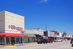
Portageville-Main-Street-mo.jpg
Main Street
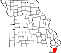
New Madrid County Missouri Incorporated and Unincorporated areas Portageville Highlighted.svg
Location of Portageville, Missouri
Coordinates: 36°25′46″N89°41′58″W / 36.42944°N 89.69944°W / 36.42944; -89.69944
Country United States
State Missouri
Counties New Madrid, Pemiscot
Government
  TypeMayor/council system
  MayorDennis Walker
  AldermenKristine Adams, Shirley Estes, Patty Johnson, James Hollingshead
Area
[1]
  Total2.04 sq mi (5.28 km2)
  Land2.04 sq mi (5.28 km2)
  Water0.00 sq mi (0.00 km2)
Elevation
[2]
282 ft (86 m)
Population
 (2020)
  Total2,942
  Density1,442.16/sq mi (556.73/km2)
Time zone UTC-6 (Central (CST))
  Summer (DST) UTC-5 (CDT)
ZIP code
63873
Area code 573
FIPS code 29-59186 [3]
GNIS feature ID2396256 [2]

Portageville is a city in New Madrid and Pemiscot counties in the U.S. state of Missouri. The population was 2,942 according to the 2020 Census. [4]

Contents

History

A post office called Portageville has been in operation since 1873. [5] The community takes its name from nearby Portage Bayou. [6]

From 1935 to 1936, Portageville was the home of the Portageville Pirates, part of the Kitty League. "In 1935, the Portageville Pirates are awarded the second-half title after the Jackson Generals and Union City Greyhounds are disqualified for having too many class players on their rosters." [7] In 1936, the Pirates relocated to Owensboro, Kentucky.[ citation needed ]

Geography

Portageville is located primarily in New Madrid County. It lies along U.S. Route 61 and Missouri Route 162, which converge briefly as they pass through the city. Interstate 55 passes through the eastern part of the city. Portageville is about 5 miles (8.0 km) west of the Mississippi River.

According to the United States Census Bureau, the city has a total area of 2.04 square miles (5.28 km2), all land. [8]

Climate

The climate in this area is characterized by hot, humid summers and generally mild to cool winters. According to the Köppen Climate Classification system, Portageville has a humid subtropical climate, abbreviated "Cfa" on climate maps. [9]

Climate data for Portageville, Missouri
MonthJanFebMarAprMayJunJulAugSepOctNovDecYear
Average high °C (°F)6
(42)
8
(47)
14
(58)
21
(69)
26
(78)
31
(87)
32
(90)
31
(88)
27
(81)
22
(71)
14
(58)
8
(46)
20
(68)
Average low °C (°F)−3
(27)
−1
(30)
4
(39)
9
(49)
14
(58)
19
(67)
21
(70)
20
(68)
16
(60)
9
(48)
4
(40)
−1
(30)
9
(49)
Average precipitation mm (inches)86
(3.4)
84
(3.3)
110
(4.3)
130
(5)
130
(5)
99
(3.9)
94
(3.7)
69
(2.7)
91
(3.6)
91
(3.6)
110
(4.2)
110
(4.4)
1,200
(47.2)
Source: Weatherbase [10]

Demographics

Historical population
CensusPop.Note
1880 73
1900 427
1910 987131.1%
1920 1,24426.0%
1930 1,2621.4%
1940 2,10767.0%
1950 2,66226.3%
1960 2,505−5.9%
1970 3,11724.4%
1980 3,47011.3%
1990 3,401−2.0%
2000 3,295−3.1%
2010 3,228−2.0%
2020 2,942−8.9%
source: [11]

2010 census

As of the census [12] of 2010, there were 3,228 people, 1,346 households, and 894 families living in the city. The population density was 1,582.4 inhabitants per square mile (611.0/km2). There were 1,409 housing units at an average density of 690.7 per square mile (266.7/km2). The racial makeup of the city was 78.62% White, 18.96% Black or African American, 0.06% Native American, 0.19% Asian, 0.19% from other races, and 1.98% from two or more races. Hispanic or Latino of any race were 0.87% of the population.

There were 1,346 households, of which 34.0% had children under the age of 18 living with them, 43.6% were married couples living together, 17.5% had a female householder with no husband present, 5.3% had a male householder with no wife present, and 33.6% were non-families. 29.8% of all households were made up of individuals, and 14.2% had someone living alone who was 65 years of age or older. The average household size was 2.37 and the average family size was 2.92.

The median age in the city was 38.6 years. 25.7% of residents were under the age of 18; 7.9% were between the ages of 18 and 24; 24% were from 25 to 44; 26% were from 45 to 64; and 16.4% were 65 years of age or older. The gender makeup of the city was 46.4% male and 53.6% female.

2000 census

As of the census [3] of 2000, there were 3,295 people, 1,335 households, and 890 families living in the city. The population density was 1,643.5 inhabitants per square mile (634.6/km2). There were 1,404 housing units at an average density of 700.3 per square mile (270.4/km2). The racial makeup of the city was 82.00% White, 16.36% African American, 0.18% Native American, 0.30% Asian, 0.27% from other races, and 0.88% from two or more races. Hispanic or Latino of any race were 0.82% of the population.

There were 1,335 households, out of which 33.3% had children under the age of 18 living with them, 46.4% were married couples living together, 17.3% had a female householder with no husband present, and 33.3% were non-families. 29.6% of all households were made up of individuals, and 15.1% had someone living alone who was 65 years of age or older. The average household size was 2.43 and the average family size was 3.02.

In the city, the population was spread out, with 27.3% under the age of 18, 9.3% from 18 to 24, 26.4% from 25 to 44, 20.9% from 45 to 64, and 16.2% who were 65 years of age or older. The median age was 37 years. For every 100 females there were 84.6 males. For every 100 females age 18 and over, there were 77.4 males.

The median income for a household in the city was $26,729, and the median income for a family was $35,913. Males had a median income of $31,325 versus $20,735 for females. The per capita income for the city was $15,114. About 21.4% of families and 27.0% of the population were below the poverty line, including 37.8% of those under age 18 and 25.1% of those age 65 or over.
Education

Portageville School District operates one elementary school, one middle school and Portageville High School. [13]

Portageville has a lending library, a branch of the New Madrid County Library. [14]

Notable people

See also

Related Research Articles

<span class="mw-page-title-main">Brookwood, Alabama</span> City in Alabama, United States

Brookwood is a city in Tuscaloosa County, Alabama, United States. It incorporated in September 1977. As of the 2020 census, the population of the town is 2,504.

<span class="mw-page-title-main">Manila, Arkansas</span> City in Arkansas, United States

Manila is a city in Mississippi County, Arkansas, United States. The population was 3,682 at the 2020 census, up from 3,342 in 2010. It was the hometown of World War I sniper Herman Davis. A park in the town honors his memory.

<span class="mw-page-title-main">Benton, Arkansas</span> City in Arkansas, United States

Benton is a city in and the county seat of Saline County, Arkansas, United States and a suburb of Little Rock. It was established in 1837. At the 2010 census, the city had a population of 30,681. In 2019 the population was estimated at 36,820. It is part of the Little Rock–North Little Rock–Conway Metropolitan Statistical Area. The city of Benton, first settled in 1833 and named after Missouri Senator Thomas Hart Benton, was formally chartered in 1836 when Arkansas became a state.

<span class="mw-page-title-main">Kingman, Kansas</span> City in Kingman County, Kansas

Kingman is a city in and the county seat of Kingman County, Kansas, United States. As of the 2020 census, the population of the city was 3,105.

<span class="mw-page-title-main">Central Lake, Michigan</span> Village in Michigan, United States

Central Lake is a village in Antrim County in the U.S. state of Michigan. The population was 952 at the 2010 census. The village is located within Central Lake Township.

<span class="mw-page-title-main">Elizabeth, Minnesota</span> City in Minnesota, United States

Elizabeth is a city in Otter Tail County, Minnesota, United States. The population was 168 at the 2020 census.

<span class="mw-page-title-main">Airport Drive, Missouri</span> Village in Missouri, United States

Airport Drive is a village in Jasper County, Missouri, United States. The population was 766 at the 2020 census. It is part of the Joplin, Missouri Metropolitan Statistical Area. The community is still commonly referred to as "Stone's Corner," as the intersection of Route 43 and Route 171 is known.

<span class="mw-page-title-main">Laurie, Missouri</span> City in Missouri, United States

Laurie is a city in southern Morgan and northern Camden counties, Missouri, United States. The population was 945 at the 2010 census.

<span class="mw-page-title-main">Marston, Missouri</span> City in Missouri, United States

Marston is a city in New Madrid County, Missouri, United States. The population was 503 at the 2010 census.

<span class="mw-page-title-main">Linn, Missouri</span> City in Missouri, United States

Linn is a city in Osage County, Missouri, United States. The population was 1,350 at the 2020 census. It is the county seat of Osage County. Linn is part of the Jefferson City, Missouri Metropolitan Statistical Area.

<span class="mw-page-title-main">Hazelwood, Missouri</span> City in Missouri, United States

Hazelwood is a city in St. Louis County, Missouri, within Greater St. Louis. It is a second-ring northern suburb of St. Louis. Based on the 2020 United States census, the city had a total population of 25,485. It is located north of St. Louis-Lambert International Airport and is situated on Interstates 270 and 170, as well as the much-traveled Lindbergh Boulevard and Highway 370.

<span class="mw-page-title-main">Advance, Missouri</span> City in Missouri, United States

Advance is a city located at the intersection of State Highway 25 and State Highway 91/Route C in northern Stoddard County, Missouri, United States. The population was 1,347 at the 2010 census. Advance was founded circa 1882. The town is pronounced ADD-vance.

<span class="mw-page-title-main">Merriman, Nebraska</span> Village in Nebraska, United States

Merriman is a village in Cherry County, Nebraska. The population was 128 at the time of the 2010 census.

<span class="mw-page-title-main">Creighton, Nebraska</span> City in Nebraska, United States

Creighton is a city in Knox County, Nebraska, United States. The population was 1,154 at the 2010 census.

<span class="mw-page-title-main">Bowman, North Dakota</span> City in North Dakota, United States

Bowman is a city and county seat of Bowman County, North Dakota, United States. The population was 1,470 at the 2020 census.

<span class="mw-page-title-main">Philomath, Oregon</span> City in Oregon, United States

Philomath is a city in Benton County, Oregon, United States. It was named for Philomath College. The population was 4,584 at the 2010 census and was most recently estimated in 2019 to have a population of 5,666. It is part of the Corvallis, Oregon, Metropolitan Statistical Area.

<span class="mw-page-title-main">Falls City, Oregon</span> City in Oregon, United States

Falls City is a city in Polk County, Oregon, United States. The population was 1,051 at the 2020 census. It is part of the Salem Metropolitan Statistical Area.

<span class="mw-page-title-main">Mattawa, Washington</span> City in Washington, United States

Mattawa is an incorporated city in Grant County, Washington, United States. The population was 3,335 at the 2020 census.

<span class="mw-page-title-main">Burnsville, West Virginia</span> Town in West Virginia, United States

Burnsville is a town in Braxton County, West Virginia, United States, at the confluence of the Little Kanawha River and Saltlick Creek. The population was 401 at the 2020 census. Burnsville was incorporated in 1902 by the Circuit Court and named for Captain John Burns who operated the first sawmill in that section of the state and who established the town shortly after the close of the American Civil War. It was named "All West Virginia City" in 1976.

<span class="mw-page-title-main">Henderson, West Virginia</span> Unincorporated Town in West Virginia, United States

Henderson is an unincorporated community and former town in Mason County, West Virginia, United States, at the confluence of the Ohio and Kanawha Rivers. The population was 231 at the 2020 census. It is part of the Point Pleasant, WV–OH Micropolitan Statistical Area. The town was incorporated in 1893 and named for Samuel Bruce Henderson, who owned the townsite at the time. The town was unincorporated following a public hearing on August 11, 2022.

References

  1. "ArcGIS REST Services Directory". United States Census Bureau. Retrieved August 28, 2022.
  2. 1 2 U.S. Geological Survey Geographic Names Information System: Portageville, Missouri
  3. 1 2 "U.S. Census website". United States Census Bureau . Retrieved January 31, 2008.
  4. "Explore Census Data". data.census.gov. Retrieved September 30, 2022.
  5. "Post Offices". Jim Forte Postal History. Retrieved November 19, 2016.
  6. "New Madrid County Place Names, 1928–1945". The State Historical Society of Missouri. Archived from the original on June 24, 2016. Retrieved November 19, 2016.
  7. "Chronology". Kittyleague.com. Retrieved October 19, 2018.
  8. "US Gazetteer files 2010". United States Census Bureau. Archived from the original on July 2, 2012. Retrieved July 8, 2012.
  9. "Portageville, Missouri Köppen Climate Classification". Weatherbase.com. Retrieved October 19, 2018.
  10. "Weatherbase.com". Weatherbase. 2013. Retrieved on October 25, 2013.
  11. "Missouri Population 1900 - 1990" (PDF). Missouri Census Data Center. Archived from the original (CSV) on July 4, 2014. Retrieved October 6, 2014.
  12. "U.S. Census website". United States Census Bureau . Retrieved July 8, 2012.
  13. "Portageville School District". Great Schools. Retrieved June 1, 2019.
  14. "Our Locations". New Madrid County Library. Retrieved June 1, 2019.
  15. Cheney, David M. "Bishop Luis Morgan Casey [Catholic-Hierarchy]". Catholic-hierarchy.org. Retrieved October 19, 2018.
  16. 'Vermel M. Whelan spent 12 years in the Ohio House: news obituary,' The Plain Dealer, Grant Segall, March 15, 2013